Estimated Value: $431,000 - $625,723
3
Beds
2
Baths
2,761
Sq Ft
$194/Sq Ft
Est. Value
About This Home
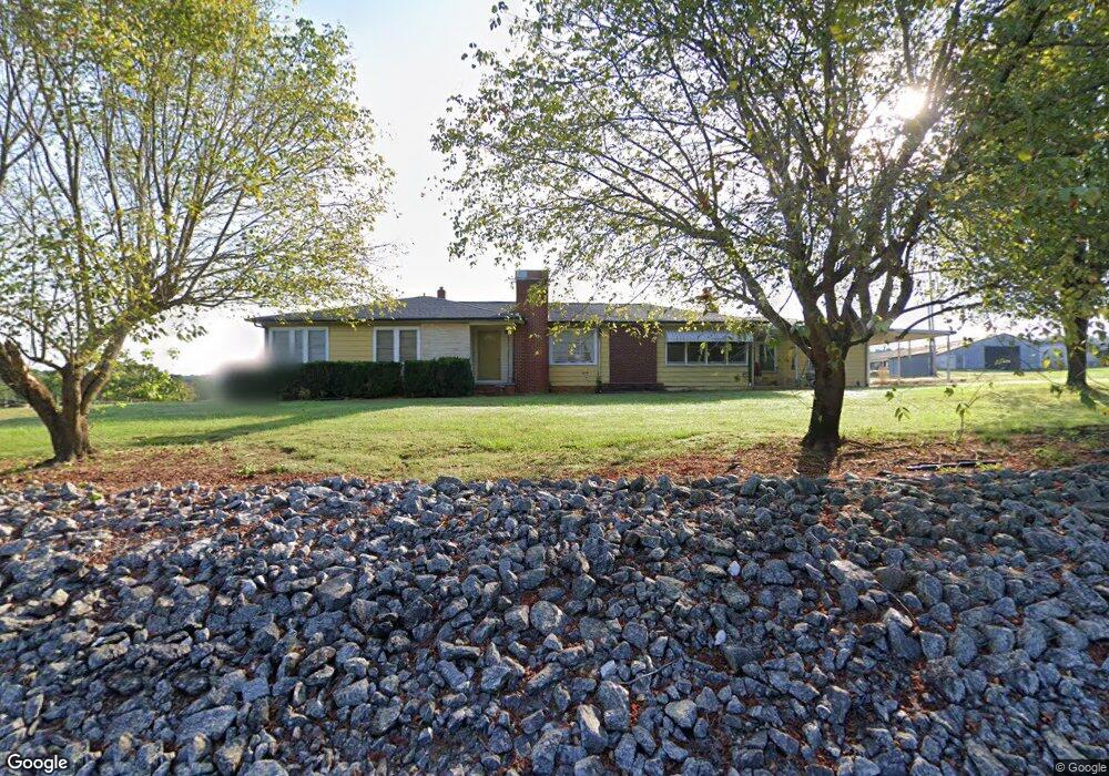
This home is located at 5324 Abernethy Farm Rd, Vale, NC 28168 and is currently estimated at $535,681, approximately $194 per square foot. 5324 Abernethy Farm Rd is a home located in Lincoln County with nearby schools including Union Elementary School, West Lincoln Middle, and West Lincoln High School.
Ownership History
Date
Name
Owned For
Owner Type
Purchase Details
Closed on
Aug 23, 2022
Sold by
Lelia H Abernethy Irrevocable Trust
Bought by
Hoyle Renee Abernethy and Abernethy Robert E
Current Estimated Value
Purchase Details
Closed on
Jan 19, 2017
Sold by
Abernethy Randy H and Abernethy Brenda A
Bought by
Pump Kelsey W
Purchase Details
Closed on
Jul 8, 2016
Sold by
Abernethy Lelia H
Bought by
Abernethy Hoyle Renee and Abernethy Randy Houser
Create a Home Valuation Report for This Property
The Home Valuation Report is an in-depth analysis detailing your home's value as well as a comparison with similar homes in the area
Home Values in the Area
Average Home Value in this Area
Purchase History
| Date | Buyer | Sale Price | Title Company |
|---|---|---|---|
| Hoyle Renee Abernethy | -- | -- | |
| Pump Kelsey W | -- | None Available | |
| Abernethy Randy H | -- | None Available | |
| Abernethy Hoyle Renee | -- | None Available |
Source: Public Records
Tax History Compared to Growth
Tax History
| Year | Tax Paid | Tax Assessment Tax Assessment Total Assessment is a certain percentage of the fair market value that is determined by local assessors to be the total taxable value of land and additions on the property. | Land | Improvement |
|---|---|---|---|---|
| 2025 | $2,119 | $462,929 | $184,407 | $278,522 |
| 2024 | $2,099 | $462,929 | $184,407 | $278,522 |
| 2023 | $2,094 | $462,929 | $184,407 | $278,522 |
| 2022 | $1,528 | $293,072 | $135,750 | $157,322 |
| 2021 | $1,528 | $300,506 | $135,750 | $164,756 |
| 2020 | $1,429 | $300,988 | $136,232 | $164,756 |
| 2019 | $1,429 | $300,988 | $136,232 | $164,756 |
| 2018 | $1,399 | $278,996 | $132,868 | $146,128 |
| 2017 | $1,301 | $146,128 | $0 | $146,128 |
| 2016 | $1,239 | $281,549 | $135,421 | $146,128 |
| 2015 | $1,300 | $281,549 | $135,421 | $146,128 |
| 2014 | $1,355 | $300,964 | $143,605 | $157,359 |
Source: Public Records
Map
Nearby Homes
- 3243 Wilson Ct Unit 11
- 5298 Hoover Elmore Rd
- 00 Wilson Ct Unit 12
- 00 Wilson Ct Unit 13
- 00 Wilson Ct Unit 15
- 1855 Jetton Dr
- 4773 Westwinds Rd
- 3987 W Highway 27
- 00 Westwinds Rd Unit F3
- 000 Doral Ln
- 00 McCurry Farm Ln Unit F1 & F2
- Lot 35 Sparrow Ln Unit 35
- 00000 Reepsville Rd
- 000000 Reepsville Rd
- 7058 Sparrow Ln
- 4318 Katie Reep Ln
- 5436 N Carolina 27
- 6722 Workman Ln
- 2486 Ridge Run Ln
- 4832 Gideon Dr
- 5261 Abernethy Farm Rd
- 5173 John Flowers Ln
- 5171 John Flowers Ln
- 5454 Abernethy Farm Rd
- 5533 Abernethy Farm Rd
- 5030 Grigg Rd
- 5709 Hoover Elmore Rd
- 5680 Hoover Elmore Rd
- 5072 Grigg Rd
- 0000 Hoover Elmore Rd
- 000 Hoover Elmore Rd
- Tract 2 Hoover Elmore Rd
- Tract 1 Hoover Elmore Rd
- 5845 Hoover Elmore Rd
- 5650 Hoover Elmore Rd
- 5793 Hoover Elmore Rd
- 5616 Hoover Elmore Rd
- 5712 Hoover Elmore Rd
- 5596 Hoover Elmore Rd
- 5764 Hoover Elmore Rd