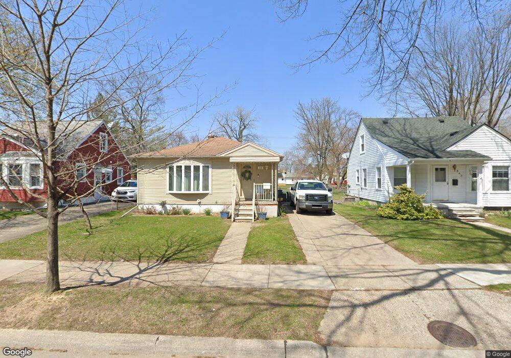
533 E Baker Ave Clawson, MI 48017
Estimated Value: $211,000 - $275,000
3
Beds
1
Bath
975
Sq Ft
$253/Sq Ft
Est. Value
About This Home
This home is located at 533 E Baker Ave, Clawson, MI 48017 and is currently estimated at $246,570, approximately $252 per square foot. 533 E Baker Ave is a home located in Oakland County with nearby schools including Clawson Middle School, Clawson High School, and Guardian Angels School.
Ownership History
Date
Name
Owned For
Owner Type
Purchase Details
Closed on
Dec 19, 2018
Sold by
Durantini Marie Elaine and Stearns Lisa Ann Garnette
Bought by
Fulner Edward
Current Estimated Value
Home Financials for this Owner
Home Financials are based on the most recent Mortgage that was taken out on this home.
Original Mortgage
$142,000
Outstanding Balance
$124,626
Interest Rate
4.9%
Mortgage Type
New Conventional
Estimated Equity
$121,944
Create a Home Valuation Report for This Property
The Home Valuation Report is an in-depth analysis detailing your home's value as well as a comparison with similar homes in the area
Home Values in the Area
Average Home Value in this Area
Purchase History
| Date | Buyer | Sale Price | Title Company |
|---|---|---|---|
| Fulner Edward | $142,000 | Cislo Title Company |
Source: Public Records
Mortgage History
| Date | Status | Borrower | Loan Amount |
|---|---|---|---|
| Open | Fulner Edward | $142,000 |
Source: Public Records
Tax History
| Year | Tax Paid | Tax Assessment Tax Assessment Total Assessment is a certain percentage of the fair market value that is determined by local assessors to be the total taxable value of land and additions on the property. | Land | Improvement |
|---|---|---|---|---|
| 2025 | $4,161 | $111,080 | $0 | $0 |
| 2024 | $3,976 | $106,450 | $0 | $0 |
| 2023 | $3,812 | $96,950 | $0 | $0 |
| 2022 | $3,842 | $87,460 | $0 | $0 |
| 2021 | $3,764 | $81,330 | $0 | $0 |
| 2020 | $3,646 | $78,580 | $0 | $0 |
| 2019 | $3,768 | $74,560 | $0 | $0 |
| 2018 | $2,199 | $68,140 | $0 | $0 |
| 2017 | $2,186 | $64,070 | $0 | $0 |
| 2016 | $2,221 | $59,760 | $0 | $0 |
| 2015 | -- | $54,770 | $0 | $0 |
| 2014 | -- | $47,250 | $0 | $0 |
| 2011 | -- | $42,760 | $0 | $0 |
Source: Public Records
Map
Nearby Homes
- 609 E Baker Ave
- 550 Roth Blvd
- 917 Kenwood St
- 911 Kenwood St
- 909 Kenwood St
- 918 Kenwood St
- 57 W Elmwood Ave
- 150 Wilson Ave
- 114 Knollwood Blvd
- 45 E Tacoma St
- 1121 Ottawa Ave
- 101 Jefferson Ave
- 44 W Tacoma St
- 124 Leroy Ave
- 1101 Donald Ave
- 1205 Donald Ave
- 428 Bauman Ave
- 138 Chopin St
- 135 Gerald Ave
- 503 W Elmwood Ave
- 543 E Baker Ave
- 523 E Baker Ave
- 551 E Baker Ave
- 505 E Baker Ave
- 561 E Baker Ave
- 546 E Baker Ave
- 534 E Baker Ave
- 528 E Baker Ave
- 571 E Baker Ave
- 495 E Baker Ave
- 579 E Baker Ave
- 516 E Baker Ave
- 556 E Baker Ave
- 508 E Baker Ave
- 576 E Baker Ave
- 589 E Baker Ave
- 496 E Baker Ave
- 487 E Baker Ave
- 584 E Baker Ave
- 477 E Baker Ave
Your Personal Tour Guide
Ask me questions while you tour the home.