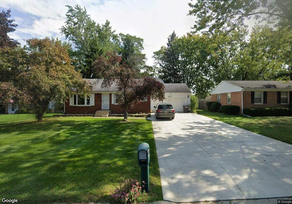
533 Rutledge St Jackson, MI 49203
Estimated Value: $255,000 - $327,000
5
Beds
2
Baths
2,632
Sq Ft
$112/Sq Ft
Est. Value
About This Home
This home is located at 533 Rutledge St, Jackson, MI 49203 and is currently estimated at $295,652, approximately $112 per square foot. 533 Rutledge St is a home located in Jackson County with nearby schools including Hunt Elementary School, Middle School at Parkside, and Jackson High School.
Ownership History
Date
Name
Owned For
Owner Type
Purchase Details
Closed on
Sep 28, 2000
Sold by
Wilkinson Carole J and Cook Carole J
Bought by
North George M and North Kelly B
Current Estimated Value
Home Financials for this Owner
Home Financials are based on the most recent Mortgage that was taken out on this home.
Original Mortgage
$97,200
Outstanding Balance
$35,625
Interest Rate
7.99%
Mortgage Type
Purchase Money Mortgage
Estimated Equity
$260,027
Create a Home Valuation Report for This Property
The Home Valuation Report is an in-depth analysis detailing your home's value as well as a comparison with similar homes in the area
Home Values in the Area
Average Home Value in this Area
Purchase History
| Date | Buyer | Sale Price | Title Company |
|---|---|---|---|
| North George M | $108,000 | -- |
Source: Public Records
Mortgage History
| Date | Status | Borrower | Loan Amount |
|---|---|---|---|
| Open | North George M | $97,200 |
Source: Public Records
Tax History
| Year | Tax Paid | Tax Assessment Tax Assessment Total Assessment is a certain percentage of the fair market value that is determined by local assessors to be the total taxable value of land and additions on the property. | Land | Improvement |
|---|---|---|---|---|
| 2025 | $5,250 | $153,300 | $0 | $0 |
| 2024 | $40 | $152,300 | $0 | $0 |
| 2023 | $3,845 | $141,300 | $0 | $0 |
| 2022 | $3,200 | $128,600 | $0 | $0 |
| 2021 | $3,156 | $125,400 | $0 | $0 |
| 2020 | $3,121 | $120,100 | $0 | $0 |
| 2019 | $3,091 | $113,800 | $0 | $0 |
| 2018 | $2,984 | $106,600 | $0 | $0 |
| 2017 | $2,382 | $105,500 | $0 | $0 |
| 2016 | $1,608 | $102,300 | $102,300 | $0 |
| 2015 | $2,255 | $81,300 | $81,300 | $0 |
| 2014 | $2,255 | $76,700 | $0 | $0 |
| 2013 | -- | $76,700 | $76,700 | $0 |
Source: Public Records
Map
Nearby Homes
- 3844 Westchester Blvd
- 0 Evelyn St
- 242 Kenneth St
- 3250 Carlton Blvd
- 732 W Barrington Cir Unit 116
- 712 W Barrington Cir Unit 122
- 745 W Barrington Cir Unit 92
- 778 W Barrington Cir Unit 75
- 693 Leo Rd
- 783 W Barrington Cir Unit 45
- 2924 Sheridan Cirlce Unit 57
- 760 Woodbine Blvd
- 0 Laurence Ave Unit 25062864
- 912 Halstead Blvd
- 3219 Mccain Rd
- 4009 Magnolia Pkwy
- 534 Barrett Ave
- 4116 Mulberry Cir Unit 31
- 4650 Suffolk Ln Unit 31
- VL Laurence Ave
- 537 Rutledge St
- 529 Rutledge St
- 541 Rutledge St
- 532 Robinson Rd
- 536 Robinson Rd
- 528 Robinson Rd
- 525 Rutledge St
- 532 Rutledge St
- 540 Robinson Rd
- 536 Rutledge St
- 524 Robinson Rd
- 545 Rutledge St
- 3812 Deerfield Dr
- 540 Rutledge St
- 3816 Deerfield Dr
- 542 Robinson Rd
- 520 Robinson Rd
- 3820 Deerfield Dr
- 544 Rutledge St
- 549 Rutledge St
Your Personal Tour Guide
Ask me questions while you tour the home.