Estimated Value: $264,000 - $310,879
4
Beds
3
Baths
2,580
Sq Ft
$110/Sq Ft
Est. Value
About This Home
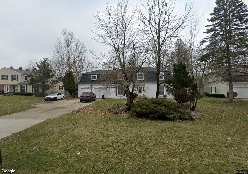
This home is located at 5332 Butternut Tree Ct, Flint, MI 48532 and is currently estimated at $283,220, approximately $109 per square foot. 5332 Butternut Tree Ct is a home located in Genesee County with nearby schools including Carman-Ainsworth High School, Genesee STEM Academy, and St. Paul Lutheran School.
Ownership History
Date
Name
Owned For
Owner Type
Purchase Details
Closed on
Mar 25, 2009
Sold by
Us Bank National Association
Bought by
English Lashon and English Willie
Current Estimated Value
Home Financials for this Owner
Home Financials are based on the most recent Mortgage that was taken out on this home.
Original Mortgage
$37,800
Outstanding Balance
$23,934
Interest Rate
5.05%
Mortgage Type
Seller Take Back
Estimated Equity
$259,286
Purchase Details
Closed on
Feb 18, 2008
Sold by
Wells Fargo Bank Na
Bought by
Us Bank National Association and Banc Of America Funding Corporation 2006
Purchase Details
Closed on
Oct 31, 2007
Sold by
Dixon Thomas M
Bought by
Wells Fargo Bank Na
Purchase Details
Closed on
Aug 1, 2003
Sold by
Hoder Richard J
Bought by
Dixon Thomas M
Create a Home Valuation Report for This Property
The Home Valuation Report is an in-depth analysis detailing your home's value as well as a comparison with similar homes in the area
Home Values in the Area
Average Home Value in this Area
Purchase History
| Date | Buyer | Sale Price | Title Company |
|---|---|---|---|
| English Lashon | $47,250 | Attorneys Title Agency Llc | |
| Us Bank National Association | -- | Attorneys Title Agency Llc | |
| Wells Fargo Bank Na | $135,000 | None Available | |
| Dixon Thomas M | $156,900 | First American Title |
Source: Public Records
Mortgage History
| Date | Status | Borrower | Loan Amount |
|---|---|---|---|
| Open | English Lashon | $37,800 |
Source: Public Records
Tax History
| Year | Tax Paid | Tax Assessment Tax Assessment Total Assessment is a certain percentage of the fair market value that is determined by local assessors to be the total taxable value of land and additions on the property. | Land | Improvement |
|---|---|---|---|---|
| 2025 | $3,096 | $141,700 | $0 | $0 |
| 2024 | $1,664 | $133,300 | $0 | $0 |
| 2023 | $1,588 | $126,800 | $0 | $0 |
| 2022 | $1,292 | $103,100 | $0 | $0 |
| 2021 | $2,734 | $90,600 | $0 | $0 |
| 2020 | $1,427 | $85,300 | $0 | $0 |
| 2019 | $1,406 | $74,400 | $0 | $0 |
| 2018 | $2,549 | $69,200 | $0 | $0 |
| 2017 | $2,534 | $69,200 | $0 | $0 |
| 2016 | $3,734 | $63,100 | $0 | $0 |
| 2015 | $2,362 | $62,000 | $0 | $0 |
| 2014 | $1,401 | $59,300 | $0 | $0 |
| 2012 | -- | $57,800 | $57,800 | $0 |
Source: Public Records
Map
Nearby Homes
- 1161 S Dye Rd
- 5477 Fernwood Dr
- 1460 S Dye Rd
- 1417 Grassmere Ave
- oo Walnut Creek Dr
- 1192 Citation Dr
- 1184 Citation Dr
- 00 Graham St
- 0000 Reuben Reuben St
- 3.9 Acres W Court St
- 1246 Dyemeadow Ln
- 2 Charter Dr
- 6142 Noel Dr
- 6090 Lancaster Dr
- 1090 Cabot Dr
- 0 Country Ridge Trail
- 5531 Sugarbush Ln
- 0 Charter Dr Unit 50153638
- 5551 Sugar Bush Ln
- 1034 Normandy Terrace Dr
- 5330 Butternut Tree Ct
- 5334 Butternut Tree Ct
- 5326 Butternut Tree Ct
- 5336 Butternut Tree Ct
- 5340 N Dyewood Dr
- 5335 Butternut Tree Ct
- 5320 N Dyewood Dr
- 1115 S Dye Rd
- 5354 N Dyewood Dr
- 5337 Butternut Tree Ct
- 1082 S Dye Rd
- 5310 N Dyewood Dr
- 5339 N Dyewood Dr
- 1137 S Dye Rd
- 1087 S Dye Rd
- 5341 Butternut Tree Ct Unit Bldg-Unit
- 5341 Butternut Tree Ct
- 1147 S Dye Rd
- 5366 Tulip Tree Ct
- 5353 N Dyewood Dr
Your Personal Tour Guide
Ask me questions while you tour the home.