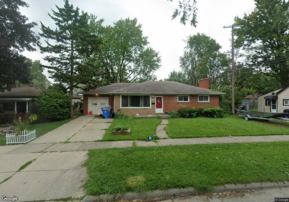
5334 Katherine St Unit Bldg-Unit Dearborn Heights, MI 48125
Estimated Value: $223,000 - $241,000
3
Beds
2
Baths
1,320
Sq Ft
$177/Sq Ft
Est. Value
About This Home
This home is located at 5334 Katherine St Unit Bldg-Unit, Dearborn Heights, MI 48125 and is currently estimated at $233,943, approximately $177 per square foot. 5334 Katherine St Unit Bldg-Unit is a home located in Wayne County with nearby schools including Polk Elementary School, Bedford School, and Pardee School.
Ownership History
Date
Name
Owned For
Owner Type
Purchase Details
Closed on
Apr 16, 2018
Sold by
Kg Property Group Llc
Bought by
Fenbert Robert
Current Estimated Value
Purchase Details
Closed on
Dec 5, 2014
Sold by
Gill Kewal and Gill Amandeep
Bought by
Kg Property Group Llc
Purchase Details
Closed on
Aug 31, 2011
Sold by
Nance Cheryl
Bought by
Gill Kewal
Purchase Details
Closed on
Aug 9, 2010
Sold by
Danko James
Bought by
Nance Cheryl
Purchase Details
Closed on
Dec 1, 1998
Sold by
Riddle Charles L
Bought by
Danko James
Create a Home Valuation Report for This Property
The Home Valuation Report is an in-depth analysis detailing your home's value as well as a comparison with similar homes in the area
Home Values in the Area
Average Home Value in this Area
Purchase History
| Date | Buyer | Sale Price | Title Company |
|---|---|---|---|
| Fenbert Robert | $128,650 | Bell Title Agency | |
| Kg Property Group Llc | -- | None Available | |
| Gill Kewal | -- | None Available | |
| Nance Cheryl | -- | None Available | |
| Danko James | -- | -- |
Source: Public Records
Tax History Compared to Growth
Tax History
| Year | Tax Paid | Tax Assessment Tax Assessment Total Assessment is a certain percentage of the fair market value that is determined by local assessors to be the total taxable value of land and additions on the property. | Land | Improvement |
|---|---|---|---|---|
| 2025 | $3,278 | $122,100 | $0 | $0 |
| 2024 | $3,278 | $109,100 | $0 | $0 |
| 2023 | $2,487 | $96,000 | $0 | $0 |
| 2022 | $3,679 | $82,600 | $0 | $0 |
| 2021 | $3,452 | $71,200 | $0 | $0 |
| 2019 | $3,353 | $60,400 | $0 | $0 |
| 2018 | $1,852 | $53,800 | $0 | $0 |
| 2017 | $2,520 | $51,800 | $0 | $0 |
| 2016 | $3,470 | $50,500 | $0 | $0 |
| 2015 | $4,690 | $46,900 | $0 | $0 |
| 2013 | $4,810 | $49,500 | $0 | $0 |
| 2010 | -- | $57,200 | $0 | $0 |
Source: Public Records
Map
Nearby Homes
- 5614 Katherine St
- 5015 Lincoln Blvd
- 5656 Monroe St
- 21302 Powers Ave
- 4620 Katherine St
- 4665 Lincoln Blvd
- 4507 Katherine St
- 22453 Pardee Ct
- 4913 Campbell St
- 000 Hanover St
- Vacant Clippert St
- 4459 Mckinley St
- 4420 Katherine St
- 22811 N Brookside Dr
- 4401 Katherine St
- 4442 Mckinley St
- 22832 S Brookside Dr
- 4644 Gertrude St
- 6056 Clippert St
- 4209 Vassar St
- 5334 Katherine St
- 5342 Katherine St
- 21905 Powers Ave
- 21919 Powers Ave
- 21913 Powers Ave
- 5352 Katherine St
- 21931 Powers Ave
- 5343 Monroe St
- 5335 Monroe St
- 5374 Katherine St
- 21745 Powers Ave Unit Bldg-Unit
- 21745 Powers Ave
- 5351 Monroe St
- 21943 Powers Ave
- 5335 Katherine St
- 5359 Monroe St
- 5343 Katherine St
- 21737 Powers Ave
- 5414 Katherine St
- 5351 Katherine St