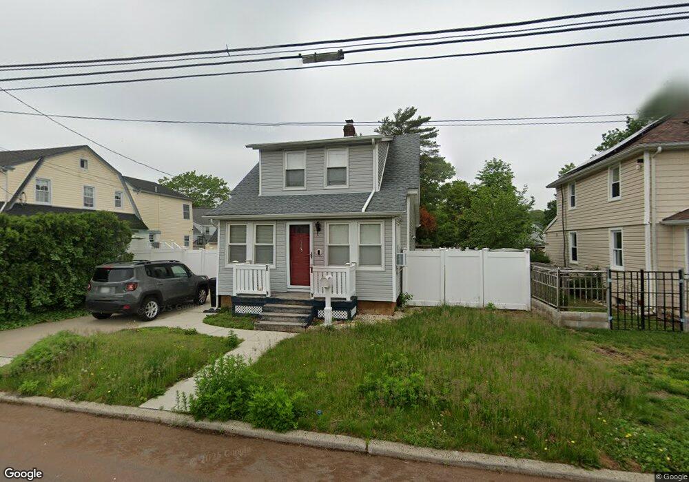
534 Mulberry Ln West Hempstead, NY 11552
Estimated Value: $549,000 - $644,809
2
Beds
2
Baths
1,036
Sq Ft
$576/Sq Ft
Est. Value
About This Home
This home is located at 534 Mulberry Ln, West Hempstead, NY 11552 and is currently estimated at $596,905, approximately $576 per square foot. 534 Mulberry Ln is a home located in Nassau County with nearby schools including Chestnut Street School, West Hempstead Secondary School, and Hebrew Academy of Nassau County (HANC).
Ownership History
Date
Name
Owned For
Owner Type
Purchase Details
Closed on
Jun 24, 2013
Sold by
Buehre Donna Marie and Molter Donna Marie
Bought by
Ocasio Argenis and Ocasio Anna
Current Estimated Value
Home Financials for this Owner
Home Financials are based on the most recent Mortgage that was taken out on this home.
Original Mortgage
$262,163
Outstanding Balance
$193,841
Interest Rate
4.4%
Mortgage Type
FHA
Estimated Equity
$403,064
Purchase Details
Closed on
Nov 11, 2009
Sold by
Buehre Donna Marie and Molter Donna Marie
Bought by
Estate Of James L Molter and Buehre Donna Marie
Create a Home Valuation Report for This Property
The Home Valuation Report is an in-depth analysis detailing your home's value as well as a comparison with similar homes in the area
Home Values in the Area
Average Home Value in this Area
Purchase History
| Date | Buyer | Sale Price | Title Company |
|---|---|---|---|
| Ocasio Argenis | $267,000 | -- | |
| Estate Of James L Molter | -- | -- |
Source: Public Records
Mortgage History
| Date | Status | Borrower | Loan Amount |
|---|---|---|---|
| Open | Ocasio Argenis | $262,163 |
Source: Public Records
Tax History Compared to Growth
Tax History
| Year | Tax Paid | Tax Assessment Tax Assessment Total Assessment is a certain percentage of the fair market value that is determined by local assessors to be the total taxable value of land and additions on the property. | Land | Improvement |
|---|---|---|---|---|
| 2025 | $10,458 | $412 | $222 | $190 |
| 2024 | $3,256 | $412 | $222 | $190 |
| 2023 | $8,653 | $414 | $223 | $191 |
| 2022 | $8,653 | $412 | $222 | $190 |
| 2021 | $10,719 | $409 | $220 | $189 |
| 2020 | $7,722 | $485 | $484 | $1 |
| 2019 | $7,456 | $519 | $447 | $72 |
| 2018 | $7,503 | $554 | $0 | $0 |
| 2017 | $5,607 | $653 | $562 | $91 |
| 2016 | $8,752 | $653 | $562 | $91 |
| 2015 | $2,925 | $653 | $562 | $91 |
| 2014 | $2,925 | $653 | $562 | $91 |
| 2013 | $2,740 | $653 | $562 | $91 |
Source: Public Records
Map
Nearby Homes
- 513 Washington Ave
- 321 Oakford St
- 596 Lincoln Ave
- 647 Jennings Ave
- 757 Harrison St
- 467 Susan Ct
- 629 Park Ave
- 639 Robin Ct
- 686 Tanwood Dr
- 815 Sunshine Ave
- 635 Hempstead Ave
- 853 Arthur St
- 590 Langley Ave
- 613 Adams Ave
- 518 Nassau Blvd
- 55 Melvin Ave
- 899 Cleveland St
- 841 Woodfield Rd
- 537 Madison Ave
- 582 Gaynor Place
- 528 Mulberry Ln
- 540 Mulberry Ln
- 427 Maple St
- 522 Mulberry Ln
- 419 Maple St
- 516 Mulberry Ln
- 410 Lopez Dr
- 544 Mulberry Ln
- 501 Maple St
- 413 Maple St
- 428 Maple St
- 510 Mulberry Ln
- 502 Greenwood Ct
- 0 Dogwood Ave Unit 2876458
- 14421 Old Sheridan St
- 217 Hemp Gardens Dr
- 408 Lopez Dr
- 502 Maple St
- 2767 Schurz Ave
- Lot #52 Ossippe Rd