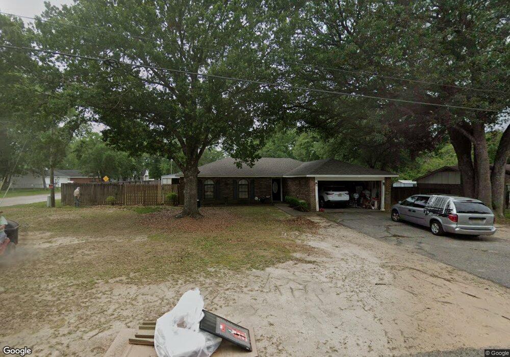
534 Scott Dr Saraland, AL 36571
Estimated Value: $200,313 - $230,000
3
Beds
2
Baths
1,400
Sq Ft
$155/Sq Ft
Est. Value
About This Home
This home is located at 534 Scott Dr, Saraland, AL 36571 and is currently estimated at $216,328, approximately $154 per square foot. 534 Scott Dr is a home located in Mobile County with nearby schools including Saraland Elementary School, Nelson Leon Adams Middle School/Saraland Middle School, and Saraland High School.
Ownership History
Date
Name
Owned For
Owner Type
Purchase Details
Closed on
Feb 23, 2009
Sold by
Moore Lucas R
Bought by
Cogar Larry M and Cogar Denise L
Current Estimated Value
Home Financials for this Owner
Home Financials are based on the most recent Mortgage that was taken out on this home.
Original Mortgage
$125,092
Outstanding Balance
$79,119
Interest Rate
5.03%
Mortgage Type
FHA
Estimated Equity
$137,209
Purchase Details
Closed on
Mar 5, 2008
Sold by
Warren Matthew A
Bought by
Moore Lucas R
Home Financials for this Owner
Home Financials are based on the most recent Mortgage that was taken out on this home.
Original Mortgage
$120,607
Interest Rate
5.63%
Mortgage Type
FHA
Purchase Details
Closed on
Oct 17, 2003
Sold by
Howard Bennie C
Bought by
Warren Matthew A
Home Financials for this Owner
Home Financials are based on the most recent Mortgage that was taken out on this home.
Original Mortgage
$84,194
Interest Rate
6.45%
Mortgage Type
FHA
Create a Home Valuation Report for This Property
The Home Valuation Report is an in-depth analysis detailing your home's value as well as a comparison with similar homes in the area
Home Values in the Area
Average Home Value in this Area
Purchase History
| Date | Buyer | Sale Price | Title Company |
|---|---|---|---|
| Cogar Larry M | $127,400 | None Available | |
| Moore Lucas R | $122,500 | Reli Inc | |
| Warren Matthew A | $85,194 | -- |
Source: Public Records
Mortgage History
| Date | Status | Borrower | Loan Amount |
|---|---|---|---|
| Open | Cogar Larry M | $125,092 | |
| Previous Owner | Moore Lucas R | $120,607 | |
| Previous Owner | Warren Matthew A | $84,194 |
Source: Public Records
Tax History Compared to Growth
Tax History
| Year | Tax Paid | Tax Assessment Tax Assessment Total Assessment is a certain percentage of the fair market value that is determined by local assessors to be the total taxable value of land and additions on the property. | Land | Improvement |
|---|---|---|---|---|
| 2024 | $971 | $17,430 | $3,000 | $14,430 |
| 2023 | $751 | $13,730 | $2,640 | $11,090 |
| 2022 | $710 | $13,050 | $2,420 | $10,630 |
| 2021 | $615 | $11,450 | $2,200 | $9,250 |
| 2020 | $615 | $11,450 | $2,200 | $9,250 |
| 2019 | $601 | $11,220 | $0 | $0 |
| 2018 | $601 | $11,220 | $0 | $0 |
| 2017 | $555 | $10,460 | $0 | $0 |
| 2016 | $542 | $10,240 | $0 | $0 |
| 2013 | -- | $11,060 | $0 | $0 |
Source: Public Records
Map
Nearby Homes
- 159 Courtaulds Ave
- 832 Shelton Beach Rd
- 205 Stauffer Ave
- 0 Joaneen Dr Unit 7576451
- 711 Ann St
- 0 Shelton Beach Rd Unit 7618795
- 503 Shelton Beach Rd
- 1019 Joaneen Dr
- 804 Myron Ave
- 129 Melinda Dr
- 30 Melinda Dr
- 1121 Joaneen Dr
- 253 Autumn Dr
- 234 Autumn Dr
- 20 Robbie Ln
- 0 Lincoln St
- 820 James St
- 827 James St
- 505 Norton Ave
- 325 Bryant Ct