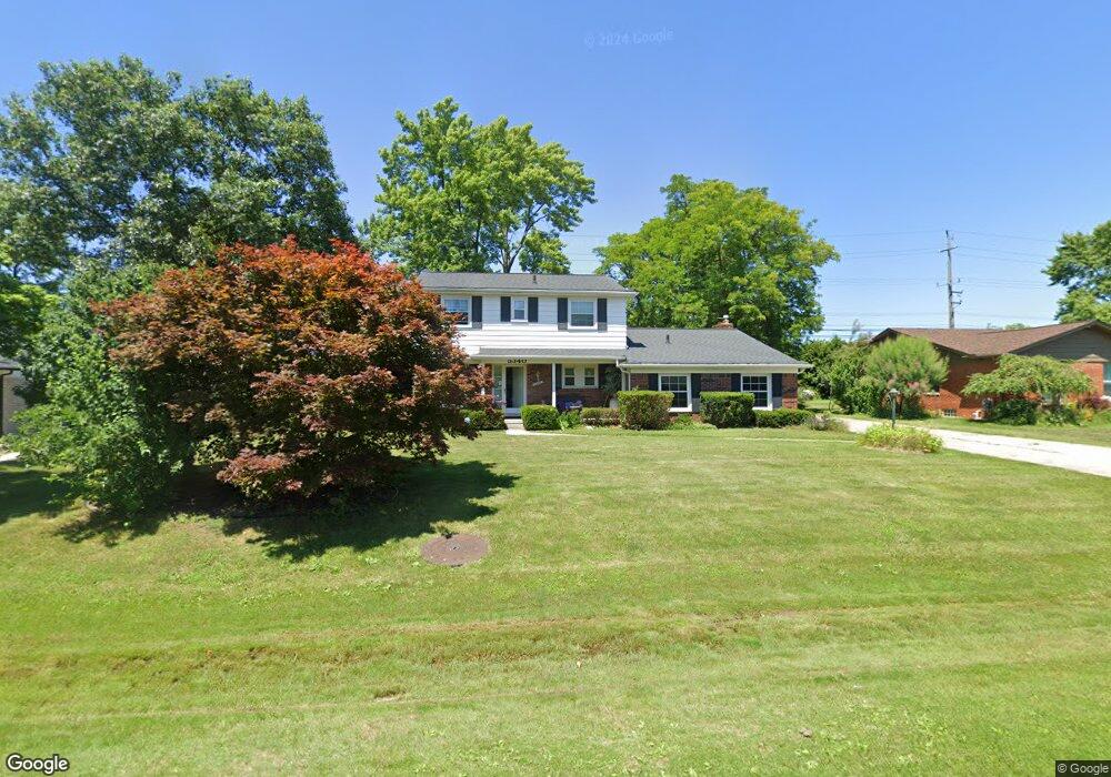
5340 Centerbrook Dr West Bloomfield, MI 48322
Estimated Value: $399,014 - $460,000
4
Beds
3
Baths
2,069
Sq Ft
$207/Sq Ft
Est. Value
About This Home
This home is located at 5340 Centerbrook Dr, West Bloomfield, MI 48322 and is currently estimated at $427,754, approximately $206 per square foot. 5340 Centerbrook Dr is a home located in Oakland County with nearby schools including Sheiko Elementary School, West Bloomfield Middle School, and Bloomfield Maples Montessori.
Ownership History
Date
Name
Owned For
Owner Type
Purchase Details
Closed on
Jul 22, 2004
Sold by
Kaplan Linda and Kaplan Linda B
Bought by
Weissman Eric and Weissman Sheila
Current Estimated Value
Home Financials for this Owner
Home Financials are based on the most recent Mortgage that was taken out on this home.
Original Mortgage
$49,000
Interest Rate
6.35%
Mortgage Type
Stand Alone Second
Create a Home Valuation Report for This Property
The Home Valuation Report is an in-depth analysis detailing your home's value as well as a comparison with similar homes in the area
Home Values in the Area
Average Home Value in this Area
Purchase History
| Date | Buyer | Sale Price | Title Company |
|---|---|---|---|
| Weissman Eric | $264,150 | Title One Inc |
Source: Public Records
Mortgage History
| Date | Status | Borrower | Loan Amount |
|---|---|---|---|
| Closed | Weissman Eric | $49,000 | |
| Previous Owner | Weissman Eric | $211,320 |
Source: Public Records
Tax History Compared to Growth
Tax History
| Year | Tax Paid | Tax Assessment Tax Assessment Total Assessment is a certain percentage of the fair market value that is determined by local assessors to be the total taxable value of land and additions on the property. | Land | Improvement |
|---|---|---|---|---|
| 2024 | $2,368 | $154,550 | $0 | $0 |
| 2022 | $2,268 | $136,810 | $40,000 | $96,810 |
| 2021 | $3,451 | $128,620 | $0 | $0 |
| 2020 | $2,222 | $127,340 | $34,100 | $93,240 |
| 2018 | $3,323 | $116,290 | $28,150 | $88,140 |
| 2015 | -- | $94,230 | $0 | $0 |
| 2014 | -- | $84,310 | $0 | $0 |
| 2011 | -- | $75,650 | $0 | $0 |
Source: Public Records
Map
Nearby Homes
- 6564 Alderley Way
- 6545 Post Oak Dr
- 6882 Post Oak Dr
- 5764 Bloomfield Glens Rd
- 5312 Cambourne Place
- 5815 Bloomfield Glens Rd
- 7209 Stonebrook Rd
- 7251 N Briarcliff Knoll Dr
- 6843 Leslee Crest Dr
- 5241 S Pebblecreek Rd
- 7477 Gramercy Cir Unit 17
- 7479 Gramercy Cir Unit 16
- 7335 Coach Ln
- 6151 Orchard Lake Rd Unit 103
- 5881 Naneva Ct
- 6145 Orchard Lake Rd Unit 204
- 5780 Swan Lake Ct
- 7431 N Briarcliff Knoll Dr
- 3104 Spring St
- 7507 Gramercy Cir
- 5332 Centerbrook Dr
- 5348 Centerbrook Dr
- 5324 Centerbrook Dr
- 5333 Centerbrook Dr
- 5356 Centerbrook Dr
- 5353 Centerbrook Dr
- 5316 Centerbrook Dr
- 6481 Rutledge Park Dr
- 5319 Centerbrook Dr
- 5368 Centerbrook Dr
- 6523 Alderley Way
- 5365 Centerbrook Dr
- 5300 W Maple Rd
- 6516 Post Oak Dr
- 3157 Rutledge Park Ct
- 6465 Rutledge Park Dr
- 5308 Centerbrook Dr
- 6535 Alderley Way
- 6540 Alderley Way
- 6515 Perham Dr