


5344 Wahostsa Trail Hartsel, CO 80449
Estimated payment $83/month
About This Lot
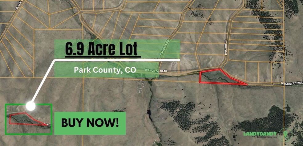
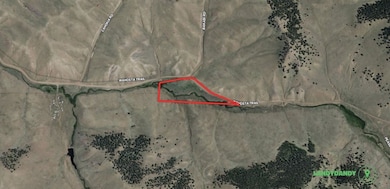
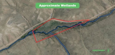
This 6.9-acre parcel in Park County, Colorado, offers ample space ideal for residential, recreational, or agricultural uses. Located near the peaceful area of Hartsel, the property is surrounded by beautiful open landscapes and close to outdoor attractions typical of Park County. Buyer to verify all information and conduct their own due diligence prior to purchase; seller makes no guarantees on land use.
## Property Summary
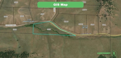
- Acres: 6.9
- County: Park
- State: CO
- Subdivision: ESTATES OF COLORADO
- Zoning: Residential
- Utilities: Off-grid (see utilities section below)
- Annual Taxes: $239.78
- Parcel Number: R0009809
- GPS Center Coordinates: 38.795840454, -105.7100043
- Complete Legal: T14 R74 S30 SW4 ESTATES OF COLORADO UNIT 94 LOT 4806
- Municipality: N/A
## What's Nearby
- Amenities & Attractions (Approximate Distance)
Great Sand Dunes National Park and Preserve
Fort Garland Museum and Cultural Center
Costilla County Museum
Platoro Reservoir (25 mi)
John Mall Park
Sanchez Reservoir and Wildlife Area
Rio Grande National Forest
Costilla County Fairgrounds
La Veta Hot Springs (nearby on the border)
Crestone Needle Mountain Trail
San Luis Valley Regional Airport
Rio Grande Scenic Railroad (runs nearby)
Saguache County Museum (nearby)
Culebra Range
Ute Mountain Tribal Park (regional attraction)
Cuchara Mountain Park
- Closest Towns & Cities (Approximate Distance)
San Luis (County Seat)
Fort Garland (11 mi)
Blanca (22 mi)
Alamosa (28 mi)
La Veta (27 mi)
Walsenburg (40 mi)
Crestone (20 mi)
Saguache (35 mi)
Monte Vista (40 mi)
Zoning Questions
- Can you build on the land?: Yes
- Can you put Mobile Home on Land?: contact County for more information
- Can I Park RV and Live on Property? : No
- Can you Hunt on the land?: contact County for more information
- Can you Camp on the Land?: Yes, camping is authorized as a Temporary Use (T) in the Residential Zone District (R)
- Is there a time limit to build?: contact County for more information
- Does it have direct Road Access: Yes

Property Details
Property Type
- Land
Est. Annual Taxes
- $240
Lot Details
- Current uses include residential single
- Potential uses include residential single
Map
Home Values in the Area
Average Home Value in this Area
Tax History
| Year | Tax Paid | Tax Assessment Tax Assessment Total Assessment is a certain percentage of the fair market value that is determined by local assessors to be the total taxable value of land and additions on the property. | Land | Improvement |
|---|---|---|---|---|
| 2024 | $240 | $5,690 | $5,690 | $0 |
| 2023 | $240 | $5,911 | $5,911 | $0 |
| 2022 | $151 | $3,119 | $3,119 | $0 |
| 2021 | $8 | $59 | $59 | $0 |
| 2020 | $8 | $60 | $60 | $0 |
| 2019 | $8 | $60 | $60 | $0 |
| 2018 | $104 | $60 | $60 | $0 |
| 2017 | $103 | $2,150 | $2,150 | $0 |
| 2016 | $92 | $1,900 | $1,900 | $0 |
| 2015 | $94 | $1,900 | $1,900 | $0 |
| 2014 | $96 | $0 | $0 | $0 |
Property History
| Date | Event | Price | List to Sale | Price per Sq Ft |
|---|---|---|---|---|
| 11/24/2025 11/24/25 | For Sale | $11,999 | -- | -- |
Purchase History
| Date | Type | Sale Price | Title Company |
|---|---|---|---|
| Quit Claim Deed | -- | None Available |
- 1789 Wahosta Trail Unit 3633 & 3634
- 00 Comstick Rd
- 0 Black Beaver Trail
- 4253 Cahokia Rd
- TBD Black Beaver Rd
- 0 Black Beaver Ct Unit S1056971
- 0 Black Beaver Ct Unit REC5937358
- 150 Black Beaver Cir
- 1341 Xtha Trail
- 2343 Xtha Trail
- 000 Wigwam Trail
- 2865 Wigwam Trail
- 694 Black Beaver Cir
- 0 Delaware Rd Unit REC7918040
- 000 Black Beaver Cir
- 0 Uwon Rd Unit S1057525
- 0 Uwon Rd Unit 3594 REC8332948
- 0 Wicaka Trail Unit S1059820
- 0 Wicaka Trail Unit 4146 REC3980891
- 0 Omaha Trail