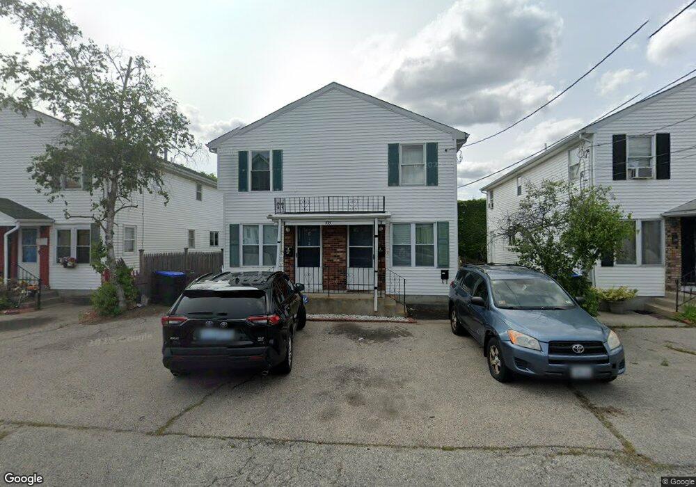
535 Dexter St Providence, RI 02907
West End NeighborhoodEstimated Value: $429,000 - $496,000
4
Beds
4
Baths
2,080
Sq Ft
$225/Sq Ft
Est. Value
About This Home
This home is located at 535 Dexter St, Providence, RI 02907 and is currently estimated at $467,204, approximately $224 per square foot. 535 Dexter St is a home located in Providence County with nearby schools including Asa Messer Elementary School, Charles N. Fortes Elementary School, and Alfred Lima Sr. Elementary School.
Ownership History
Date
Name
Owned For
Owner Type
Purchase Details
Closed on
Sep 2, 2003
Sold by
Freedom Rlty
Bought by
Jimoh Ramu
Current Estimated Value
Home Financials for this Owner
Home Financials are based on the most recent Mortgage that was taken out on this home.
Original Mortgage
$158,746
Interest Rate
5.69%
Mortgage Type
Purchase Money Mortgage
Purchase Details
Closed on
Apr 14, 2003
Sold by
Mackie Stephen C and Fallon Stephen P
Bought by
Freedom Rlty
Home Financials for this Owner
Home Financials are based on the most recent Mortgage that was taken out on this home.
Original Mortgage
$488,000
Interest Rate
5.86%
Mortgage Type
Purchase Money Mortgage
Create a Home Valuation Report for This Property
The Home Valuation Report is an in-depth analysis detailing your home's value as well as a comparison with similar homes in the area
Home Values in the Area
Average Home Value in this Area
Purchase History
Date | Buyer | Sale Price | Title Company |
---|---|---|---|
Jimoh Ramu | $161,500 | -- | |
Freedom Rlty | $121,000 | -- |
Source: Public Records
Mortgage History
Date | Status | Borrower | Loan Amount |
---|---|---|---|
Open | Freedom Rlty | $141,334 | |
Closed | Freedom Rlty | $158,746 | |
Previous Owner | Freedom Rlty | $488,000 |
Source: Public Records
Tax History Compared to Growth
Tax History
Year | Tax Paid | Tax Assessment Tax Assessment Total Assessment is a certain percentage of the fair market value that is determined by local assessors to be the total taxable value of land and additions on the property. | Land | Improvement |
---|---|---|---|---|
2024 | $6,222 | $339,100 | $71,300 | $267,800 |
2023 | $6,222 | $339,100 | $71,300 | $267,800 |
2022 | $6,287 | $353,200 | $71,300 | $281,900 |
2021 | $5,217 | $212,400 | $33,200 | $179,200 |
2020 | $5,217 | $212,400 | $33,200 | $179,200 |
2019 | $5,217 | $212,400 | $33,200 | $179,200 |
2018 | $4,724 | $147,800 | $32,900 | $114,900 |
2017 | $4,724 | $147,800 | $32,900 | $114,900 |
2016 | $4,724 | $147,800 | $32,900 | $114,900 |
2015 | $4,363 | $131,800 | $32,900 | $98,900 |
2014 | $4,448 | $131,800 | $32,900 | $98,900 |
2013 | $4,448 | $131,800 | $32,900 | $98,900 |
Source: Public Records
Map
Nearby Homes
- 43 Calder St
- 31 Madison St
- 35 Vineyard St
- 42 Chambers St
- 133 Burnett St Unit 135
- 716 Potters Ave
- 31 Carter St Unit 33
- 561 Potters Ave
- 13 Halton St
- 27 Carter St
- 10 Calhoun Ave
- 199 Linwood Ave
- 21 Noyes Ave
- 116 Waldo St
- 38 Mawney St
- 133 Linwood Ave
- 137 Stanwood St
- 131 Mitchell St
- 195 Bellevue Ave
- 828 Cranston St