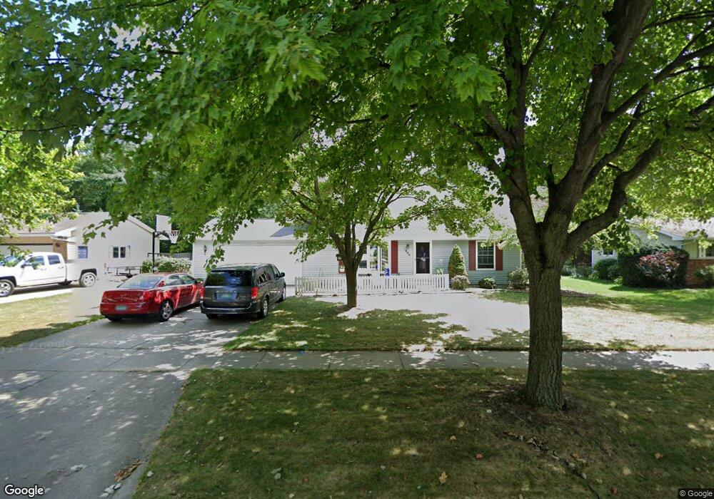
535 Franconian Dr E Frankenmuth, MI 48734
Estimated Value: $294,913 - $408,000
--
Bed
1
Bath
1,606
Sq Ft
$216/Sq Ft
Est. Value
About This Home
This home is located at 535 Franconian Dr E, Frankenmuth, MI 48734 and is currently estimated at $347,228, approximately $216 per square foot. 535 Franconian Dr E is a home located in Saginaw County with nearby schools including List Elementary, E.F. Rittmueller Middle School, and Frankenmuth High School.
Ownership History
Date
Name
Owned For
Owner Type
Purchase Details
Closed on
Jul 20, 2013
Sold by
Liebknecht Wesley R and Liebknecht Patrice A
Bought by
Felten Daniel L and Felten Julie K
Current Estimated Value
Home Financials for this Owner
Home Financials are based on the most recent Mortgage that was taken out on this home.
Original Mortgage
$148,400
Outstanding Balance
$109,786
Interest Rate
4.49%
Mortgage Type
New Conventional
Estimated Equity
$237,442
Purchase Details
Closed on
Oct 31, 1985
Create a Home Valuation Report for This Property
The Home Valuation Report is an in-depth analysis detailing your home's value as well as a comparison with similar homes in the area
Home Values in the Area
Average Home Value in this Area
Purchase History
| Date | Buyer | Sale Price | Title Company |
|---|---|---|---|
| Felten Daniel L | $185,500 | -- | |
| -- | $68,900 | -- |
Source: Public Records
Mortgage History
| Date | Status | Borrower | Loan Amount |
|---|---|---|---|
| Open | Felten Daniel L | $148,400 |
Source: Public Records
Tax History Compared to Growth
Tax History
| Year | Tax Paid | Tax Assessment Tax Assessment Total Assessment is a certain percentage of the fair market value that is determined by local assessors to be the total taxable value of land and additions on the property. | Land | Improvement |
|---|---|---|---|---|
| 2025 | $3,313 | $135,900 | $0 | $0 |
| 2024 | $1,838 | $128,900 | $0 | $0 |
| 2023 | $2,141 | $122,900 | $0 | $0 |
| 2022 | $2,825 | $110,900 | $0 | $0 |
| 2021 | $2,606 | $94,200 | $0 | $0 |
| 2020 | $2,554 | $88,900 | $0 | $0 |
| 2019 | $2,446 | $83,100 | $0 | $0 |
| 2018 | $1,657 | $79,500 | $0 | $0 |
| 2017 | $2,214 | $79,600 | $0 | $0 |
| 2016 | $2,191 | $74,600 | $0 | $0 |
| 2014 | -- | $64,500 | $0 | $45,200 |
| 2013 | -- | $64,100 | $0 | $0 |
Source: Public Records
Map
Nearby Homes
- 249 Churchgrove Rd
- 622 W Schleier St
- 456 Groveland Dr
- 53 Pine Grove Dr
- 2 Wilshire Dr Unit A4
- 11 Cambridge Park
- 7 Rupprecht Ct
- 6 Rupprecht Ct
- 640 Heine St
- 113 Beyerlein St
- 2 Mary Lane Ct
- 10 Harlan Ct
- 5 Mission Ridge
- V/L S Dehmel Rd
- 10487 Roedel Rd
- 327 Kern St
- 000 W Tuscola St
- 230 E Genesee St
- 405 Nickless St
- 1 Sunburst Ct
- 525 Franconian Dr E
- 543 Franconian Dr E
- 521 Franconian Dr E
- 532 Franconian Dr E
- 551 Franconian Dr E
- 524 Franconian Dr E
- 540 Franconian Dr E
- 548 Franconian Dr E
- 559 Franconian Dr E
- 512 Franconian Dr E
- 507 Franconian Dr E
- 556 Franconian Dr E
- 358 Franconian Dr N
- 493 Franconian Dr E
- 348 Franconian Dr N
- 564 Franconian Dr E
- 480 Franconian Dr E
- 577 Franconian Dr E
- 479 Franconian Dr E
- 359 Franconian Dr N