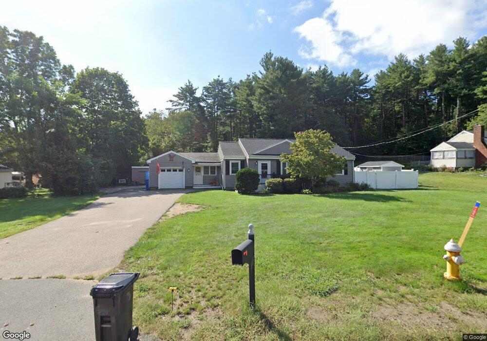
535 West St Wrentham, MA 02093
Sheldonville NeighborhoodEstimated Value: $591,000 - $651,000
2
Beds
1
Bath
1,981
Sq Ft
$320/Sq Ft
Est. Value
About This Home
This home is located at 535 West St, Wrentham, MA 02093 and is currently estimated at $634,623, approximately $320 per square foot. 535 West St is a home located in Norfolk County with nearby schools including Delaney Elementary School, Charles E Roderick, and Mercymount Country Day School.
Ownership History
Date
Name
Owned For
Owner Type
Purchase Details
Closed on
Apr 30, 2015
Sold by
Porazzo Nicholas J and Byrnes Adam W
Bought by
Porazzo Nicholas J and Porazzo Haley
Current Estimated Value
Purchase Details
Closed on
Sep 29, 2006
Sold by
Fiumara Salvatore J
Bought by
Byrnes Adam and Porazzo Nicholas J
Home Financials for this Owner
Home Financials are based on the most recent Mortgage that was taken out on this home.
Original Mortgage
$256,000
Interest Rate
6.52%
Mortgage Type
Purchase Money Mortgage
Purchase Details
Closed on
Aug 17, 2006
Sold by
Boulanger Anne M and Molloy Camille E
Bought by
Fiumara Salvatore J
Home Financials for this Owner
Home Financials are based on the most recent Mortgage that was taken out on this home.
Original Mortgage
$256,000
Interest Rate
6.52%
Mortgage Type
Purchase Money Mortgage
Purchase Details
Closed on
Feb 10, 2005
Sold by
Fiumara Salvatore J
Bought by
Boulanger Ann M and Molloy Camille E
Create a Home Valuation Report for This Property
The Home Valuation Report is an in-depth analysis detailing your home's value as well as a comparison with similar homes in the area
Home Values in the Area
Average Home Value in this Area
Purchase History
| Date | Buyer | Sale Price | Title Company |
|---|---|---|---|
| Porazzo Nicholas J | -- | -- | |
| Byrnes Adam | $320,000 | -- | |
| Fiumara Salvatore J | -- | -- | |
| Boulanger Ann M | -- | -- |
Source: Public Records
Mortgage History
| Date | Status | Borrower | Loan Amount |
|---|---|---|---|
| Previous Owner | Byrnes Adam | $256,000 | |
| Previous Owner | Byrnes Adam | $48,000 |
Source: Public Records
Tax History Compared to Growth
Tax History
| Year | Tax Paid | Tax Assessment Tax Assessment Total Assessment is a certain percentage of the fair market value that is determined by local assessors to be the total taxable value of land and additions on the property. | Land | Improvement |
|---|---|---|---|---|
| 2025 | $6,911 | $596,300 | $249,300 | $347,000 |
| 2024 | $6,448 | $537,300 | $249,300 | $288,000 |
| 2023 | $6,345 | $502,800 | $226,700 | $276,100 |
| 2022 | $6,493 | $475,000 | $220,600 | $254,400 |
| 2021 | $6,313 | $448,700 | $206,100 | $242,600 |
| 2020 | $5,436 | $381,500 | $157,400 | $224,100 |
| 2019 | $5,111 | $362,000 | $141,600 | $220,400 |
| 2018 | $4,731 | $332,200 | $141,800 | $190,400 |
| 2017 | $3,712 | $260,500 | $139,100 | $121,400 |
| 2016 | $3,629 | $254,100 | $135,100 | $119,000 |
| 2015 | $3,910 | $261,000 | $144,300 | $116,700 |
| 2014 | $3,870 | $252,800 | $138,700 | $114,100 |
Source: Public Records
Map
Nearby Homes
- 50 Green St
- 80 Carriage House Ln
- 440 Chestnut St
- 1204 South St
- 1222 South St
- 19 Chestnut Lot 0
- 955 Summer St
- 11 Amber Dr
- 791 South St Unit 5
- 4 Munroe Dr
- 12 Grant St
- Lot 1 - Blueberry 2 Car Plan at King Philip Estates
- Lot 8 - Blueberry 2 Car Plan at King Philip Estates
- Lot 5 - Hughes 2 car Plan at King Philip Estates
- Lot 6 - Blueberry 3 Car Plan at King Philip Estates
- Lot 2 - Camden 2 Car Plan at King Philip Estates
- Lot 7 - Cedar Plan at King Philip Estates
- Lot 4 - Hemingway 2 Car Plan at King Philip Estates
- Lot 3 - Blueberry 2 Car Plan at King Philip Estates
- 387 South St