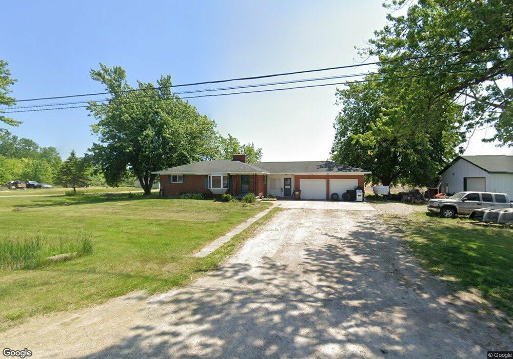
5357 Scofield Carleton Rd Carleton, MI 48117
Estimated Value: $248,000 - $273,209
3
Beds
1
Bath
1,008
Sq Ft
$263/Sq Ft
Est. Value
About This Home
This home is located at 5357 Scofield Carleton Rd, Carleton, MI 48117 and is currently estimated at $265,052, approximately $262 per square foot. 5357 Scofield Carleton Rd is a home located in Monroe County with nearby schools including Airport Senior High School, St. Patrick Elementary School, and Carleton Community Baptist.
Ownership History
Date
Name
Owned For
Owner Type
Purchase Details
Closed on
Apr 18, 2017
Sold by
Lancaster Douglas and Lancaster Diana
Bought by
Lancaster Douglas L and Lancaster Diana L
Current Estimated Value
Purchase Details
Closed on
Oct 21, 2014
Sold by
Lancaster Douglas and Lancaster Diana
Bought by
Lancaster Douglas and Lancaster Diana
Purchase Details
Closed on
Jun 12, 2014
Sold by
Lancaster Deborah L
Bought by
Lancaster Douglas and Lancaster Diana
Create a Home Valuation Report for This Property
The Home Valuation Report is an in-depth analysis detailing your home's value as well as a comparison with similar homes in the area
Purchase History
| Date | Buyer | Sale Price | Title Company |
|---|---|---|---|
| Lancaster Douglas L | -- | None Available | |
| Lancaster Douglas | -- | None Available | |
| Lancaster Douglas | -- | None Available |
Source: Public Records
Tax History
| Year | Tax Paid | Tax Assessment Tax Assessment Total Assessment is a certain percentage of the fair market value that is determined by local assessors to be the total taxable value of land and additions on the property. | Land | Improvement |
|---|---|---|---|---|
| 2025 | $841 | $122,600 | $18,350 | $104,250 |
| 2024 | $816 | $113,800 | $0 | $0 |
| 2023 | $777 | $93,650 | $0 | $0 |
| 2022 | $2,966 | $93,650 | $0 | $0 |
| 2021 | $2,864 | $86,250 | $0 | $0 |
| 2020 | $2,825 | $74,850 | $0 | $0 |
| 2019 | $2,786 | $74,850 | $0 | $0 |
| 2018 | $2,714 | $72,800 | $0 | $0 |
| 2017 | $2,525 | $65,050 | $0 | $0 |
| 2016 | $2,499 | $65,050 | $0 | $0 |
| 2015 | $2,355 | $58,300 | $0 | $0 |
| 2014 | $2,355 | $58,300 | $0 | $0 |
| 2013 | $2,198 | $57,500 | $0 | $0 |
Source: Public Records
Map
Nearby Homes
- 13680 Martinsville Rd
- 5571 Zink Rd
- 0 Hivon Rd
- 8705 Steffas Rd
- 13498 Exeter Rd
- 9601 Exeter Rd
- 5942 Bluebush Rd
- 28710 Sumpter Rd
- 12259 Eldora St
- 12464 Maxwell Rd
- 9306 Raisin St
- 1405 Cedarcrest Dr
- 12361 Spencer Ln
- 8785 Sams Dr Unit 8793
- 8757- 8765 Sams
- 12850 Crane St
- 8085 W Newburg Rd
- 12751 Jones St
- 3290 Gruber Rd
- 7844 Kreps Dr
- 5405 Scofield Carleton Rd
- 5337 Scofield Carleton Rd
- 5417 Scofield Carleton Rd
- 5263 Scofield Carleton Rd
- 5473 Scofield Carleton Rd
- 5205 Scofield Carleton Rd
- 11523 Martinsville Rd
- 5505 Scofield Carleton Rd
- 5535 Scofield Carleton Rd
- 11489 Martinsville Rd
- 5255 Scofield Carleton Rd
- 11489 Martinsville Rd
- 5151 Scofield Carleton Rd
- 5534 Scofield Carleton Rd
- 5150 Scofield Carleton Rd
- 11550 Martinsville Rd
- 5424 Scofield Carleton Rd
- 5424 Scofield Carleton Rd
- 5424 Scofield Carleton Rd
- 11455 Martinsville Rd
Your Personal Tour Guide
Ask me questions while you tour the home.