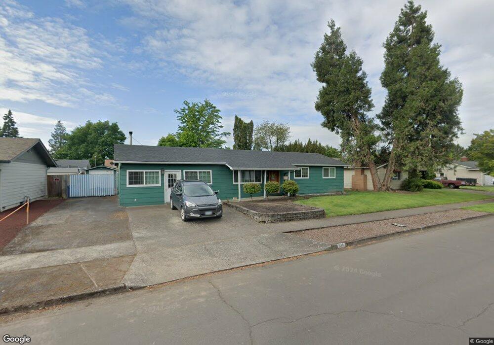
536 Durham Ave Eugene, OR 97404
Santa Clara NeighborhoodEstimated Value: $343,000 - $379,113
3
Beds
2
Baths
1,464
Sq Ft
$242/Sq Ft
Est. Value
About This Home
This home is located at 536 Durham Ave, Eugene, OR 97404 and is currently estimated at $354,778, approximately $242 per square foot. 536 Durham Ave is a home located in Lane County with nearby schools including Spring Creek Elementary School, Madison Middle School, and North Eugene High School.
Ownership History
Date
Name
Owned For
Owner Type
Purchase Details
Closed on
Jul 10, 2012
Sold by
Federal National Mortgage Association
Bought by
Perales Tapia Alma D
Current Estimated Value
Home Financials for this Owner
Home Financials are based on the most recent Mortgage that was taken out on this home.
Original Mortgage
$149,737
Outstanding Balance
$101,927
Interest Rate
3.53%
Mortgage Type
FHA
Estimated Equity
$252,851
Purchase Details
Closed on
Jul 19, 2011
Sold by
Edwards Chester L
Bought by
Federal National Mortgage Association
Purchase Details
Closed on
Apr 17, 2008
Sold by
Edwards Chester L and Edwards La Rayne
Bought by
Edwards Chester L
Home Financials for this Owner
Home Financials are based on the most recent Mortgage that was taken out on this home.
Original Mortgage
$307,500
Interest Rate
3.13%
Mortgage Type
Reverse Mortgage Home Equity Conversion Mortgage
Create a Home Valuation Report for This Property
The Home Valuation Report is an in-depth analysis detailing your home's value as well as a comparison with similar homes in the area
Home Values in the Area
Average Home Value in this Area
Purchase History
| Date | Buyer | Sale Price | Title Company |
|---|---|---|---|
| Perales Tapia Alma D | $130,000 | Evergreen Land Title Co | |
| Federal National Mortgage Association | $148,201 | First American Title | |
| Edwards Chester L | -- | First American Title |
Source: Public Records
Mortgage History
| Date | Status | Borrower | Loan Amount |
|---|---|---|---|
| Open | Perales Tapia Alma D | $149,737 | |
| Previous Owner | Edwards Chester L | $307,500 |
Source: Public Records
Tax History
| Year | Tax Paid | Tax Assessment Tax Assessment Total Assessment is a certain percentage of the fair market value that is determined by local assessors to be the total taxable value of land and additions on the property. | Land | Improvement |
|---|---|---|---|---|
| 2025 | $2,316 | $180,990 | -- | -- |
| 2024 | $2,304 | $175,719 | -- | -- |
| 2023 | $2,304 | $170,601 | $0 | $0 |
| 2022 | $2,166 | $165,633 | $0 | $0 |
| 2021 | $1,987 | $160,809 | $0 | $0 |
| 2020 | $2,025 | $156,126 | $0 | $0 |
| 2019 | $1,949 | $151,579 | $0 | $0 |
| 2018 | $1,791 | $142,879 | $0 | $0 |
| 2017 | $1,651 | $142,879 | $0 | $0 |
| 2016 | $1,540 | $138,717 | $0 | $0 |
| 2015 | $1,478 | $134,677 | $0 | $0 |
| 2014 | $1,387 | $130,754 | $0 | $0 |
Source: Public Records
Map
Nearby Homes
- 2563 York St
- 2568 Dover Dr
- 303 Lenore Loop
- 349 Irving Rd
- 2740 Stark St
- 401 Sterling Dr
- 2785 Alyndale Dr
- 200 Irving Rd
- 193 Santa Clara Ave
- 2488 Northampton
- 2937 Stark St
- 2989 Dahlia Ln
- 1755 Brentwood Ave
- 2923 Maranta St
- 835 Bobolink Ave
- 349 Greenfield Ave
- 1384 David Ave
- 1682 Hemlock St
- 1880 Manihi Dr
- 2484 Crowther Dr
- 542 Durham Ave
- 530 Durham Ave
- 527 Heywood Ave
- 511 Heywood Ave
- 543 Heywood Ave
- 541 Durham Ave
- 552 Durham Ave
- 522 Durham Ave
- 495 Heywood Ave
- 523 Durham Ave
- 559 Heywood Ave
- 2473 Stratford St
- 574 Durham Ave
- 555 Durham Ave
- 2472 Hastings St
- 496 Durham Ave
- 481 Heywood Ave
- 528 Heywood Ave
- 2472 Hasting St
- 575 Heywood Ave
Your Personal Tour Guide
Ask me questions while you tour the home.