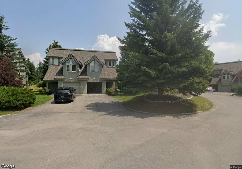
536 Shadowbrook Ln Driggs, ID 83422
Estimated Value: $631,000 - $712,000
Studio
--
Bath
--
Sq Ft
44
Sq Ft Lot
About This Home
This home is located at 536 Shadowbrook Ln, Driggs, ID 83422 and is currently estimated at $685,681. 536 Shadowbrook Ln is a home with nearby schools including Driggs Elementary School, Teton High School, and The Learning Academy Of Teton Valley.
Ownership History
Date
Name
Owned For
Owner Type
Purchase Details
Closed on
Jul 30, 2025
Sold by
Richard C Budde Living Trust and Odenwald Stephen V
Bought by
Jost Nathan and Jost Kristie
Current Estimated Value
Home Financials for this Owner
Home Financials are based on the most recent Mortgage that was taken out on this home.
Original Mortgage
$521,250
Outstanding Balance
$520,794
Interest Rate
6.67%
Mortgage Type
New Conventional
Estimated Equity
$164,887
Purchase Details
Closed on
Aug 19, 2014
Sold by
Budde Richard C
Bought by
Budde Richard C and Richard C Budde Living Trust
Create a Home Valuation Report for This Property
The Home Valuation Report is an in-depth analysis detailing your home's value as well as a comparison with similar homes in the area
Home Values in the Area
Average Home Value in this Area
Purchase History
| Date | Buyer | Sale Price | Title Company |
|---|---|---|---|
| Jost Nathan | -- | Flying S Title And Escrow | |
| Budde Richard C | -- | None Available |
Source: Public Records
Mortgage History
| Date | Status | Borrower | Loan Amount |
|---|---|---|---|
| Open | Jost Nathan | $521,250 |
Source: Public Records
Tax History
| Year | Tax Paid | Tax Assessment Tax Assessment Total Assessment is a certain percentage of the fair market value that is determined by local assessors to be the total taxable value of land and additions on the property. | Land | Improvement |
|---|---|---|---|---|
| 2025 | $2,431 | $697,000 | $50,000 | $647,000 |
| 2024 | $2,431 | $697,000 | $50,000 | $647,000 |
| 2023 | $2,431 | $731,000 | $50,000 | $681,000 |
| 2022 | $2,643 | $633,000 | $40,000 | $593,000 |
| 2021 | $2,357 | $344,000 | $15,000 | $329,000 |
| 2020 | $2,594 | $311,000 | $15,000 | $296,000 |
| 2019 | $2,450 | $299,000 | $15,000 | $284,000 |
| 2018 | $2,267 | $254,600 | $15,000 | $239,600 |
| 2017 | $1,875 | $254,600 | $15,000 | $239,600 |
| 2016 | $1,934 | $221,000 | $15,000 | $206,000 |
| 2015 | $1,838 | $182,300 | $15,000 | $167,300 |
| 2011 | -- | $198,220 | $22,400 | $175,820 |
Source: Public Records
Map
Nearby Homes
- 1135 Wind River Trail
- 564 Palisade Trail
- 532 Palisade Trail
- TBD Ski Hill Rd
- 200 Aspen Meadows Rd
- 976 Couloir Ct
- 954 Farmers Trail
- 1025 Cahuilla Rd
- 1014 Dusty Trail
- 112 Aspen Meadows Rd Unit U36
- 1046 Pawnee Rd
- 1045 Pawnee Rd
- 1030 Iroquois Ave
- 1016 Iroquois Ave
- 624 Easy St
- 570 Easy St
- 280 S 1000 E
- 135 Sagewood Dr
- 1138 Driggs Centre Dr
- 110 Sagewood Dr
- 532 Shadowbrook Ln
- 520 Shadowbrook Ln
- 516 Shadowbrook Ln
- 555 Shadowbrook Ln
- 561 Shadowbrook Ln Unit 9A
- 575 Shadowbrook Ln Unit 10
- 506 Shadowbrook Ln
- 486 Shadowbrook Ln
- 502 Shadowbrook Ln Unit 7
- 502 Shadowbrook Ln
- 482 Shadowbrook Ln
- 1174 Ski Hill Rd
- 91 Powder Valley Ln
- 91 Powder Valley Ln Unit 8
- 91 Powder Valley Ln Unit 14
- 91 Powder Valley Ln Unit 91
- 90 Aspen Dr
- 910 Pdr Vly Unt 6 Rd Unit 6
- 1138 Ski Hill Rd
- 910 Powder Valley Rd Unit UNT32
Your Personal Tour Guide
Ask me questions while you tour the home.