


536 W 650 N American Fork, UT 84003
Estimated payment $3,279/month
Highlights
- Fruit Trees
- Rambler Architecture
- Corner Lot
- Shelley Elementary School Rated A-
- Main Floor Primary Bedroom
- Great Room
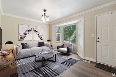
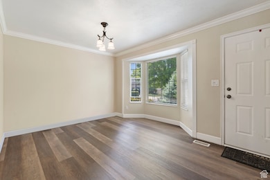
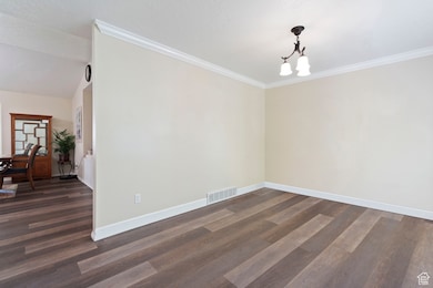
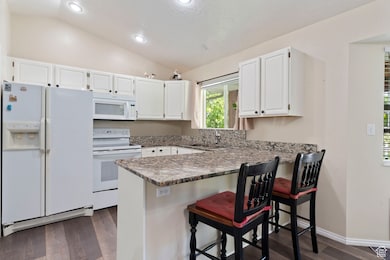
About This Home
Sellers are motivated and willing to contribute toward buyer's closing costs. Beautiful and well-maintained two-story home on a quiet corner lot in a desirable American Fork neighborhood. This 4-bedroom, 3-bath home offers a spacious and functional layout, with main-level living that includes 2 bedrooms, 2 full baths, and a laundry room. The finished basement adds 2 more bedrooms, a full bathroom, and a large storage room. The fully fenced backyard features mature fruit and ornamental trees, a pergola, and a storage shed, creating a peaceful and private outdoor retreat. Enjoy fresh peaches, apricots, pears, and wild cherries in the summer months. Recent upgrades (past 3 to 4 years): New roof, New water heater, Granite countertops, LPV flooring, Fresh interior paint Additional features include: - Fire alarm system - Central vacuum - Water softner - Dimming lights - Automatic sprinklers - Walk-in pantry - Large 2-car garage All appliances included, plus a second fridge and freezer in the garage Excellent location - just minutes from Costco, Walmart, I-15, and local dining, shopping, and recreation. Only 15 minutes to American Fork Canyon, Tibble Fork Reservoir, and world-class skiing at Sundance and nearby resorts. Square footage per appraisal, buyer is advised to get their own measurement. Move-in ready.
Listing Agent
Teresa Peterson
In Depth Realty License #6409656 Listed on: 05/31/2025
Home Details
Home Type
- Single Family
Est. Annual Taxes
- $2,366
Year Built
- Built in 1997
Lot Details
- 9,148 Sq Ft Lot
- Partially Fenced Property
- Landscaped
- Corner Lot
- Sprinkler System
- Fruit Trees
- Mature Trees
- Vegetable Garden
- Property is zoned Single-Family
Parking
- 2 Car Garage
- 4 Open Parking Spaces
Home Design
- Rambler Architecture
- Brick Exterior Construction
Interior Spaces
- 2,345 Sq Ft Home
- 2-Story Property
- Central Vacuum
- Ceiling Fan
- Double Pane Windows
- Blinds
- Great Room
- Carpet
- Basement Fills Entire Space Under The House
- Fire and Smoke Detector
Kitchen
- Walk-In Pantry
- Free-Standing Range
- Microwave
- Freezer
- Granite Countertops
Bedrooms and Bathrooms
- 4 Bedrooms | 2 Main Level Bedrooms
- Primary Bedroom on Main
- Walk-In Closet
- 3 Full Bathrooms
Laundry
- Laundry Room
- Dryer
- Washer
Outdoor Features
- Covered Patio or Porch
- Storage Shed
- Outbuilding
Schools
- Shelley Elementary School
- American Fork Middle School
- American Fork High School
Utilities
- Central Heating and Cooling System
- Natural Gas Connected
Community Details
- No Home Owners Association
- Orchard Hills South Subdivision
Listing and Financial Details
- Assessor Parcel Number 48-202-0005
Map
Home Values in the Area
Average Home Value in this Area
Tax History
| Year | Tax Paid | Tax Assessment Tax Assessment Total Assessment is a certain percentage of the fair market value that is determined by local assessors to be the total taxable value of land and additions on the property. | Land | Improvement |
|---|---|---|---|---|
| 2025 | $2,367 | $524,400 | $220,700 | $303,700 |
| 2024 | $2,367 | $262,955 | $0 | $0 |
| 2023 | $2,215 | $260,920 | $0 | $0 |
| 2022 | $2,370 | $275,550 | $0 | $0 |
| 2021 | $2,028 | $368,300 | $158,400 | $209,900 |
| 2020 | $1,897 | $334,000 | $141,400 | $192,600 |
| 2019 | $1,704 | $310,300 | $130,800 | $179,500 |
| 2018 | $1,637 | $285,100 | $123,700 | $161,400 |
| 2017 | $1,528 | $143,660 | $0 | $0 |
| 2016 | $1,533 | $133,870 | $0 | $0 |
| 2015 | $1,477 | $122,375 | $0 | $0 |
| 2014 | $1,328 | $108,570 | $0 | $0 |
Property History
| Date | Event | Price | List to Sale | Price per Sq Ft |
|---|---|---|---|---|
| 06/30/2025 06/30/25 | Price Changed | $579,000 | -3.3% | $247 / Sq Ft |
| 05/31/2025 05/31/25 | For Sale | $599,000 | -- | $255 / Sq Ft |
Purchase History
| Date | Type | Sale Price | Title Company |
|---|---|---|---|
| Warranty Deed | -- | Meridian Title | |
| Warranty Deed | -- | Meridian Title | |
| Interfamily Deed Transfer | -- | First American Title Ins Co | |
| Interfamily Deed Transfer | -- | None Available | |
| Interfamily Deed Transfer | -- | None Available | |
| Warranty Deed | -- | Provo Land Title Co | |
| Interfamily Deed Transfer | -- | Affiliated First Title | |
| Warranty Deed | -- | -- |
Mortgage History
| Date | Status | Loan Amount | Loan Type |
|---|---|---|---|
| Open | $60,000 | Credit Line Revolving | |
| Previous Owner | $272,540 | VA | |
| Previous Owner | $255,151 | VA | |
| Previous Owner | $141,600 | No Value Available | |
| Previous Owner | $124,686 | FHA |
Source: UtahRealEstate.com
MLS Number: 2088776
APN: 48-202-0005
Disclaimer: Certain information contained herein is derived from information provided by parties other than Homes.com. All information provided is deemed reliable, but is not guaranteed to be accurate and should be independently verified.
![]() IDX information is provided exclusively for consumers’ personal, non-commercial use, that it may not be used for any purpose other than to identify prospective properties consumers may be interested in purchasing, and that the data is deemed reliable but is not guaranteed accurate by the MLS. Licensor is only providing the MLS Content and not other sources of data provided in the Product.
IDX information is provided exclusively for consumers’ personal, non-commercial use, that it may not be used for any purpose other than to identify prospective properties consumers may be interested in purchasing, and that the data is deemed reliable but is not guaranteed accurate by the MLS. Licensor is only providing the MLS Content and not other sources of data provided in the Product.
Based on information from the Wasatch Front Regional Multiple Listing Service, Inc.. All data, including all measurements and calculations of area, is obtained from various sources and has not been, and will not be, verified by broker or the MLS. All information should be independently reviewed and verified for accuracy. Properties may or may not be listed by the office/agent presenting the information.
- 376 W 500 N
- 844 N 580 W
- 540 N 300 W
- 602 W 860 N
- 949 N 780 St W Unit 514
- 974 N 780 St W Unit 509
- 962 N 780 St W Unit 508
- 916 N 780 St W Unit 501
- 914 N 400 W Unit A
- 356 N 480 W
- 822 W 800 St N Unit LOT319
- 3667 W 950 Cir N Unit 217
- 3729 W 950 Cir N Unit 223
- 3687 W 950 Cir N Unit 221
- 3889 W 950 Cir N Unit 366
- 822 N 860 W Unit 317
- 782 N 200 W
- 796 N 200 W
- 984 N 300 W
- 471 W 1040 N
- 628 N 540 W
- 688 W Nicholes Ln
- 270 N Center St Unit 270 N Center St #1
- 200 S 1350 E
- 57 N 900 W
- 79 N 1020 W
- 961 N 200 E
- 976 N 200 E Unit AF basement apartment
- 751 W 200 S
- 299 S 850 W
- 301 S 1100 W
- 174 S 200 E
- 412 S Willow Leaf Rd
- 856 N 600 St E Unit 1
- 304 S 1150 W
- 6225 W 10050 N
- 1055 W 550 S Unit ID1249864P
- 597 S 1080 W
- 104 S 610 E
- 378 W 760 S