Estimated Value: $295,000 - $415,000
3
Beds
2
Baths
2,087
Sq Ft
$176/Sq Ft
Est. Value
About This Home
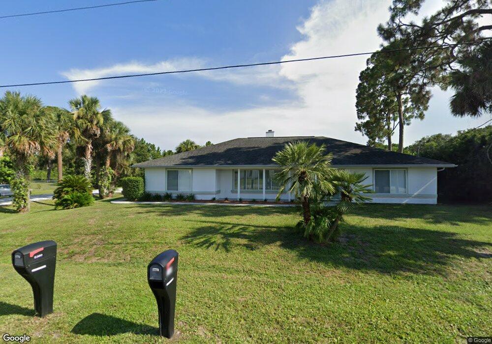
This home is located at 5361 Bridge Rd, Cocoa, FL 32927 and is currently estimated at $368,221, approximately $176 per square foot. 5361 Bridge Rd is a home located in Brevard County with nearby schools including Challenger 7 Elementary School, Space Coast Junior/Senior High School, and East Atlantic Prep of Brevard County.
Ownership History
Date
Name
Owned For
Owner Type
Purchase Details
Closed on
Apr 2, 2007
Sold by
Ainsworth William L
Bought by
Ainsworth Patricia J
Current Estimated Value
Home Financials for this Owner
Home Financials are based on the most recent Mortgage that was taken out on this home.
Original Mortgage
$80,000
Outstanding Balance
$48,237
Interest Rate
6.1%
Estimated Equity
$319,984
Purchase Details
Closed on
Jan 18, 1995
Sold by
Rossi Susan A and Blessington Susan A
Bought by
Ainsworth William L and Ainsworth Patricia J
Create a Home Valuation Report for This Property
The Home Valuation Report is an in-depth analysis detailing your home's value as well as a comparison with similar homes in the area
Home Values in the Area
Average Home Value in this Area
Purchase History
| Date | Buyer | Sale Price | Title Company |
|---|---|---|---|
| Ainsworth Patricia J | -- | Attorney | |
| Ainsworth William L | $12,500 | -- |
Source: Public Records
Mortgage History
| Date | Status | Borrower | Loan Amount |
|---|---|---|---|
| Open | Ainsworth Patricia J | $80,000 |
Source: Public Records
Tax History
| Year | Tax Paid | Tax Assessment Tax Assessment Total Assessment is a certain percentage of the fair market value that is determined by local assessors to be the total taxable value of land and additions on the property. | Land | Improvement |
|---|---|---|---|---|
| 2025 | $1,649 | $116,530 | -- | -- |
| 2024 | $1,609 | $113,250 | -- | -- |
| 2023 | $1,609 | $109,960 | $0 | $0 |
| 2022 | $1,503 | $106,760 | $0 | $0 |
| 2021 | $1,504 | $103,660 | $0 | $0 |
| 2020 | $1,429 | $102,230 | $0 | $0 |
| 2019 | $1,365 | $99,940 | $0 | $0 |
| 2018 | $1,357 | $98,080 | $0 | $0 |
| 2017 | $1,350 | $96,070 | $0 | $0 |
| 2016 | $1,353 | $94,100 | $18,000 | $76,100 |
| 2015 | $1,371 | $93,450 | $15,000 | $78,450 |
| 2014 | $1,373 | $92,710 | $11,000 | $81,710 |
Source: Public Records
Map
Nearby Homes
- 5945 Coker Ave
- 5946 Deer Ln
- 5950 Ackard Ave
- 6020 Cannon Ave
- 5221 Carrick Rd
- 5215 Holden Rd
- 6094 Cardiff Ave
- 5220 Holden Rd
- 5601 Banos Ave
- 5914 Stillwater Ave
- 5720 Flint Rd
- 000 Port Saint John Pkwy
- 6438 Hudson Rd
- No Access Port Saint John Pkwy
- 4905 Bridge Rd
- 4975 Fay Blvd
- 5680 Banos Ave
- 6450 Ember Ave
- 6210 Stillwater Ave
- 6375 Cable Ave
Your Personal Tour Guide
Ask me questions while you tour the home.