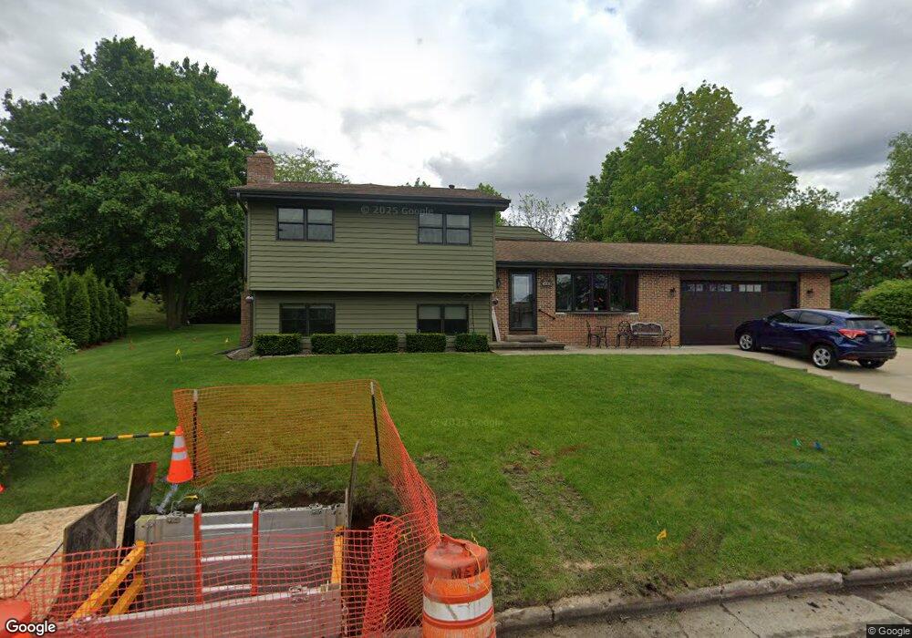
537 Dennis Dr de Forest, WI 53532
Estimated Value: $446,828 - $458,000
4
Beds
2
Baths
1,752
Sq Ft
$258/Sq Ft
Est. Value
About This Home
This home is located at 537 Dennis Dr, de Forest, WI 53532 and is currently estimated at $451,707, approximately $257 per square foot. 537 Dennis Dr is a home located in Dane County with nearby schools including Yahara Elementary School, DeForest Middle School, and DeForest High School.
Ownership History
Date
Name
Owned For
Owner Type
Purchase Details
Closed on
Oct 8, 2025
Sold by
Dykstra Robin A and Kroon Robin A
Bought by
Dykstra Terry S and Dykstra Robin A
Current Estimated Value
Purchase Details
Closed on
Oct 30, 2014
Sold by
Midmoor Investments Llc
Bought by
Kroon Robin A
Home Financials for this Owner
Home Financials are based on the most recent Mortgage that was taken out on this home.
Original Mortgage
$142,465
Interest Rate
4.23%
Mortgage Type
New Conventional
Purchase Details
Closed on
Apr 28, 2006
Sold by
Mcgilton James A and Mcgilton Chung Cha
Bought by
Midmcor Investments Llc
Home Financials for this Owner
Home Financials are based on the most recent Mortgage that was taken out on this home.
Original Mortgage
$152,915
Interest Rate
6.37%
Mortgage Type
Future Advance Clause Open End Mortgage
Create a Home Valuation Report for This Property
The Home Valuation Report is an in-depth analysis detailing your home's value as well as a comparison with similar homes in the area
Home Values in the Area
Average Home Value in this Area
Purchase History
| Date | Buyer | Sale Price | Title Company |
|---|---|---|---|
| Dykstra Terry S | -- | None Listed On Document | |
| Kroon Robin A | $158,300 | None Available | |
| Midmcor Investments Llc | $179,900 | None Available |
Source: Public Records
Mortgage History
| Date | Status | Borrower | Loan Amount |
|---|---|---|---|
| Previous Owner | Kroon Robin A | $142,465 | |
| Previous Owner | Midmcor Investments Llc | $152,915 |
Source: Public Records
Tax History Compared to Growth
Tax History
| Year | Tax Paid | Tax Assessment Tax Assessment Total Assessment is a certain percentage of the fair market value that is determined by local assessors to be the total taxable value of land and additions on the property. | Land | Improvement |
|---|---|---|---|---|
| 2024 | $7,191 | $451,600 | $98,500 | $353,100 |
| 2023 | $7,075 | $422,500 | $98,500 | $324,000 |
| 2021 | $6,812 | $348,900 | $84,600 | $264,300 |
| 2020 | $4,851 | $239,500 | $84,600 | $154,900 |
| 2019 | $4,678 | $234,500 | $77,200 | $157,300 |
| 2018 | $4,088 | $206,500 | $77,200 | $129,300 |
| 2017 | $4,068 | $206,500 | $77,200 | $129,300 |
| 2016 | $4,108 | $206,500 | $77,200 | $129,300 |
| 2015 | $3,897 | $183,200 | $61,200 | $122,000 |
| 2014 | $3,830 | $183,200 | $61,200 | $122,000 |
| 2013 | $3,982 | $183,200 | $61,200 | $122,000 |
Source: Public Records
Map
Nearby Homes
- 408 Iroquois Ct
- 217 Pocahontas Ln
- 107 Carriage Way
- 401 N Stevenson St
- 409 Old Indian Trail
- 216 Sanford Dr
- 524 Park Ave
- 549 Yahara St
- 528 Park Ave
- 520 E Holum St
- 612 Park Ave
- 392 Campbell Hill Ct
- 624 W Mohawk Trail
- 400 Market St
- 620 Acker Pkwy
- 464 Dahl Dr
- 716 E Holum St
- 505 Wild Plum Dr
- 322 Yorktown Rd
- 404 S Cleveland Ave