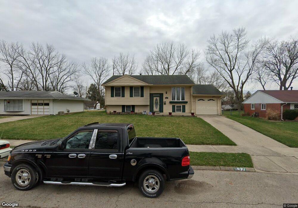
537 Hazelbrook Ave Springfield, OH 45506
Estimated Value: $137,000 - $199,000
3
Beds
2
Baths
1,037
Sq Ft
$150/Sq Ft
Est. Value
About This Home
This home is located at 537 Hazelbrook Ave, Springfield, OH 45506 and is currently estimated at $155,442, approximately $149 per square foot. 537 Hazelbrook Ave is a home located in Clark County with nearby schools including Perrin Woods Elementary School, Hayward Middle School, and Springfield High School.
Ownership History
Date
Name
Owned For
Owner Type
Purchase Details
Closed on
Nov 27, 2019
Sold by
Miller Norman D
Bought by
Miller Cassandra D
Current Estimated Value
Purchase Details
Closed on
Sep 26, 2001
Sold by
Miller Norman D and Davis Cassandra
Bought by
Miller Norman D and Miller Cassandra D
Home Financials for this Owner
Home Financials are based on the most recent Mortgage that was taken out on this home.
Original Mortgage
$119,000
Outstanding Balance
$56,300
Interest Rate
10.53%
Mortgage Type
Purchase Money Mortgage
Estimated Equity
$99,142
Purchase Details
Closed on
May 26, 1994
Create a Home Valuation Report for This Property
The Home Valuation Report is an in-depth analysis detailing your home's value as well as a comparison with similar homes in the area
Home Values in the Area
Average Home Value in this Area
Purchase History
| Date | Buyer | Sale Price | Title Company |
|---|---|---|---|
| Miller Cassandra D | -- | None Available | |
| Miller Norman D | -- | Premier Title Services Inc | |
| -- | $59,900 | -- |
Source: Public Records
Mortgage History
| Date | Status | Borrower | Loan Amount |
|---|---|---|---|
| Open | Miller Norman D | $119,000 |
Source: Public Records
Tax History
| Year | Tax Paid | Tax Assessment Tax Assessment Total Assessment is a certain percentage of the fair market value that is determined by local assessors to be the total taxable value of land and additions on the property. | Land | Improvement |
|---|---|---|---|---|
| 2025 | $1,159 | $37,330 | $5,480 | $31,850 |
| 2024 | $1,160 | $33,170 | $4,930 | $28,240 |
| 2023 | $1,160 | $33,170 | $4,930 | $28,240 |
| 2022 | $1,209 | $33,170 | $4,930 | $28,240 |
| 2021 | $1,005 | $27,450 | $3,520 | $23,930 |
| 2020 | $1,007 | $27,450 | $3,520 | $23,930 |
| 2019 | $1,010 | $27,450 | $3,520 | $23,930 |
| 2018 | $806 | $23,110 | $3,130 | $19,980 |
| 2017 | $806 | $21,172 | $3,126 | $18,046 |
| 2016 | $807 | $21,172 | $3,126 | $18,046 |
| 2015 | $871 | $21,172 | $3,126 | $18,046 |
| 2014 | $867 | $21,172 | $3,126 | $18,046 |
| 2013 | $858 | $21,172 | $3,126 | $18,046 |
Source: Public Records
Map
Nearby Homes
- 518 Hazelbrook Ave
- 1730 Damascus Ave
- 550 W Parkwood Ave
- 2000 Springmont Ave
- 1920 Russell Ave
- 1619 S Center Blvd
- 2140 Shawnee Ave
- 405 W Southern Ave
- 506 W Southern Ave
- 1754 S Fountain Ave
- 311 W Grand Ave
- 326 W Grand Ave
- 1002 S Yellow Springs St
- 1355 S Fountain Ave
- 802 Innisfallen Ave
- 0 W Perrin Ave Unit 1043508
- 0 W Perrin Ave Unit 951292
- 929 S Western Ave
- 410 W Liberty St
- 209 W Liberty St
- 603 Hazelbrook Ave
- 531 Hazelbrook Ave
- 534 W John St
- 600 W John St
- 609 Hazelbrook Ave
- 523 Hazelbrook Ave
- 528 W John St
- 536 Hazelbrook Ave
- 608 W John St
- 532 Hazelbrook Ave
- 602 Hazelbrook Ave
- 519 Hazelbrook Ave
- 615 Hazelbrook Ave
- 522 Hazelbrook Ave
- 608 Hazelbrook Ave
- 520 W John St
- 614 W John St
- 520 Hazelbrook Ave
- 614 Hazelbrook Ave
- 517 Hazelbrook Ave
Your Personal Tour Guide
Ask me questions while you tour the home.