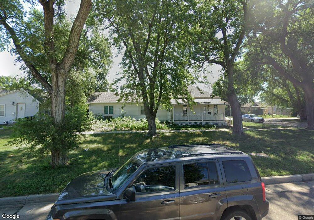
537 S Boston Ave Hastings, NE 68901
Estimated Value: $115,000 - $148,000
2
Beds
2
Baths
1,380
Sq Ft
$96/Sq Ft
Est. Value
About This Home
This home is located at 537 S Boston Ave, Hastings, NE 68901 and is currently estimated at $132,847, approximately $96 per square foot. 537 S Boston Ave is a home located in Adams County with nearby schools including Hastings Senior High School, St. Michael's Preschool & Elementary School, and St. Cecilia High School.
Ownership History
Date
Name
Owned For
Owner Type
Purchase Details
Closed on
Jun 26, 2020
Sold by
Meyer Randall L and Estate Of Anna Marie Meyer
Bought by
Rosenberg Christopher A
Current Estimated Value
Home Financials for this Owner
Home Financials are based on the most recent Mortgage that was taken out on this home.
Original Mortgage
$76,587
Outstanding Balance
$68,038
Interest Rate
3.2%
Mortgage Type
FHA
Estimated Equity
$64,809
Create a Home Valuation Report for This Property
The Home Valuation Report is an in-depth analysis detailing your home's value as well as a comparison with similar homes in the area
Home Values in the Area
Average Home Value in this Area
Purchase History
| Date | Buyer | Sale Price | Title Company |
|---|---|---|---|
| Rosenberg Christopher A | $78,000 | Charter Title |
Source: Public Records
Mortgage History
| Date | Status | Borrower | Loan Amount |
|---|---|---|---|
| Open | Rosenberg Christopher A | $76,587 |
Source: Public Records
Tax History Compared to Growth
Tax History
| Year | Tax Paid | Tax Assessment Tax Assessment Total Assessment is a certain percentage of the fair market value that is determined by local assessors to be the total taxable value of land and additions on the property. | Land | Improvement |
|---|---|---|---|---|
| 2024 | $1,750 | $109,967 | $17,215 | $92,752 |
| 2023 | $2,197 | $106,465 | $17,215 | $89,250 |
| 2022 | $2,398 | $106,465 | $17,215 | $89,250 |
| 2021 | $1,467 | $66,874 | $13,116 | $53,758 |
| 2020 | $1,291 | $59,848 | $13,116 | $46,732 |
| 2019 | $0 | $56,791 | $13,116 | $43,675 |
| 2018 | $0 | $51,300 | $7,625 | $43,675 |
| 2017 | $0 | $51,300 | $0 | $0 |
| 2016 | -- | $47,695 | $7,625 | $40,070 |
| 2011 | -- | $46,155 | $7,625 | $38,530 |
Source: Public Records
Map
Nearby Homes
- 527 S Boston Ave
- 1423 W B St
- 745 S Franklin Ave
- 1140 Renae Ln
- 416 Queen City Ave
- 1142 W H St
- 720 W D St
- 514 S Hastings Ave
- 502 S Woodland Ave
- 1734 W 2nd St
- 310 N Saunders Ave
- 313 Jefferson Ave
- 1002 S Lincoln Ave
- 1011 W 4th St
- 1918 W 3rd St
- 719 S Kansas Ave
- 514 Oswego Ave
- 619 N Briggs Ave
- 1114-1116 W 6th St
- 1911 W 5th St
- 531 S Boston Ave
- 1346 W D St
- 1342 W D St
- 601 S Boston Ave
- 602 S New York Ave
- 604 S New York Ave
- 607 S Boston Ave
- 521 S Boston Ave
- 536 S Boston Ave
- 611 S Boston Ave
- 534 S Boston Ave
- 530 S Boston Ave
- 610 S New York Ave
- 600 S Boston Ave
- 519 S Boston Ave
- 606 S Boston Ave
- 526 S Boston Ave
- 540 S New York Ave
- 530 S New York Ave
- 615 S Boston Ave