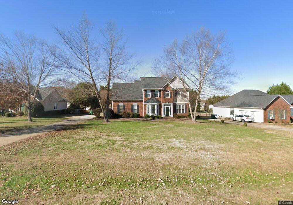
539 Butternut Ln Matthews, NC 28104
Estimated Value: $405,000 - $501,000
3
Beds
3
Baths
2,006
Sq Ft
$219/Sq Ft
Est. Value
About This Home
This home is located at 539 Butternut Ln, Matthews, NC 28104 and is currently estimated at $439,801, approximately $219 per square foot. 539 Butternut Ln is a home located in Union County with nearby schools including Stallings Elementary School, Porter Ridge Middle School, and Porter Ridge High School.
Ownership History
Date
Name
Owned For
Owner Type
Purchase Details
Closed on
Jun 25, 2007
Sold by
Seibert William J and Seibert Patricia W
Bought by
Gould Stephen P and Gould Lidiya
Current Estimated Value
Home Financials for this Owner
Home Financials are based on the most recent Mortgage that was taken out on this home.
Original Mortgage
$160,000
Outstanding Balance
$96,474
Interest Rate
6.1%
Mortgage Type
New Conventional
Estimated Equity
$343,327
Purchase Details
Closed on
Mar 25, 1997
Sold by
Love Construction Company Inc
Bought by
Seibert William J and Wife Patricia W
Purchase Details
Closed on
Feb 19, 1997
Sold by
Old Mill Estates
Bought by
Love Construction Company Inc
Create a Home Valuation Report for This Property
The Home Valuation Report is an in-depth analysis detailing your home's value as well as a comparison with similar homes in the area
Purchase History
| Date | Buyer | Sale Price | Title Company |
|---|---|---|---|
| Gould Stephen P | $215,000 | None Available | |
| Seibert William J | $147,000 | -- | |
| Love Construction Company Inc | $47,000 | -- |
Source: Public Records
Mortgage History
| Date | Status | Borrower | Loan Amount |
|---|---|---|---|
| Open | Gould Stephen P | $160,000 |
Source: Public Records
Tax History
| Year | Tax Paid | Tax Assessment Tax Assessment Total Assessment is a certain percentage of the fair market value that is determined by local assessors to be the total taxable value of land and additions on the property. | Land | Improvement |
|---|---|---|---|---|
| 2025 | $2,519 | $366,300 | $0 | $0 |
| 2024 | $2,343 | $265,400 | $53,600 | $211,800 |
| 2023 | $2,248 | $265,400 | $53,600 | $211,800 |
| 2022 | $2,227 | $265,400 | $53,600 | $211,800 |
| 2021 | $2,225 | $265,400 | $53,600 | $211,800 |
| 2020 | $1,897 | $185,010 | $36,610 | $148,400 |
| 2019 | $1,889 | $185,010 | $36,610 | $148,400 |
| 2018 | $1,889 | $185,010 | $36,610 | $148,400 |
| 2017 | $1,936 | $185,000 | $36,600 | $148,400 |
| 2016 | $1,955 | $185,010 | $36,610 | $148,400 |
| 2015 | $1,974 | $185,010 | $36,610 | $148,400 |
| 2014 | $1,395 | $197,080 | $33,200 | $163,880 |
Source: Public Records
Map
Nearby Homes
- 1060 Mountain Laurel Ct
- 1300 Afternoon Sun Rd
- 1201 Mountain Laurel Ct
- 4006 Scarlet Dr Unit 29
- 2005 Blue Iris Dr
- 1504 Sunflower Field Place
- 3210 Timber Mill Dr
- 5401 Stevens Mill Rd
- 2826 Barnard Castle Ln
- 1419 Vickery Dr
- 219 Falcon Ridge
- 7803 Stinson Hartis Rd
- 5153 Blackberry Ln
- 2909 Oakcroft Dr
- 804 Dogwood Creek Ln
- 0000 White Oak Ln
- 7038 Hyde Park Dr
- 433 Gregan Ct
- 2108 Stallings Rd
- 300 Forest Park Rd
- 545 Butternut Ln
- 531 Butternut Ln
- 227 Houston Blair Rd
- 601 Butternut Ln
- 523 Butternut Ln
- 223 Houston Blair Rd Unit 42
- 219 Houston Blair Rd Unit 43
- 538 Butternut Ln
- 511 Butternut Ln
- 603 Butternut Ln
- 546 Butternut Ln
- 546 Butternut Ln Unit 32
- 530 Butternut Ln
- 215 Houston Blair Rd Unit 44
- 215 Houston Blair Rd
- 522 Butternut Ln
- 600 Butternut Ln
- 505 Butternut Ln
- 514 Butternut Ln
- 211 Houston Blair Rd Unit 45
Your Personal Tour Guide
Ask me questions while you tour the home.