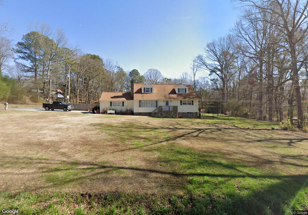
539 Carbondale Rd SW Dalton, GA 30721
Estimated Value: $253,865 - $278,000
4
Beds
2
Baths
1,677
Sq Ft
$160/Sq Ft
Est. Value
About This Home
This home is located at 539 Carbondale Rd SW, Dalton, GA 30721 and is currently estimated at $268,216, approximately $159 per square foot. 539 Carbondale Rd SW is a home located in Whitfield County with nearby schools including Valley Point Elementary School, Valley Point Middle School, and Southeast Whitfield County High School.
Ownership History
Date
Name
Owned For
Owner Type
Purchase Details
Closed on
Aug 24, 2006
Sold by
Not Provided
Bought by
Cleary Charles Pernell
Current Estimated Value
Purchase Details
Closed on
Oct 8, 2004
Sold by
Cleary C Pernell
Bought by
Cleary Kimberly E
Purchase Details
Closed on
Nov 1, 1994
Bought by
Cleary Cleary C and Cleary Kimberly E
Create a Home Valuation Report for This Property
The Home Valuation Report is an in-depth analysis detailing your home's value as well as a comparison with similar homes in the area
Home Values in the Area
Average Home Value in this Area
Purchase History
| Date | Buyer | Sale Price | Title Company |
|---|---|---|---|
| Cleary Charles Pernell | -- | -- | |
| Cleary Kimberly E | -- | -- | |
| Cleary Cleary C | -- | -- |
Source: Public Records
Tax History Compared to Growth
Tax History
| Year | Tax Paid | Tax Assessment Tax Assessment Total Assessment is a certain percentage of the fair market value that is determined by local assessors to be the total taxable value of land and additions on the property. | Land | Improvement |
|---|---|---|---|---|
| 2024 | $2,445 | $88,790 | $5,996 | $82,794 |
| 2023 | $1,669 | $56,579 | $3,327 | $53,252 |
| 2022 | $1,237 | $41,936 | $2,716 | $39,220 |
| 2021 | $1,237 | $41,936 | $2,716 | $39,220 |
| 2020 | $1,279 | $41,936 | $2,716 | $39,220 |
| 2019 | $1,300 | $41,936 | $2,716 | $39,220 |
| 2018 | $1,316 | $41,773 | $2,553 | $39,220 |
| 2017 | $1,317 | $41,773 | $2,553 | $39,220 |
| 2016 | $1,141 | $37,643 | $1,964 | $35,679 |
| 2014 | $1,062 | $39,438 | $3,758 | $35,679 |
| 2013 | -- | $39,437 | $3,758 | $35,679 |
Source: Public Records
Map
Nearby Homes
- 323 Tubman Way
- 674 Eber Rd SE
- 4888 Cline Rd
- 0 Carbondale Rd SW Unit 129966
- 0 Carbondale Rd SW Unit 7574085
- 0 Carbondale Rd SW Unit 130445
- 0 Carbondale Rd SW Unit 1522370
- 0 Carbondale Rd SW Unit 10515867
- 0 Carbondale Rd SW Unit 129726
- 402 W Nance Springs Rd
- 4381 S Dixie Hwy
- 3737 S Dixie Rd
- 73 Acres S Dixie Hwy
- 213 Gwendolyn Lee Ln
- 876 Cline Rd
- 116 Robin Hood Dr
- 122 Robin Hood Dr
- 112 Robin Hood Dr
- 104 W Nance Springs Rd
- 4280 Old Dixie Hwy SE
- 551 Carbondale Rd SW
- 108 Bunker Hill Dr SW
- 559 Carbondale Rd SW
- 731 W Nance Springs Rd SW
- 743 W Nance Springs Rd SW
- 721 W Nance Springs Rd SW
- 730 W Nance Springs Rd SW
- 717 W Nance Springs Rd SW
- 736 W Nance Springs Rd SW
- 573 Carbondale Rd SW
- 573 Carbondale - Hill City
- 726 W Nance Springs Rd SW
- 715 W Nance Springs Rd SW
- 728 W Nance Springs Rd SW
- 722 W Nance Springs Rd SW
- 140 Bunker Hill Dr SW
- 489 Carbondale Rd SW
- 585 Carbondale Rd SW
- 161 Sweetwater Way
- 711 W Nance Springs Rd SW