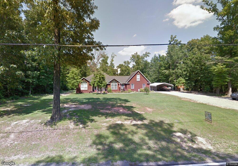
539 Jarrett Rd Hartselle, AL 35640
Estimated Value: $253,000 - $439,000
4
Beds
3
Baths
2,975
Sq Ft
$129/Sq Ft
Est. Value
About This Home
This home is located at 539 Jarrett Rd, Hartselle, AL 35640 and is currently estimated at $382,345, approximately $128 per square foot. 539 Jarrett Rd is a home located in Morgan County with nearby schools including Sparkman Elementary School and Albert P. Brewer High School.
Ownership History
Date
Name
Owned For
Owner Type
Purchase Details
Closed on
Jan 25, 2017
Sold by
Wakefield Steven R
Bought by
Wakefield Christy D
Current Estimated Value
Home Financials for this Owner
Home Financials are based on the most recent Mortgage that was taken out on this home.
Original Mortgage
$171,900
Outstanding Balance
$142,723
Interest Rate
4.3%
Mortgage Type
New Conventional
Estimated Equity
$239,622
Purchase Details
Closed on
Jul 13, 2005
Sold by
Eddy James Kenneth and Eddy Janet Sue
Bought by
Wakefield Christy D and Wakefield Steven R
Create a Home Valuation Report for This Property
The Home Valuation Report is an in-depth analysis detailing your home's value as well as a comparison with similar homes in the area
Home Values in the Area
Average Home Value in this Area
Purchase History
| Date | Buyer | Sale Price | Title Company |
|---|---|---|---|
| Wakefield Christy D | $18,500 | None Available | |
| Wakefield Christy D | -- | None Available |
Source: Public Records
Mortgage History
| Date | Status | Borrower | Loan Amount |
|---|---|---|---|
| Open | Wakefield Christy D | $171,900 |
Source: Public Records
Tax History Compared to Growth
Tax History
| Year | Tax Paid | Tax Assessment Tax Assessment Total Assessment is a certain percentage of the fair market value that is determined by local assessors to be the total taxable value of land and additions on the property. | Land | Improvement |
|---|---|---|---|---|
| 2024 | $1,000 | $28,840 | $1,880 | $26,960 |
| 2023 | $1,025 | $28,080 | $1,740 | $26,340 |
| 2022 | $939 | $26,540 | $1,580 | $24,960 |
| 2021 | $805 | $22,960 | $1,500 | $21,460 |
| 2020 | $790 | $43,160 | $1,500 | $41,660 |
| 2019 | $790 | $22,560 | $0 | $0 |
| 2015 | $690 | $19,880 | $0 | $0 |
| 2014 | $690 | $19,880 | $0 | $0 |
| 2013 | -- | $18,960 | $0 | $0 |
Source: Public Records
Map
Nearby Homes
- 1094 Perkins Wood Rd
- 659 Church Rd
- 10 Jack Thomas Ct
- 337 Perry Ave
- 105 New Center Rd
- 0 Hobb Ward Rd Unit 21414136
- 12.8 acres Hobb Ward Rd
- 53 Slaten Dr
- 60 Acres Cain Rd
- 11 Route 67
- 1 ACRE Highway 67 S
- 16.5 Route 67
- 46 Bluff City Rd
- 275 Cain Rd
- 400 Still Meadow Rd
- 571 Berry Rd
- 480 Wildwood Way
- 199 Peach Tree Rd
- 4664 Route 67
- 142 Griffin Rd
- 532 Jarrett Rd
- 517 Jarrett Rd
- 513 Jarrett Rd
- 556 Jarrett Rd
- 803 Perkins Wood Rd
- 49 Arrowwood Pvt Dr
- 493 Jarrett Rd
- 11 Perkins Wood Rd
- 1767 New Center Rd
- 751 Perkins Wood Rd
- 452 Jarrett Rd
- 0 Perkins Wood Rd
- 45 Alsbrooks Dr
- 846 Perkins Wood Rd
- 9 Alsbrooks Dr
- 37 Alsbrooks Dr
- 880 Perkins Wood Rd
- 740 Perkins Wood Rd
- 898 Perkins Wood Rd
- 12 Saddlebred Pvt Dr