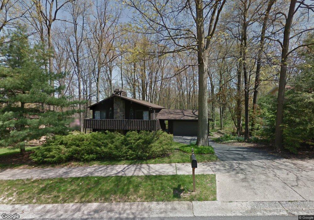
539 Lanceshire Ln State College, PA 16803
Patton NeighborhoodEstimated Value: $390,869 - $455,000
5
Beds
3
Baths
1,932
Sq Ft
$222/Sq Ft
Est. Value
About This Home
This home is located at 539 Lanceshire Ln, State College, PA 16803 and is currently estimated at $428,717, approximately $221 per square foot. 539 Lanceshire Ln is a home located in Centre County with nearby schools including Park Forest Elementary School, Park Forest Middle School, and State College Area High School.
Ownership History
Date
Name
Owned For
Owner Type
Purchase Details
Closed on
Jun 22, 2005
Sold by
Scerbo Francis B
Bought by
Haas Erik J and Swisher Kelly P
Current Estimated Value
Home Financials for this Owner
Home Financials are based on the most recent Mortgage that was taken out on this home.
Original Mortgage
$171,200
Outstanding Balance
$89,204
Interest Rate
5.73%
Mortgage Type
Fannie Mae Freddie Mac
Estimated Equity
$339,513
Create a Home Valuation Report for This Property
The Home Valuation Report is an in-depth analysis detailing your home's value as well as a comparison with similar homes in the area
Home Values in the Area
Average Home Value in this Area
Purchase History
| Date | Buyer | Sale Price | Title Company |
|---|---|---|---|
| Haas Erik J | $215,000 | -- |
Source: Public Records
Mortgage History
| Date | Status | Borrower | Loan Amount |
|---|---|---|---|
| Open | Haas Erik J | $171,200 |
Source: Public Records
Tax History Compared to Growth
Tax History
| Year | Tax Paid | Tax Assessment Tax Assessment Total Assessment is a certain percentage of the fair market value that is determined by local assessors to be the total taxable value of land and additions on the property. | Land | Improvement |
|---|---|---|---|---|
| 2025 | $4,584 | $65,800 | $9,355 | $56,445 |
| 2024 | $4,276 | $65,800 | $9,355 | $56,445 |
| 2023 | $4,276 | $65,800 | $9,355 | $56,445 |
| 2022 | $4,174 | $65,800 | $9,355 | $56,445 |
| 2021 | $4,174 | $65,800 | $9,355 | $56,445 |
| 2020 | $4,174 | $65,800 | $9,355 | $56,445 |
| 2019 | $2,924 | $65,800 | $9,355 | $56,445 |
| 2018 | $4,046 | $65,800 | $9,355 | $56,445 |
| 2017 | $4,001 | $65,800 | $9,355 | $56,445 |
| 2016 | -- | $65,800 | $9,355 | $56,445 |
| 2015 | -- | $65,800 | $9,355 | $56,445 |
| 2014 | -- | $65,800 | $9,355 | $56,445 |
Source: Public Records
Map
Nearby Homes
- 479 Westgate Dr
- 291 Oakley Dr
- 1111-C W Aaron Dr
- 1635 Princeton Dr
- 169 Sandy Ridge Rd
- 1765 Cambridge Dr
- 2251 Red Oak Ln
- 2292 Oak Leaf Dr
- 835 Galen Dr Unit 835
- 833 Galen Dr
- 1832 Waddle Rd
- 1836 Waddle Rd
- 253 Bolton Ave
- 3182 Carnegie Dr
- 1383 N Allen St
- 257 Oakwood Ave
- 1457 Curtin St
- 861 Willard St
- 936 Taylor St
- 505 Hillcrest Ave
- 541 Lanceshire Ln
- 527 Brittany Dr
- 525 Brittany Dr
- 543 Lanceshire Ln
- 540 Lanceshire Ln
- 531 Brittany Dr
- 718 Hampshire Cir
- 542 Lanceshire Ln
- 519 Brittany Dr
- 712 Hampshire Cir
- 545 Lanceshire Ln
- 544 Lanceshire Ln
- 535 Brittany Dr
- 526 Brittany Dr
- 528 Brittany Dr
- 524 Brittany Dr
- 537 Brittany Dr
- 513 Brittany Dr
- 541 Brittany Dr
- 546 Lanceshire Ln