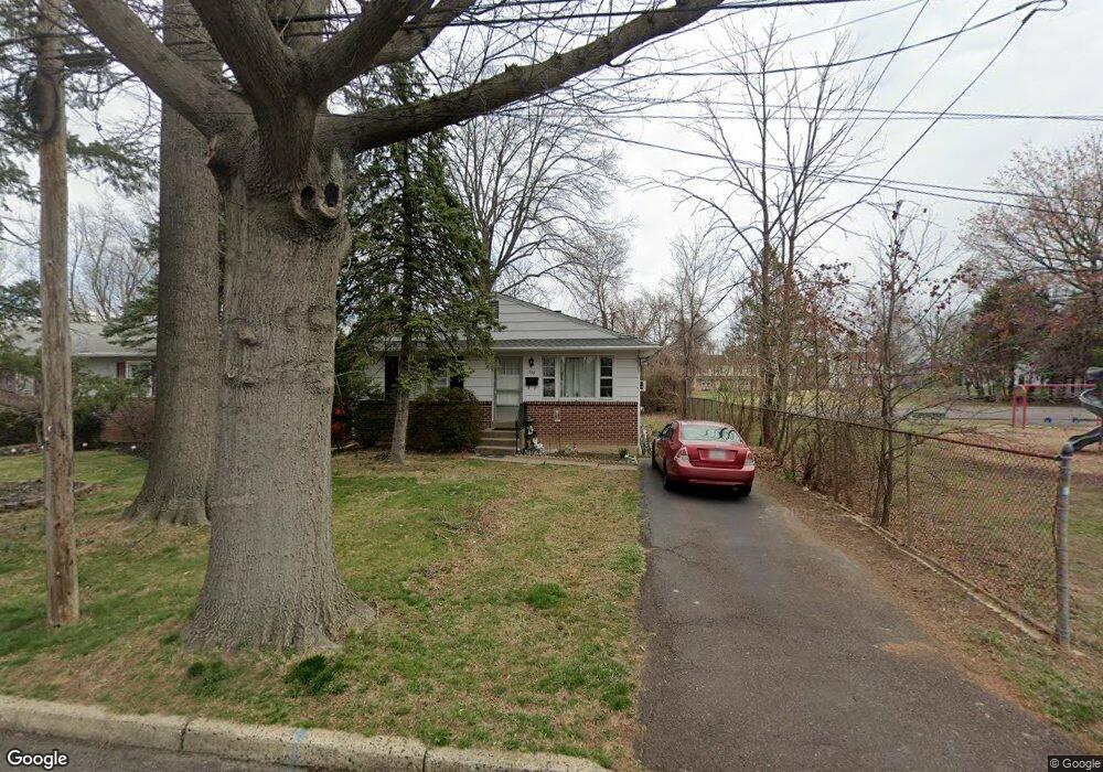
539 Maple St Warminster, PA 18974
Estimated Value: $369,000 - $440,000
3
Beds
1
Bath
1,200
Sq Ft
$334/Sq Ft
Est. Value
About This Home
This home is located at 539 Maple St, Warminster, PA 18974 and is currently estimated at $400,697, approximately $333 per square foot. 539 Maple St is a home located in Bucks County with nearby schools including McDonald Elementary School, Log College Middle School, and William Tennent High School.
Ownership History
Date
Name
Owned For
Owner Type
Purchase Details
Closed on
Aug 21, 2023
Sold by
Demetriou James G and Demetriou Michael A
Bought by
Demetriou George
Current Estimated Value
Purchase Details
Closed on
Jul 23, 1999
Sold by
Demetriou James
Bought by
Demetriou Michael A
Home Financials for this Owner
Home Financials are based on the most recent Mortgage that was taken out on this home.
Original Mortgage
$75,000
Interest Rate
7.65%
Purchase Details
Closed on
Sep 6, 1968
Bought by
Demetriou George N and Demetriou Jean
Create a Home Valuation Report for This Property
The Home Valuation Report is an in-depth analysis detailing your home's value as well as a comparison with similar homes in the area
Home Values in the Area
Average Home Value in this Area
Purchase History
| Date | Buyer | Sale Price | Title Company |
|---|---|---|---|
| Demetriou George | -- | Foundation Title | |
| Demetriou Michael A | -- | -- | |
| Demetriou George N | -- | -- |
Source: Public Records
Mortgage History
| Date | Status | Borrower | Loan Amount |
|---|---|---|---|
| Previous Owner | Demetriou Michael A | $75,000 |
Source: Public Records
Tax History
| Year | Tax Paid | Tax Assessment Tax Assessment Total Assessment is a certain percentage of the fair market value that is determined by local assessors to be the total taxable value of land and additions on the property. | Land | Improvement |
|---|---|---|---|---|
| 2025 | $3,923 | $18,000 | $2,920 | $15,080 |
| 2024 | $3,799 | $18,000 | $2,920 | $15,080 |
| 2023 | $3,682 | $18,000 | $2,920 | $15,080 |
| 2022 | $3,604 | $18,000 | $2,920 | $15,080 |
| 2021 | $3,520 | $18,000 | $2,920 | $15,080 |
| 2020 | $3,470 | $18,000 | $2,920 | $15,080 |
| 2019 | $3,286 | $18,000 | $2,920 | $15,080 |
| 2018 | $3,207 | $18,000 | $2,920 | $15,080 |
| 2017 | $3,113 | $18,000 | $2,920 | $15,080 |
| 2016 | $3,113 | $18,000 | $2,920 | $15,080 |
| 2015 | $3,109 | $18,000 | $2,920 | $15,080 |
| 2014 | $3,109 | $18,000 | $2,920 | $15,080 |
Source: Public Records
Map
Nearby Homes
- Lot 15 Kennedy Way
- 505 Orchard Ave
- 0 York Rd
- 746 Spruce Rd
- 641 Whittier Dr
- 632 Longfellow Ct
- 630 Whittier Dr
- 279 Gibson Ave
- 306 Grape St
- 485 4th Ave
- 737 Tennyson Dr
- 194 Gibson Ave
- 745 Tennyson Dr
- 473 3rd Ave
- 158 Wiltshire Ln
- 854 Phillips Rd
- 422 Brandywine Ct Unit YV422
- 909 Holden Ct
- L:26 Street Rd
- 942 Stein Ct
Your Personal Tour Guide
Ask me questions while you tour the home.