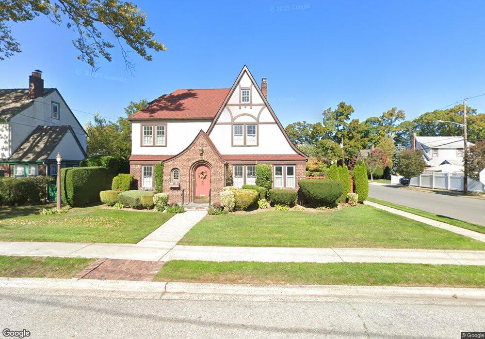
539 Stanton Ave North Baldwin, NY 11510
Estimated Value: $704,000 - $774,370
Studio
1
Bath
2,296
Sq Ft
$322/Sq Ft
Est. Value
About This Home
This home is located at 539 Stanton Ave, North Baldwin, NY 11510 and is currently estimated at $739,185, approximately $321 per square foot. 539 Stanton Ave is a home with nearby schools including Baldwin Senior High School.
Ownership History
Date
Name
Owned For
Owner Type
Purchase Details
Closed on
Sep 13, 2011
Sold by
Anderson Gary K and Anderson Lorraine M
Bought by
Costello Trini and Costello Family Trust
Current Estimated Value
Purchase Details
Closed on
Jan 28, 2000
Sold by
Watson Donald F and Havel Terry Anne
Bought by
Anderson Gary K and Anderson Lorraine M
Home Financials for this Owner
Home Financials are based on the most recent Mortgage that was taken out on this home.
Original Mortgage
$150,000
Interest Rate
7.62%
Mortgage Type
Purchase Money Mortgage
Create a Home Valuation Report for This Property
The Home Valuation Report is an in-depth analysis detailing your home's value as well as a comparison with similar homes in the area
Home Values in the Area
Average Home Value in this Area
Purchase History
| Date | Buyer | Sale Price | Title Company |
|---|---|---|---|
| Costello Trini | $440,000 | -- | |
| Anderson Gary K | $235,000 | First American Title Ins Co |
Source: Public Records
Mortgage History
| Date | Status | Borrower | Loan Amount |
|---|---|---|---|
| Previous Owner | Anderson Gary K | $150,000 |
Source: Public Records
Tax History
| Year | Tax Paid | Tax Assessment Tax Assessment Total Assessment is a certain percentage of the fair market value that is determined by local assessors to be the total taxable value of land and additions on the property. | Land | Improvement |
|---|---|---|---|---|
| 2025 | $13,347 | $468 | $139 | $329 |
| 2024 | $3,601 | $482 | $143 | $339 |
Source: Public Records
Map
Nearby Homes
- 560 Stowe Ave
- 1746 Rockville Dr
- 1624 Berkeley Ave
- 610 Emerson Ave
- 671 Stanton Ave
- 480 S Wood Rd
- 1854 Rockville Dr
- 1501 Kenneth Ave
- 1874 Rockville Dr
- 1600 Grand Ave Unit V1
- 1905 Bryant Place
- 1900 Carleton Place
- 1690 Grand Ave Unit A15
- 1690 Grand Ave Unit A16
- 477 De Mott Ave
- 2 Meadow Ln
- 661 Saint Lukes Place
- 578 Seaman Ave
- 810 Wallace Ave
- 1878 Lake Dr W
- 531 Stanton Ave
- 547 Stanton Ave
- 525 Stanton Ave
- 1640 Kenneth Ave
- 551 Stanton Ave
- 540 Stanton Ave
- 551 Stanton Ave
- 1643 Westervelt Ave
- 526 Stanton Ave
- 521 Stanton Ave
- 1643 Kenneth Ave
- 1636 Kenneth Ave
- 1669 Kenneth Ave
- 1637 Westervelt Ave
- 522 Stanton Ave
- 522 Stanton Ave
- 522 Stanton Ave
- 555 Stanton Ave
- 1637 Kenneth Ave
- 554 Stanton Ave
Your Personal Tour Guide
Ask me questions while you tour the home.