Estimated Value: $228,619 - $246,000
3
Beds
2
Baths
968
Sq Ft
$248/Sq Ft
Est. Value
About This Home
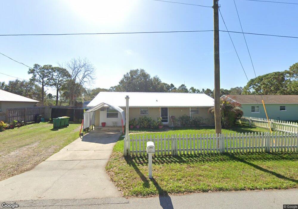
This home is located at 5397 Bridge Rd, Cocoa, FL 32927 and is currently estimated at $240,155, approximately $248 per square foot. 5397 Bridge Rd is a home located in Brevard County with nearby schools including Challenger 7 Elementary School, Space Coast Junior/Senior High School, and East Atlantic Prep of Brevard County.
Ownership History
Date
Name
Owned For
Owner Type
Purchase Details
Closed on
Jun 26, 2013
Sold by
Thi Justine Ronald and Thi Justine Ly
Bought by
Kroening John Lawrence and Kroening Donna Shannon
Current Estimated Value
Purchase Details
Closed on
Oct 22, 2011
Sold by
Cain Christopher
Bought by
Thi Justine Ronald and Thi Justine Ly
Create a Home Valuation Report for This Property
The Home Valuation Report is an in-depth analysis detailing your home's value as well as a comparison with similar homes in the area
Home Values in the Area
Average Home Value in this Area
Purchase History
| Date | Buyer | Sale Price | Title Company |
|---|---|---|---|
| Kroening John Lawrence | $48,500 | Fidelity National Title Of F | |
| Thi Justine Ronald | $42,647 | None Available |
Source: Public Records
Tax History
| Year | Tax Paid | Tax Assessment Tax Assessment Total Assessment is a certain percentage of the fair market value that is determined by local assessors to be the total taxable value of land and additions on the property. | Land | Improvement |
|---|---|---|---|---|
| 2025 | $851 | $56,430 | -- | -- |
| 2024 | $2,172 | $54,840 | -- | -- |
| 2023 | $2,172 | $53,250 | $0 | $0 |
| 2022 | $799 | $51,700 | $0 | $0 |
| 2021 | $800 | $50,200 | $0 | $0 |
| 2020 | $763 | $49,510 | $0 | $0 |
| 2019 | $702 | $48,400 | $0 | $0 |
| 2018 | $694 | $47,500 | $0 | $0 |
| 2017 | $686 | $46,530 | $0 | $0 |
| 2016 | $680 | $45,580 | $18,000 | $27,580 |
| 2015 | $677 | $45,270 | $15,000 | $30,270 |
| 2014 | $677 | $44,920 | $11,000 | $33,920 |
Source: Public Records
Map
Nearby Homes
- 5946 Deer Ln
- 5945 Coker Ave
- 6020 Cannon Ave
- 5950 Ackard Ave
- 5221 Carrick Rd
- 5215 Holden Rd
- 5720 Flint Rd
- 5220 Holden Rd
- 5601 Banos Ave
- 6094 Cardiff Ave
- 000 Port Saint John Pkwy
- No Access Port Saint John Pkwy
- 6438 Hudson Rd
- 5914 Stillwater Ave
- 5680 Banos Ave
- 5812 Homestead Ave
- 6481 La Brea Ave
- 4905 Bridge Rd
- 4975 Fay Blvd
- 6450 Ember Ave
Your Personal Tour Guide
Ask me questions while you tour the home.