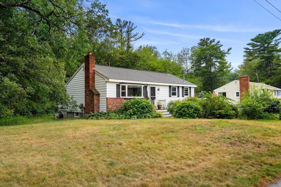


54 Delwood Rd Tewksbury, MA 01876
Estimated payment $3,631/month
Highlights
- Above Ground Pool
- Wooded Lot
- Wood Flooring
- Deck
- Ranch Style House
- 2 Fireplaces
About This Home
SOLD AS IS! Charming 3-bedroom home on 1.19 Acres with above -ground pool & detached shed. Welcome to this 3 bedroom, 1 bathroom home nestled on 1.19 private acres in the peaceful countryside of a range. With a cozy layout and a functional living space, this home offers comfort and versatility both inside and out.The spacious living area flows into bright kitchen and ample cabinetry and room for dining. Three comfortable size bedrooms and a full bath makes this a perfect starter home.downsizing option, or peaceful retreat. Step outside to enjoy the expansive yard, ideal for gardening, outdoor play, or entertain. Cool off in the summer with th above-ground pool, and take advantage of this detached shed for storage or hobbies.With room to grow and space to breath, this property offers the best of rural living with out sacrificing convenience.Don't miss this opportunity to own a slice of tranquility in Range!

Home Details
Home Type
- Single Family
Est. Annual Taxes
- $9,999
Year Built
- Built in 1966
Lot Details
- Street terminates at a dead end
- Fenced Yard
- Wooded Lot
Home Design
- Ranch Style House
- Frame Construction
- Shingle Roof
- Concrete Perimeter Foundation
Interior Spaces
- 1,008 Sq Ft Home
- 2 Fireplaces
- Storm Windows
- Washer and Gas Dryer Hookup
- Unfinished Basement
Kitchen
- Range
- Dishwasher
Flooring
- Wood
- Carpet
Bedrooms and Bathrooms
- 3 Bedrooms
- 1 Full Bathroom
Parking
- Detached Garage
- Off-Street Parking
Outdoor Features
- Above Ground Pool
- Deck
- Enclosed Patio or Porch
- Outdoor Storage
Utilities
- Cooling System Mounted In Outer Wall Opening
- Floor Furnace
- Baseboard Heating
- 100 Amp Service
- Water Heater
- Private Sewer
Listing and Financial Details
- Assessor Parcel Number 798296
Community Details
Overview
- No Home Owners Association
Recreation
- Community Pool
Map
Home Values in the Area
Average Home Value in this Area
Tax History
| Year | Tax Paid | Tax Assessment Tax Assessment Total Assessment is a certain percentage of the fair market value that is determined by local assessors to be the total taxable value of land and additions on the property. | Land | Improvement |
|---|---|---|---|---|
| 2025 | $6,202 | $469,100 | $245,500 | $223,600 |
| 2024 | $5,932 | $443,000 | $233,600 | $209,400 |
| 2023 | $5,843 | $414,400 | $212,700 | $201,700 |
| 2022 | $5,580 | $367,100 | $184,800 | $182,300 |
| 2021 | $5,263 | $334,800 | $168,300 | $166,500 |
| 2020 | $5,146 | $322,200 | $160,400 | $161,800 |
| 2019 | $4,833 | $305,100 | $152,600 | $152,500 |
| 2018 | $4,365 | $270,600 | $152,600 | $118,000 |
| 2017 | $4,135 | $253,500 | $152,600 | $100,900 |
| 2016 | $3,999 | $244,600 | $152,600 | $92,000 |
| 2015 | $3,786 | $231,300 | $148,200 | $83,100 |
| 2014 | $3,517 | $218,300 | $148,200 | $70,100 |
Property History
| Date | Event | Price | Change | Sq Ft Price |
|---|---|---|---|---|
| 08/11/2025 08/11/25 | Pending | -- | -- | -- |
| 08/04/2025 08/04/25 | For Sale | $529,900 | -- | $526 / Sq Ft |
Purchase History
| Date | Type | Sale Price | Title Company |
|---|---|---|---|
| Quit Claim Deed | -- | -- | |
| Land Court Massachusetts | $245,000 | -- | |
| Land Court Massachusetts | $189,000 | -- |
Mortgage History
| Date | Status | Loan Amount | Loan Type |
|---|---|---|---|
| Open | $337,810 | FHA | |
| Previous Owner | $254,309 | Stand Alone Refi Refinance Of Original Loan | |
| Previous Owner | $280,000 | No Value Available | |
| Previous Owner | $234,000 | No Value Available | |
| Previous Owner | $232,750 | Purchase Money Mortgage | |
| Previous Owner | $186,000 | No Value Available | |
| Previous Owner | $179,550 | Purchase Money Mortgage |
Source: MLS Property Information Network (MLS PIN)
MLS Number: 73413128
APN: TEWK-000106-000000-000036
Disclaimer: Certain information contained herein is derived from information provided by parties other than Homes.com. All information provided is deemed reliable, but is not guaranteed to be accurate and should be independently verified.
![]() The property listing data and information, or the Images, set forth herein were provided to MLS Property Information Network, Inc. from third party sources, including sellers, lessors and public records, and were compiled by MLS Property Information Network, Inc. The property listing data and information, and the Images, are for the personal, non-commercial use of consumers having a good faith interest in purchasing or leasing listed properties of the type displayed to them and may not be used for any purpose other than to identify prospective properties which such consumers may have a good faith interest in purchasing or leasing. MLS Property Information Network, Inc. and its subscribers disclaim any and all representations and warranties as to the accuracy of the property listing data and information, or as to the accuracy of any of the Images, set forth herein.
The property listing data and information, or the Images, set forth herein were provided to MLS Property Information Network, Inc. from third party sources, including sellers, lessors and public records, and were compiled by MLS Property Information Network, Inc. The property listing data and information, and the Images, are for the personal, non-commercial use of consumers having a good faith interest in purchasing or leasing listed properties of the type displayed to them and may not be used for any purpose other than to identify prospective properties which such consumers may have a good faith interest in purchasing or leasing. MLS Property Information Network, Inc. and its subscribers disclaim any and all representations and warranties as to the accuracy of the property listing data and information, or as to the accuracy of any of the Images, set forth herein.