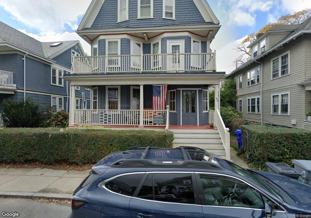
54 Dunster Rd Unit 1 Jamaica Plain, MA 02130
Jamaica Plain NeighborhoodEstimated Value: $750,000 - $837,000
3
Beds
1
Bath
1,375
Sq Ft
$562/Sq Ft
Est. Value
About This Home
This home is located at 54 Dunster Rd Unit 1, Jamaica Plain, MA 02130 and is currently estimated at $773,029, approximately $562 per square foot. 54 Dunster Rd Unit 1 is a home located in Suffolk County with nearby schools including The Croft School - Jamaica Plain and Meridian Academy.
Ownership History
Date
Name
Owned For
Owner Type
Purchase Details
Closed on
May 28, 2015
Sold by
Loring Ralph H and Bastanzuri Blanca I
Bought by
Ralph H Loring Ret
Current Estimated Value
Purchase Details
Closed on
Apr 30, 1987
Sold by
Mcgrath Neal F
Bought by
Loring Ralph H
Home Financials for this Owner
Home Financials are based on the most recent Mortgage that was taken out on this home.
Original Mortgage
$126,400
Interest Rate
8.99%
Mortgage Type
Purchase Money Mortgage
Create a Home Valuation Report for This Property
The Home Valuation Report is an in-depth analysis detailing your home's value as well as a comparison with similar homes in the area
Home Values in the Area
Average Home Value in this Area
Purchase History
| Date | Buyer | Sale Price | Title Company |
|---|---|---|---|
| Ralph H Loring Ret | -- | -- | |
| Loring Ralph H | $158,000 | -- |
Source: Public Records
Mortgage History
| Date | Status | Borrower | Loan Amount |
|---|---|---|---|
| Previous Owner | Loring Ralph H | $126,400 |
Source: Public Records
Tax History Compared to Growth
Tax History
| Year | Tax Paid | Tax Assessment Tax Assessment Total Assessment is a certain percentage of the fair market value that is determined by local assessors to be the total taxable value of land and additions on the property. | Land | Improvement |
|---|---|---|---|---|
| 2025 | $7,522 | $649,600 | $0 | $649,600 |
| 2024 | $6,216 | $570,300 | $0 | $570,300 |
| 2023 | $5,829 | $542,700 | $0 | $542,700 |
| 2022 | $5,572 | $512,100 | $0 | $512,100 |
| 2021 | $5,357 | $502,100 | $0 | $502,100 |
| 2020 | $4,858 | $460,000 | $0 | $460,000 |
| 2019 | $4,489 | $425,900 | $0 | $425,900 |
| 2018 | $4,376 | $417,600 | $0 | $417,600 |
| 2017 | $4,253 | $401,600 | $0 | $401,600 |
| 2016 | $4,168 | $378,900 | $0 | $378,900 |
| 2015 | $4,029 | $332,700 | $0 | $332,700 |
| 2014 | -- | $305,300 | $0 | $305,300 |
Source: Public Records
Map
Nearby Homes
- 54 Arborway
- 2 Brewer St
- 29 Goldsmith St Unit 1
- 27-29 Ballard St
- 55 South St
- 55 South St Unit 3
- 18 Atwood Square Unit 3
- 15 Harris Ave
- 41 Jamaica St
- 36 Alveston St
- 584 Centre St
- 1000 Centre St Unit 4
- 10 Jamaicaway Ct Unit 25
- 10 Jamaicaway Ct Unit 24
- 93 Sedgwick St
- 96 Jamaica St
- 66 Seaverns Ave Unit 68B
- 76 Elm St Unit G05
- 16 Mcbride St Unit 1
- 16 Mcbride St
- 54 Dunster Rd Unit 2
- 50 Dunster Rd Unit 2
- 50 Dunster Rd Unit 1
- 58 Dunster Rd
- 58 Dunster Rd
- 58 Dunster Rd Unit 2
- 49 Aldworth St
- 53 Aldworth St
- 53 Aldworth St Unit 2
- 46 Dunster Rd Unit 2
- 46 Dunster Rd Unit 1
- 62 Dunster Rd Unit 2
- 62 Dunster Rd Unit 1
- 62 Dunster Rd
- 53 Dunster Rd Unit 2
- 53 Dunster Rd Unit 1
- 45 Aldworth St
- 55 Dunster Rd
- 55 Dunster Rd Unit 1
- 61 Aldworth St