S
Seller's Agent in 2025
Stevedoug.com Team
Laer Realty
(617) 212-9598
2 in this area
68 Total Sales
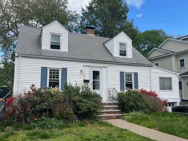
Lovely 3 bedroom cape with a generous deck and large sunroom in top neighborhood known for its convenience. Walking distance to the Mitchell Elementary School, Middle School and High School. Near Perry Park and the Hersey Commuter Rail Station and town center. Hardwood floors. Great opportunity to get into Needham.
| Date | Type | Sale Price | Title Company |
|---|---|---|---|
| Quit Claim Deed | $923,850 | -- | |
| Land Court Massachusetts | $340,000 | -- | |
| Leasehold Conv With Agreement Of Sale Fee Purchase Hawaii | $235,000 | -- | |
| Leasehold Conv With Agreement Of Sale Fee Purchase Hawaii | $235,000 | -- | |
| Leasehold Conv With Agreement Of Sale Fee Purchase Hawaii | $235,000 | -- |
| Date | Status | Loan Amount | Loan Type |
|---|---|---|---|
| Open | $1,692,888 | Purchase Money Mortgage | |
| Previous Owner | $212,000 | No Value Available | |
| Previous Owner | $188,000 | No Value Available | |
| Previous Owner | $188,000 | Purchase Money Mortgage |
| Date | Event | Price | List to Sale | Price per Sq Ft |
|---|---|---|---|---|
| 09/10/2025 09/10/25 | Sold | $923,850 | -6.6% | $954 / Sq Ft |
| 07/16/2025 07/16/25 | Pending | -- | -- | -- |
| 07/15/2025 07/15/25 | For Sale | $989,000 | 0.0% | $1,022 / Sq Ft |
| 06/18/2025 06/18/25 | Pending | -- | -- | -- |
| 05/27/2025 05/27/25 | For Sale | $989,000 | -- | $1,022 / Sq Ft |
| Year | Tax Paid | Tax Assessment Tax Assessment Total Assessment is a certain percentage of the fair market value that is determined by local assessors to be the total taxable value of land and additions on the property. | Land | Improvement |
|---|---|---|---|---|
| 2025 | $9,854 | $929,600 | $767,600 | $162,000 |
| 2024 | $9,832 | $785,300 | $565,000 | $220,300 |
| 2023 | $9,995 | $766,500 | $565,000 | $201,500 |
| 2022 | $9,302 | $695,700 | $500,100 | $195,600 |
| 2021 | $9,065 | $695,700 | $500,100 | $195,600 |
| 2020 | $8,714 | $697,700 | $502,200 | $195,500 |
| 2019 | $8,052 | $649,900 | $456,600 | $193,300 |
| 2018 | $7,721 | $649,900 | $456,600 | $193,300 |
| 2017 | $7,434 | $625,200 | $456,600 | $168,600 |
| 2016 | $7,215 | $625,200 | $456,600 | $168,600 |
| 2015 | $7,059 | $625,200 | $456,600 | $168,600 |
| 2014 | $6,346 | $545,200 | $380,500 | $164,700 |
S
Seller's Agent in 2025
Stevedoug.com Team
Laer Realty
(617) 212-9598
2 in this area
68 Total Sales
M
Seller Co-Listing Agent in 2025
Maureen Dwyer
Laer Realty
1 in this area
3 Total Sales

Buyer's Agent in 2025
Maura Cutting
(781) 844-6078
52 in this area
81 Total Sales
Source: MLS Property Information Network (MLS PIN)
MLS Number: 73380509
APN: NEED-000023-000064
Disclaimer: Certain information contained herein is derived from information provided by parties other than Homes.com. All information provided is deemed reliable, but is not guaranteed to be accurate and should be independently verified.
![]() The property listing data and information, or the Images, set forth herein were provided to MLS Property Information Network, Inc. from third party sources, including sellers, lessors and public records, and were compiled by MLS Property Information Network, Inc. The property listing data and information, and the Images, are for the personal, non-commercial use of consumers having a good faith interest in purchasing or leasing listed properties of the type displayed to them and may not be used for any purpose other than to identify prospective properties which such consumers may have a good faith interest in purchasing or leasing. MLS Property Information Network, Inc. and its subscribers disclaim any and all representations and warranties as to the accuracy of the property listing data and information, or as to the accuracy of any of the Images, set forth herein.
The property listing data and information, or the Images, set forth herein were provided to MLS Property Information Network, Inc. from third party sources, including sellers, lessors and public records, and were compiled by MLS Property Information Network, Inc. The property listing data and information, and the Images, are for the personal, non-commercial use of consumers having a good faith interest in purchasing or leasing listed properties of the type displayed to them and may not be used for any purpose other than to identify prospective properties which such consumers may have a good faith interest in purchasing or leasing. MLS Property Information Network, Inc. and its subscribers disclaim any and all representations and warranties as to the accuracy of the property listing data and information, or as to the accuracy of any of the Images, set forth herein.
Ask me questions while you tour the home.