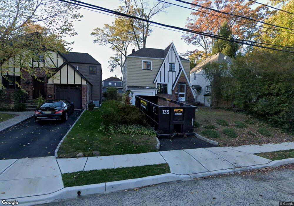
54 Marlboro Rd Clifton, NJ 07012
Allwood NeighborhoodEstimated Value: $527,000 - $647,000
--
Bed
--
Bath
1,152
Sq Ft
$499/Sq Ft
Est. Value
About This Home
This home is located at 54 Marlboro Rd, Clifton, NJ 07012 and is currently estimated at $574,379, approximately $498 per square foot. 54 Marlboro Rd is a home located in Passaic County with nearby schools including Clifton High School, St Andrew Elementary School, and St Clare Elementary School.
Ownership History
Date
Name
Owned For
Owner Type
Purchase Details
Closed on
Jul 27, 2021
Sold by
Freeswick William H and Freeswick Donna A
Bought by
Tomi Matthew and Pereira Aslin
Current Estimated Value
Home Financials for this Owner
Home Financials are based on the most recent Mortgage that was taken out on this home.
Original Mortgage
$408,500
Outstanding Balance
$372,007
Interest Rate
3%
Mortgage Type
New Conventional
Estimated Equity
$202,372
Purchase Details
Closed on
Sep 30, 2020
Sold by
Neuman Arlene and Estate Of Robert N Miller
Bought by
Freeswick William H and Freeswick Donna A
Create a Home Valuation Report for This Property
The Home Valuation Report is an in-depth analysis detailing your home's value as well as a comparison with similar homes in the area
Home Values in the Area
Average Home Value in this Area
Purchase History
| Date | Buyer | Sale Price | Title Company |
|---|---|---|---|
| Tomi Matthew | $454,000 | Acres Land Title Agency Inc | |
| Tomi Matthew | $454,000 | Acres Land Title | |
| Freeswick William H | $240,000 | Sunnyside Title |
Source: Public Records
Mortgage History
| Date | Status | Borrower | Loan Amount |
|---|---|---|---|
| Open | Tomi Matthew | $408,500 | |
| Closed | Tomi Matthew | $408,500 |
Source: Public Records
Tax History Compared to Growth
Tax History
| Year | Tax Paid | Tax Assessment Tax Assessment Total Assessment is a certain percentage of the fair market value that is determined by local assessors to be the total taxable value of land and additions on the property. | Land | Improvement |
|---|---|---|---|---|
| 2025 | $9,462 | $159,400 | $88,400 | $71,000 |
| 2024 | $9,236 | $159,400 | $88,400 | $71,000 |
| 2022 | $9,102 | $159,400 | $88,400 | $71,000 |
| 2021 | $8,278 | $151,200 | $88,400 | $62,800 |
| 2020 | $8,305 | $151,200 | $88,400 | $62,800 |
| 2019 | $8,246 | $151,200 | $88,400 | $62,800 |
| 2018 | $8,200 | $151,200 | $88,400 | $62,800 |
| 2017 | $8,110 | $151,200 | $88,400 | $62,800 |
| 2016 | $7,885 | $149,900 | $88,400 | $61,500 |
| 2015 | $7,808 | $149,900 | $88,400 | $61,500 |
| 2014 | $7,648 | $149,900 | $88,400 | $61,500 |
Source: Public Records
Map
Nearby Homes