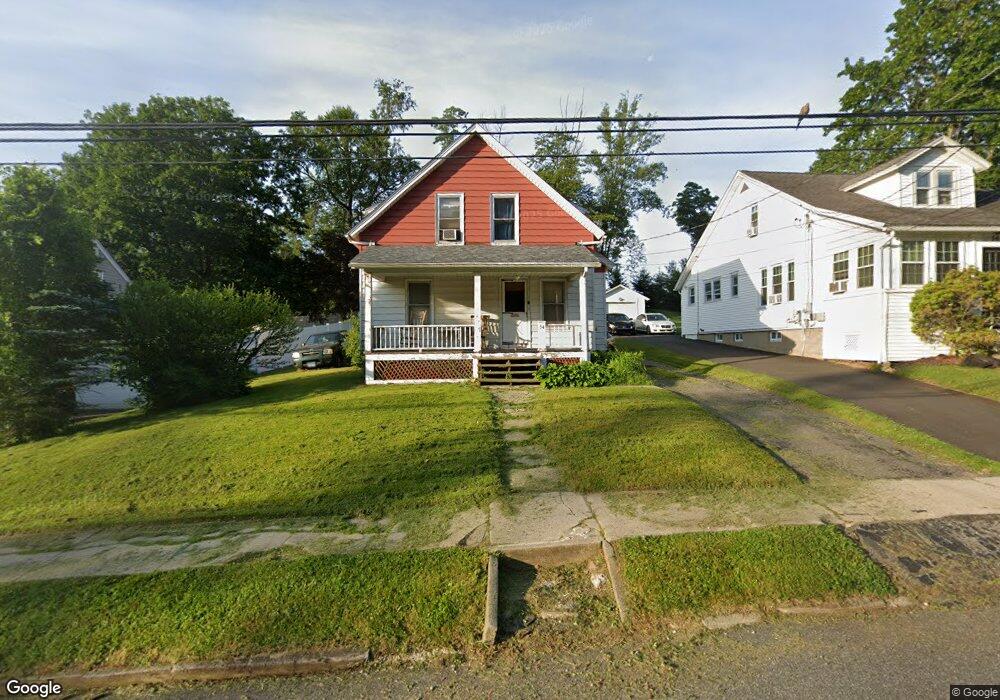
54 Pershing Ave Seymour, CT 06483
Estimated Value: $285,000 - $318,000
3
Beds
2
Baths
1,043
Sq Ft
$292/Sq Ft
Est. Value
About This Home
This home is located at 54 Pershing Ave, Seymour, CT 06483 and is currently estimated at $304,244, approximately $291 per square foot. 54 Pershing Ave is a home located in New Haven County with nearby schools including Seymour Middle School, Seymour High School, and Assumption School.
Ownership History
Date
Name
Owned For
Owner Type
Purchase Details
Closed on
Feb 5, 2007
Sold by
Est Lysak Charles H and Lysak David
Bought by
Mercado Mary A
Current Estimated Value
Home Financials for this Owner
Home Financials are based on the most recent Mortgage that was taken out on this home.
Original Mortgage
$144,000
Outstanding Balance
$86,250
Interest Rate
6.16%
Estimated Equity
$217,994
Create a Home Valuation Report for This Property
The Home Valuation Report is an in-depth analysis detailing your home's value as well as a comparison with similar homes in the area
Home Values in the Area
Average Home Value in this Area
Purchase History
| Date | Buyer | Sale Price | Title Company |
|---|---|---|---|
| Mercado Mary A | $180,000 | -- |
Source: Public Records
Mortgage History
| Date | Status | Borrower | Loan Amount |
|---|---|---|---|
| Open | Mercado Mary A | $144,000 | |
| Closed | Mercado Mary A | $36,000 |
Source: Public Records
Tax History
| Year | Tax Paid | Tax Assessment Tax Assessment Total Assessment is a certain percentage of the fair market value that is determined by local assessors to be the total taxable value of land and additions on the property. | Land | Improvement |
|---|---|---|---|---|
| 2025 | $4,341 | $156,590 | $44,240 | $112,350 |
| 2024 | $4,397 | $119,350 | $34,720 | $84,630 |
| 2023 | $4,294 | $119,350 | $34,720 | $84,630 |
| 2022 | $4,248 | $119,350 | $34,720 | $84,630 |
| 2021 | $4,143 | $119,350 | $34,720 | $84,630 |
| 2020 | $3,903 | $108,430 | $40,880 | $67,550 |
| 2019 | $3,903 | $108,430 | $40,880 | $67,550 |
| 2018 | $3,903 | $108,430 | $40,880 | $67,550 |
| 2017 | $3,903 | $108,430 | $40,880 | $67,550 |
| 2016 | $3,903 | $108,430 | $40,880 | $67,550 |
| 2015 | $3,823 | $110,530 | $42,980 | $67,550 |
| 2014 | $3,762 | $110,530 | $42,980 | $67,550 |
Source: Public Records
Map
Nearby Homes
- 32 George St
- 68 New St
- 17 Grand St
- 11 Oxford Rd
- 17-23 Meadow St
- 12 Susan St
- 26 Stoddard St
- 0 Hill East Rd Unit 24131331
- 93 Balance Rock Rd Unit 1
- 122 Derby Ave
- 53-55 Maple St
- 79 Balance Rock Rd Unit 8
- 312 Spruce Hill Dr
- 73 Micko Dr
- 48 Micko Dr
- 75 Balance Rock Rd Unit 20
- 3 Willow St
- 67 Micko Dr
- 71 Micko Dr
- 69 Micko Dr
- 56 Pershing Ave
- 52 Pershing Ave
- 50 Pershing Ave
- 58 Pershing Ave
- 48 Pershing Ave
- 51 Pershing Ave
- 57 Pershing Ave
- 38-44 George St
- 18 Rimmon St
- 46 Pershing Ave
- 61 Pershing Ave
- 47 Pershing Ave
- 36 George St
- 43 George St Unit 9
- 43 George St Unit 10
- 43 George St Unit 8
- 43 George St Unit 7
- 43 George St Unit 6
- 43 George St Unit 5
- 43 George St Unit 4
Your Personal Tour Guide
Ask me questions while you tour the home.