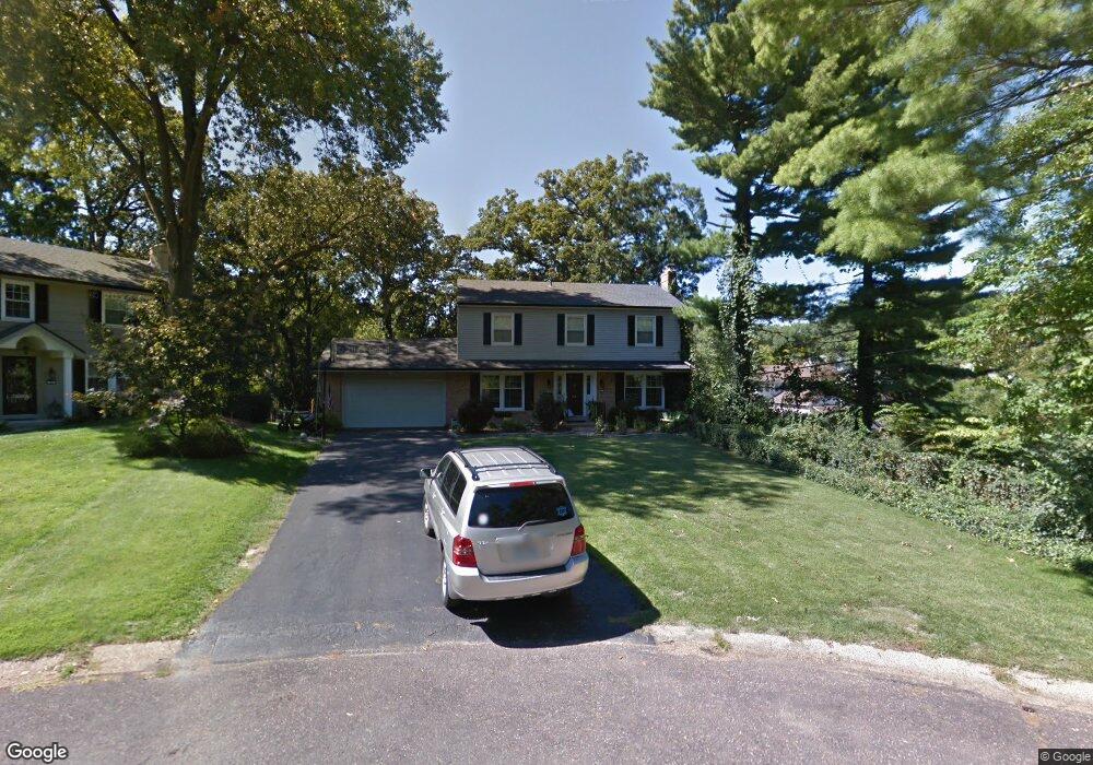
54 Wingfield Rd Saint Louis, MO 63122
Estimated Value: $517,000 - $705,000
4
Beds
3
Baths
2,274
Sq Ft
$276/Sq Ft
Est. Value
About This Home
This home is located at 54 Wingfield Rd, Saint Louis, MO 63122 and is currently estimated at $626,601, approximately $275 per square foot. 54 Wingfield Rd is a home located in St. Louis County with nearby schools including North Glendale Elementary School, Nipher Middle School, and Kirkwood Senior High School.
Ownership History
Date
Name
Owned For
Owner Type
Purchase Details
Closed on
Jul 22, 2025
Sold by
Darland Kurtis and Darland Mary Clare
Bought by
Kurtis Lee Darland And Mary Clare Darland Rev and Darland
Current Estimated Value
Purchase Details
Closed on
Apr 1, 2009
Sold by
Darland Kurtis and Darland Mary Clare
Bought by
Darland Kurtis L and Darland Mary Clare
Home Financials for this Owner
Home Financials are based on the most recent Mortgage that was taken out on this home.
Original Mortgage
$213,500
Interest Rate
5.24%
Mortgage Type
Stand Alone Refi Refinance Of Original Loan
Purchase Details
Closed on
Jan 6, 2005
Sold by
Koch Paul B and Koch Margaret Challen
Bought by
Darland Kurtis and Darland Mary Clare
Home Financials for this Owner
Home Financials are based on the most recent Mortgage that was taken out on this home.
Original Mortgage
$225,000
Interest Rate
5.8%
Mortgage Type
Purchase Money Mortgage
Create a Home Valuation Report for This Property
The Home Valuation Report is an in-depth analysis detailing your home's value as well as a comparison with similar homes in the area
Home Values in the Area
Average Home Value in this Area
Purchase History
| Date | Buyer | Sale Price | Title Company |
|---|---|---|---|
| Kurtis Lee Darland And Mary Clare Darland Rev | -- | None Listed On Document | |
| Darland Kurtis L | -- | Kts | |
| Darland Kurtis | $345,000 | -- |
Source: Public Records
Mortgage History
| Date | Status | Borrower | Loan Amount |
|---|---|---|---|
| Previous Owner | Darland Kurtis L | $213,500 | |
| Previous Owner | Darland Kurtis | $225,000 |
Source: Public Records
Tax History Compared to Growth
Tax History
| Year | Tax Paid | Tax Assessment Tax Assessment Total Assessment is a certain percentage of the fair market value that is determined by local assessors to be the total taxable value of land and additions on the property. | Land | Improvement |
|---|---|---|---|---|
| 2025 | $6,485 | $113,930 | $61,850 | $52,080 |
| 2024 | $6,485 | $99,320 | $44,160 | $55,160 |
| 2023 | $6,485 | $99,320 | $44,160 | $55,160 |
| 2022 | $6,159 | $89,210 | $46,970 | $42,240 |
| 2021 | $6,072 | $89,210 | $46,970 | $42,240 |
| 2020 | $6,063 | $85,200 | $40,260 | $44,940 |
| 2019 | $5,911 | $85,200 | $40,260 | $44,940 |
| 2018 | $5,890 | $75,980 | $35,340 | $40,640 |
| 2017 | $5,934 | $75,980 | $35,340 | $40,640 |
| 2016 | $5,399 | $69,580 | $31,810 | $37,770 |
| 2015 | $5,166 | $69,580 | $31,810 | $37,770 |
| 2014 | $5,247 | $69,200 | $23,120 | $46,080 |
Source: Public Records
Map
Nearby Homes
- 1025 Glenmoor Ln
- 939 Victoria Place
- 1095 N Sappington Rd
- 65 Ridge Line Dr
- 1306 Glendale Gardens Dr Unit B
- 1306 Glendale Gardens Dr Unit C
- 1509 Andrew Dr
- 827 Yosemite Dr
- 830 Victoria Place
- 931 Brownell Ave
- 28 Berry Road Park
- 987 Dwyer Ave
- 858 Chelsea Ave
- 826 Chelsea Ave
- 946 Dwyer Ave
- 1629 Andrew Dr
- 1105 Timberlane Dr
- 641 Brookhaven Ct
- 1 Dickson Ct
- 754 Brownell Ave
- 52 Wingfield Rd
- 1210 Carol Ann Place
- 51 Frederick Ln
- 1050 Nancy Carol Ln
- 1220 Carol Ann Place
- 50 Wingfield Rd
- 1230 Carol Ann Place
- 46 Wingfield Rd
- 46 Frederick Ln
- 55 Frederick Ln
- 1044 Nancy Carol Ln
- 1053 Glenbrook Ave
- 1240 Carol Ann Place
- 41 Berry Wood Dr
- 1045 Glenbrook Ave
- 1219 Carol Ann Place
- 39 Berry Wood Dr
- 1038 Nancy Carol Ln
- 44 Frederick Ln
- 1250 Carol Ann Place