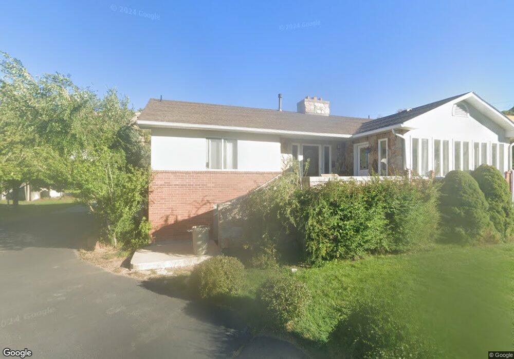
540 N 1420 E Logan, UT 84321
Wilson NeighborhoodEstimated Value: $512,000 - $567,615
Studio
--
Bath
1,550
Sq Ft
$345/Sq Ft
Est. Value
About This Home
This home is located at 540 N 1420 E, Logan, UT 84321 and is currently estimated at $534,404, approximately $344 per square foot. 540 N 1420 E is a home with nearby schools including Wilson School, Mount Logan Middle School, and Logan High School.
Ownership History
Date
Name
Owned For
Owner Type
Purchase Details
Closed on
Aug 20, 2021
Sold by
Lehenbaner Ruth Benson and Lehenbauer Marital Trust
Bought by
Guanuna Elizabeth L
Current Estimated Value
Home Financials for this Owner
Home Financials are based on the most recent Mortgage that was taken out on this home.
Original Mortgage
$425,000
Outstanding Balance
$384,181
Interest Rate
2.8%
Mortgage Type
Commercial
Estimated Equity
$150,223
Purchase Details
Closed on
Jun 14, 2017
Sold by
Lahenbauer Ruth Benson
Bought by
Lahenbauer Ruth Benson and The Lahenbauer Family Trust
Purchase Details
Closed on
Feb 28, 2013
Sold by
Benson Jan and Benson Sheree Hilton
Bought by
Benson Jan and Jan Benson Inter Vivos Trust
Purchase Details
Closed on
Nov 22, 2011
Sold by
Lehenbauer Ruth Benson
Bought by
Benson Jan and Benson Sheree Hilton
Create a Home Valuation Report for This Property
The Home Valuation Report is an in-depth analysis detailing your home's value as well as a comparison with similar homes in the area
Home Values in the Area
Average Home Value in this Area
Purchase History
| Date | Buyer | Sale Price | Title Company |
|---|---|---|---|
| Guanuna Elizabeth L | -- | Northern Title Company | |
| Lehenbauer Ruth Benson | -- | Northern Title Company | |
| Lahenbauer Ruth Benson | -- | Northern Title Company | |
| Benson Jan | -- | None Available | |
| Benson Jan | -- | Northern Title Company |
Source: Public Records
Mortgage History
| Date | Status | Borrower | Loan Amount |
|---|---|---|---|
| Open | Guanuna Elizabeth L | $425,000 |
Source: Public Records
Tax History
| Year | Tax Paid | Tax Assessment Tax Assessment Total Assessment is a certain percentage of the fair market value that is determined by local assessors to be the total taxable value of land and additions on the property. | Land | Improvement |
|---|---|---|---|---|
| 2025 | $2,315 | $299,410 | $0 | $0 |
| 2024 | $2,390 | $299,410 | $0 | $0 |
| 2023 | $2,491 | $297,475 | $0 | $0 |
| 2022 | $223 | $248,690 | $0 | $0 |
| 2021 | $2,202 | $379,240 | $87,550 | $291,690 |
| 2020 | $2,013 | $312,000 | $87,550 | $224,450 |
| 2019 | $2,188 | $312,000 | $87,550 | $224,450 |
| 2018 | $2,169 | $293,690 | $87,550 | $206,140 |
| 2017 | $1,957 | $140,115 | $0 | $0 |
| 2016 | $2,029 | $140,500 | $0 | $0 |
| 2015 | $1,671 | $115,260 | $0 | $0 |
| 2014 | $1,510 | $115,260 | $0 | $0 |
| 2013 | -- | $115,260 | $0 | $0 |
Source: Public Records
Map
Nearby Homes
- 1535 Sumac Dr
- 1374 Maple Dr
- 825 N 1400 E
- 866 Hillcrest Ave
- 1387 E 260 N
- 1374 E 260 N
- 1045 Fox Farm Rd
- 1133 N 1520 E
- 1034 Thrushwood Dr
- 147 Winding Way Unit 50
- 1357 E 1220 N
- 128 S 1170 E
- 1512 E 1260 N
- 2758 N Canyon Cove Dr
- 2738 N Canyon Cove Dr
- 1147 Eastridge Dr
- 1647 E Quail Canyon Dr
- 74 Canterbury Cir
- 1782 E 1250 N
- 631 E 600 N
Your Personal Tour Guide
Ask me questions while you tour the home.