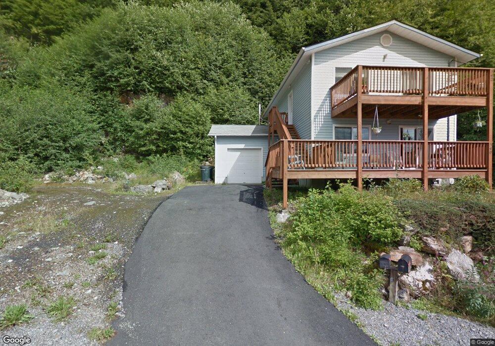
540 N Yorktown Dr Unit 542 Ketchikan, AK 99901
Estimated Value: $386,509 - $458,000
2
Beds
1
Bath
1,008
Sq Ft
$416/Sq Ft
Est. Value
About This Home
This home is located at 540 N Yorktown Dr Unit 542, Ketchikan, AK 99901 and is currently estimated at $419,170, approximately $415 per square foot. 540 N Yorktown Dr Unit 542 is a home located in Ketchikan Gateway Borough with nearby schools including Ketchikan High School, Tongass School of Arts & Sciences Charter School, and Ketchikan Charter School.
Ownership History
Date
Name
Owned For
Owner Type
Purchase Details
Closed on
Dec 4, 2018
Sold by
Roth Kelley and Roth Pamela S
Bought by
Seibel Kyle C and Hofmann Shawna R
Current Estimated Value
Home Financials for this Owner
Home Financials are based on the most recent Mortgage that was taken out on this home.
Original Mortgage
$256,000
Outstanding Balance
$225,541
Interest Rate
4.8%
Mortgage Type
New Conventional
Estimated Equity
$193,629
Create a Home Valuation Report for This Property
The Home Valuation Report is an in-depth analysis detailing your home's value as well as a comparison with similar homes in the area
Home Values in the Area
Average Home Value in this Area
Purchase History
| Date | Buyer | Sale Price | Title Company |
|---|---|---|---|
| Seibel Kyle C | -- | None Available |
Source: Public Records
Mortgage History
| Date | Status | Borrower | Loan Amount |
|---|---|---|---|
| Open | Seibel Kyle C | $256,000 |
Source: Public Records
Tax History Compared to Growth
Tax History
| Year | Tax Paid | Tax Assessment Tax Assessment Total Assessment is a certain percentage of the fair market value that is determined by local assessors to be the total taxable value of land and additions on the property. | Land | Improvement |
|---|---|---|---|---|
| 2025 | $3,665 | $320,100 | $42,500 | $277,600 |
| 2024 | $3,499 | $308,300 | $40,700 | $267,600 |
| 2023 | $3,356 | $284,400 | $33,700 | $250,700 |
| 2022 | $3,223 | $273,100 | $33,700 | $239,400 |
| 2021 | $3,114 | $263,900 | $33,700 | $230,200 |
| 2020 | $3,045 | $262,500 | $33,700 | $228,800 |
| 2019 | $2,984 | $257,200 | $33,700 | $223,500 |
| 2018 | $2,932 | $252,800 | $33,700 | $219,100 |
| 2017 | $2,814 | $240,500 | $0 | $0 |
| 2016 | $2,656 | $227,000 | $0 | $0 |
| 2015 | -- | $221,600 | $0 | $0 |
| 2014 | -- | $221,600 | $0 | $0 |
Source: Public Records
Map
Nearby Homes
- 464 Schoenbar Rd
- 0 N Legal Address Only Unit Long Arm - Moser Bay
- 0 N Legal Address Only Unit Lot 13, Stedman Stre
- 0 N Legal Address Only Unit 5100 Block of North
- 0 N Legal Address Only Unit L7-11B N Yorktown Dr
- Lots 7-11B N Yorktown Dr
- 1350 Woodside Dr
- 800 BLK Miller Ridge Rd
- 835 Harris St
- 772 Amundsen Way
- 930 Freeman St
- 930 & 936 Freeman St
- 647 Park Ave
- 764-766 Forest Ave
- 1227 Black Bear Rd Unit 1229
- 1 Creek St
- 320 Bawden St Unit 613-614
- 320 Bawden St
- 320 Bawden St Unit 718
- 320 Bawden St Unit 509
- L1-2 B4 N Yorktown Dr
- 535 N Yorktown Dr
- 537 N Yorktown Dr Unit 539
- 533 N Yorktown Dr Unit 535
- 533-535 N Yorktown Dr
- 515 N Yorktown Dr Unit 517
- 1300 N Yorktown Dr
- 470-472 N Yorktown Dr
- 536 Schoenbar Rd
- 516 Schoenbar Rd
- 540 Schoenbar Rd Unit 542
- 596 Schoenbar Rd
- 606 Schoenbar Rd
- 616 Schoenbar Rd
- 626 Schoenbar Rd
- 636 Schoenbar Rd
- 454 Schoenbar Rd
- 646 Schoenbar Rd
- 0 N Legal Address Only Unit Lot 1, Block 1 Timbe
- 0 N Legal Address Only Unit L 11, B 2, ASLS85-86