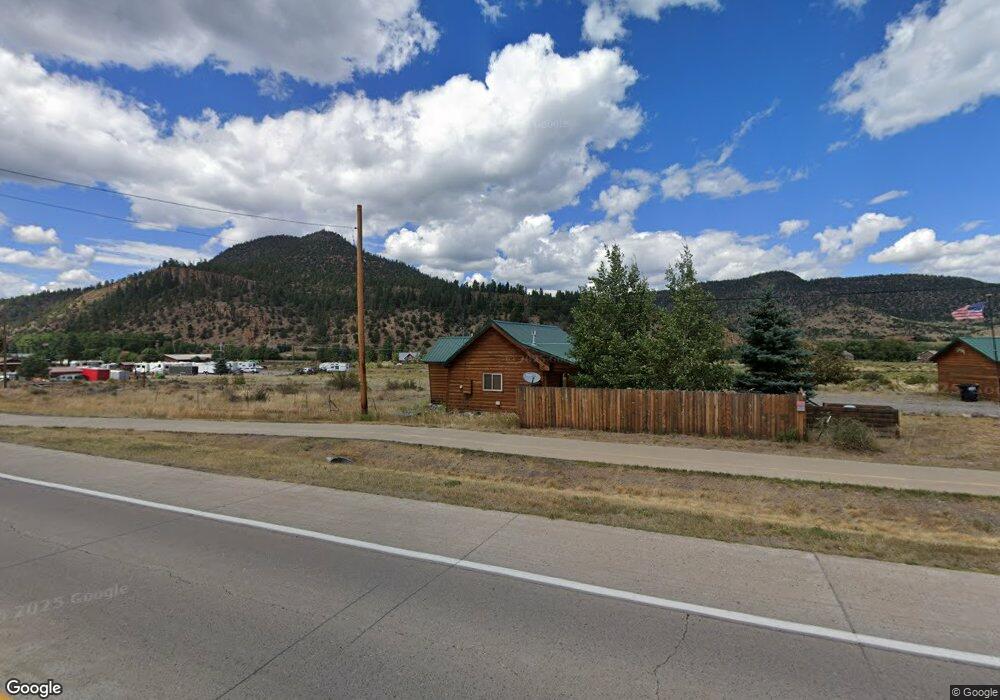
540 State Highway 149 South Fork, CO 81154
Estimated Value: $189,000 - $283,000
2
Beds
1
Bath
660
Sq Ft
$371/Sq Ft
Est. Value
About This Home
This home is located at 540 State Highway 149, South Fork, CO 81154 and is currently estimated at $244,960, approximately $371 per square foot. 540 State Highway 149 is a home located in Rio Grande County with nearby schools including Del Norte K-8 School and Del Norte High School.
Ownership History
Date
Name
Owned For
Owner Type
Purchase Details
Closed on
Dec 16, 2014
Sold by
B & R Llc
Bought by
Dame Phillip A and Johnson Dame Catherine A
Current Estimated Value
Purchase Details
Closed on
Jun 20, 2014
Sold by
Rominger Kent and Rominger Brown Lynne
Bought by
Rominger Kent and Rominger Brown Lynne
Purchase Details
Closed on
Dec 27, 2013
Sold by
Rominger Kent and Rominger Brown Lynne
Bought by
B & R Llc
Purchase Details
Closed on
Apr 27, 2010
Sold by
Romingers Hardware Inc
Bought by
Rominger Ralph Vernon
Purchase Details
Closed on
Dec 22, 2009
Sold by
H & V Hardware Co
Bought by
Rominger Ralph Vernon
Create a Home Valuation Report for This Property
The Home Valuation Report is an in-depth analysis detailing your home's value as well as a comparison with similar homes in the area
Home Values in the Area
Average Home Value in this Area
Purchase History
| Date | Buyer | Sale Price | Title Company |
|---|---|---|---|
| Dame Phillip A | -- | None Available | |
| Dame Phillip H | $62,500 | None Available | |
| Rominger Kent | -- | None Available | |
| B & R Llc | -- | None Available | |
| Rominger Ralph Vernon | -- | None Available | |
| Rominger Ralph Vernon | -- | None Available |
Source: Public Records
Tax History Compared to Growth
Tax History
| Year | Tax Paid | Tax Assessment Tax Assessment Total Assessment is a certain percentage of the fair market value that is determined by local assessors to be the total taxable value of land and additions on the property. | Land | Improvement |
|---|---|---|---|---|
| 2024 | $692 | $10,667 | $1,151 | $9,516 |
| 2023 | $692 | $10,667 | $1,151 | $9,516 |
| 2022 | $681 | $10,467 | $1,606 | $8,861 |
| 2021 | $689 | $10,769 | $1,653 | $9,116 |
| 2020 | $574 | $8,939 | $1,343 | $7,596 |
| 2019 | $575 | $8,939 | $1,343 | $7,596 |
| 2018 | $550 | $8,506 | $0 | $0 |
| 2017 | $555 | $8,506 | $0 | $0 |
| 2016 | $224 | $4,432 | $0 | $0 |
| 2015 | $234 | $4,432 | $0 | $0 |
| 2014 | $234 | $4,618 | $0 | $0 |
| 2013 | $242 | $4,618 | $0 | $0 |
Source: Public Records
Map
Nearby Homes
- 152 Conifer Dr
- 59 Willow St
- 222 Bristle Cone Dr
- 38 Cedar Dr
- 58 Cedar Dr
- 22 Cedar Dr
- 116 Big River Way
- 132 Big River Way
- 328 Fir Dr
- 7 Cottonwood Dr
- 0 Aspen Dr
- 0253 Aspen Cir
- 464 Colorado 149
- 59 Spruce Dr W
- Undisclosed Beaver Creek Rd
- 0 U S 160 Unit 827893
- TBD Little Bear Circle Lot 41
- 0 Ellingwood Dr Unit 814728
- TBD Colorado 149
- 56 E Frontage Rd
- W Lodge Dr
- 10 Spruce Dr W
- 13 Lodge Dr E
- 13 Lodge Dr
- 0 Lodge Dr E Unit 754541
- 0 Lodge Dr E Unit 686173
- 0 Lodge Dr E Unit 672553
- 0 Lodge Dr E Unit 695466
- 0 Lodge Unit 717174
- 0013 Lodge Dr W
- 00225 State Highway 149
- S Spruce
- 30 Spruce Dr W
- 20 Lodge Dr E
- 0020 W Lodge Dr
- 0 Spruce Dr W Unit 752280
- 0 Spruce Dr W Unit 662594
- 0 Spruce Dr W Unit 701562
- 0 Spruce Dr W Unit 703454
- 0 Spruce Dr W Unit 714611