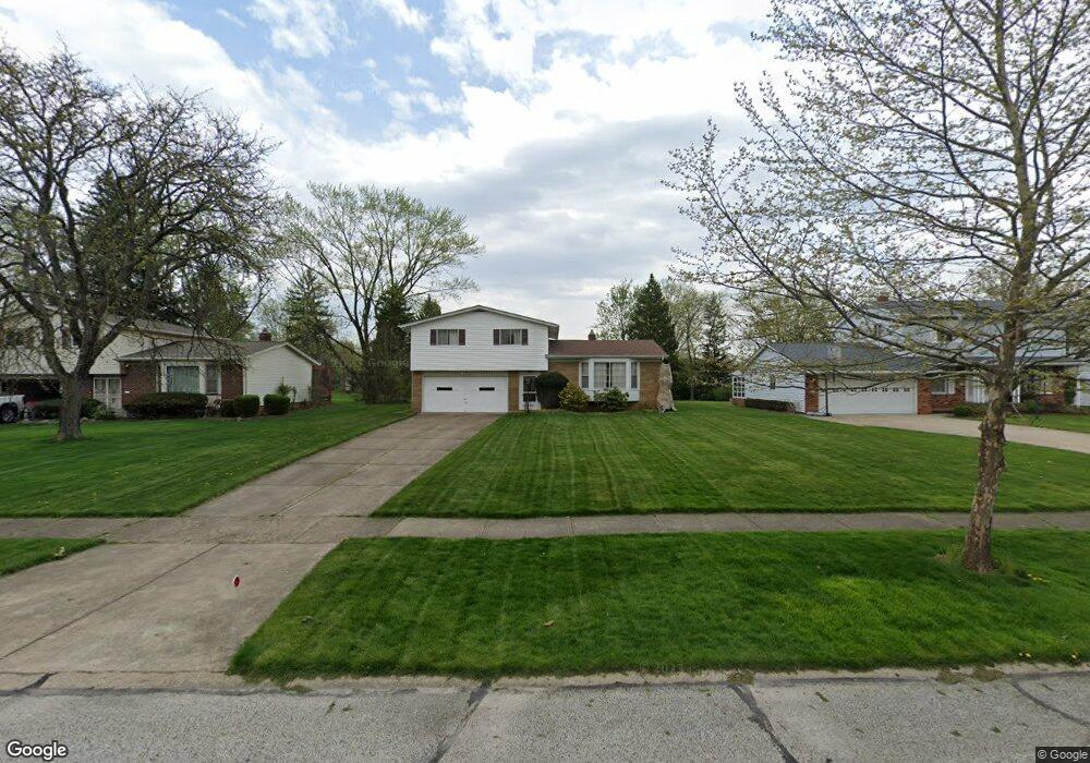
5403 Mardale Ave Bedford, OH 44146
Estimated Value: $166,000 - $206,000
3
Beds
2
Baths
1,559
Sq Ft
$123/Sq Ft
Est. Value
About This Home
This home is located at 5403 Mardale Ave, Bedford, OH 44146 and is currently estimated at $191,271, approximately $122 per square foot. 5403 Mardale Ave is a home located in Cuyahoga County with nearby schools including Heskett Middle School, Bedford High School, and Ohio College Preparatory School.
Ownership History
Date
Name
Owned For
Owner Type
Purchase Details
Closed on
Jan 4, 2013
Sold by
Musil Helen
Bought by
Musil Kenneth E
Current Estimated Value
Purchase Details
Closed on
Apr 1, 1985
Sold by
Helen Musil
Bought by
Musil Edward Fjr
Purchase Details
Closed on
Mar 9, 1981
Sold by
Musil Edward F
Bought by
Helen Musil
Purchase Details
Closed on
Nov 17, 1977
Sold by
Musil Edward F and Musil Helen
Bought by
Musil Edward F
Purchase Details
Closed on
Jan 1, 1975
Bought by
Musil Edward F and Musil Helen
Create a Home Valuation Report for This Property
The Home Valuation Report is an in-depth analysis detailing your home's value as well as a comparison with similar homes in the area
Home Values in the Area
Average Home Value in this Area
Purchase History
| Date | Buyer | Sale Price | Title Company |
|---|---|---|---|
| Musil Kenneth E | -- | Attorney | |
| Musil Edward Fjr | -- | -- | |
| Helen Musil | -- | -- | |
| Musil Edward F | -- | -- | |
| Musil Edward F | -- | -- |
Source: Public Records
Tax History
| Year | Tax Paid | Tax Assessment Tax Assessment Total Assessment is a certain percentage of the fair market value that is determined by local assessors to be the total taxable value of land and additions on the property. | Land | Improvement |
|---|---|---|---|---|
| 2024 | $3,292 | $56,000 | $12,320 | $43,680 |
| 2023 | $3,206 | $48,100 | $9,280 | $38,820 |
| 2022 | $2,833 | $48,090 | $9,280 | $38,820 |
| 2021 | $2,803 | $48,090 | $9,280 | $38,820 |
| 2020 | $2,429 | $39,410 | $7,600 | $31,820 |
| 2019 | $2,358 | $112,600 | $21,700 | $90,900 |
| 2018 | $2,344 | $39,410 | $7,600 | $31,820 |
| 2017 | $2,775 | $34,300 | $9,590 | $24,710 |
| 2016 | $2,753 | $34,300 | $9,590 | $24,710 |
| 2015 | $2,748 | $34,300 | $9,590 | $24,710 |
| 2014 | $2,748 | $34,300 | $9,590 | $24,710 |
Source: Public Records
Map
Nearby Homes
- 5424 Fairtree Rd
- 5385 Bartlett Rd
- 21607 Libby Rd
- 23100 Rockside Rd
- 21860 Louis Rd
- 21202 Gardenview Dr
- 21600 Franklin Rd
- 20648 Donny Brook Rd
- 21202 Hillgrove Ave
- 21207 Franklin Rd
- 20905 Clare Ave
- 20806 Clare Ave
- 54 Willard Ave
- 61 Hubbell Way
- 66 Hubbell Way
- 58 Hubbell Way
- 62 Hubbell Way
- 54 Hubbell Way
- 541 Helper Dr
- 57 Hubbell Way
- 5395 Mardale Ave
- 5411 Mardale Ave
- 5419 Mardale Ave
- 5387 Mardale Ave
- 5404 Fairtree Rd
- 5379 Mardale Ave
- 5427 Mardale Ave
- 5390 Fairtree Rd
- 5416 Fairtree Rd
- 5384 Fairtree Rd
- 5420 Fairtree Rd
- 5404 Mardale Ave
- 5412 Mardale Ave
- 5396 Mardale Ave
- 5371 Mardale Ave
- 5376 Fairtree Rd
- 5420 Mardale Ave
- 5388 Mardale Ave
- 5428 Mardale Ave
- 5380 Mardale Ave
Your Personal Tour Guide
Ask me questions while you tour the home.