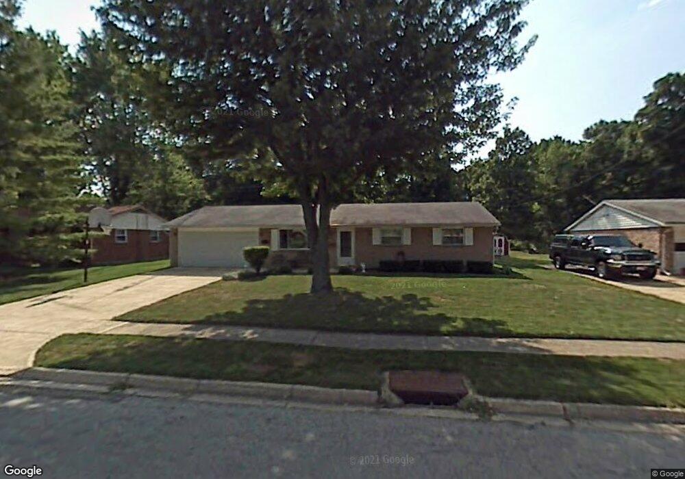
541 Damian St Vandalia, OH 45377
Estimated Value: $197,000 - $234,000
3
Beds
2
Baths
1,179
Sq Ft
$180/Sq Ft
Est. Value
About This Home
This home is located at 541 Damian St, Vandalia, OH 45377 and is currently estimated at $211,694, approximately $179 per square foot. 541 Damian St is a home located in Montgomery County with nearby schools including Helke Elementary School, Morton Middle School, and Butler High School.
Ownership History
Date
Name
Owned For
Owner Type
Purchase Details
Closed on
May 29, 2013
Sold by
Jordan Lytha E
Bought by
Miller Ronald E and Miller Michelle E
Current Estimated Value
Purchase Details
Closed on
Apr 20, 2001
Sold by
Jacobs Michael S and Jacobs Gina M
Bought by
Krieger Mary
Purchase Details
Closed on
Sep 11, 1997
Sold by
Koehl Debra L and Vernon Debra L
Bought by
Jacobs Michael S
Purchase Details
Closed on
May 24, 1994
Sold by
Koehl William M
Bought by
Koehl Debra L and Vernon Debra L
Create a Home Valuation Report for This Property
The Home Valuation Report is an in-depth analysis detailing your home's value as well as a comparison with similar homes in the area
Home Values in the Area
Average Home Value in this Area
Purchase History
| Date | Buyer | Sale Price | Title Company |
|---|---|---|---|
| Miller Ronald E | -- | Safemark Title | |
| Krieger Mary | $97,900 | -- | |
| Jacobs Michael S | $84,000 | -- | |
| Koehl Debra L | -- | -- |
Source: Public Records
Tax History Compared to Growth
Tax History
| Year | Tax Paid | Tax Assessment Tax Assessment Total Assessment is a certain percentage of the fair market value that is determined by local assessors to be the total taxable value of land and additions on the property. | Land | Improvement |
|---|---|---|---|---|
| 2024 | $2,744 | $52,480 | $12,200 | $40,280 |
| 2023 | $2,744 | $52,480 | $12,200 | $40,280 |
| 2022 | $2,460 | $38,030 | $8,840 | $29,190 |
| 2021 | $2,462 | $38,030 | $8,840 | $29,190 |
| 2020 | $2,457 | $38,030 | $8,840 | $29,190 |
| 2019 | $2,184 | $30,970 | $7,690 | $23,280 |
| 2018 | $2,188 | $30,970 | $7,690 | $23,280 |
| 2017 | $2,171 | $30,970 | $7,690 | $23,280 |
| 2016 | $2,176 | $30,500 | $7,690 | $22,810 |
| 2015 | $2,149 | $30,500 | $7,690 | $22,810 |
| 2014 | $2,149 | $30,500 | $7,690 | $22,810 |
| 2012 | -- | $33,760 | $8,540 | $25,220 |
Source: Public Records
Map
Nearby Homes
- 1072 Pool Ave
- 417 Randler Ave
- 926 Pool Ave
- 910 Bright Ave
- 808 Stewville Dr
- 1051 Bailey Ave
- 485 Pilot Point Unit 1-301
- 475 Pilot Point 1-300
- 465 Pilot Point 1-302
- 485 Pilot Point 1-301
- 475 Pilot Point Unit 1-300
- 860 Helke Rd
- 626 W National Rd
- 465 Pilot Point Unit 1-302
- 520 Buttercup Ave
- 1588 Middle Park Dr
- 25 Long St
- 246 Crest Hill Ave
- 3431 Mulberry Rd
- 917 Howard Ln