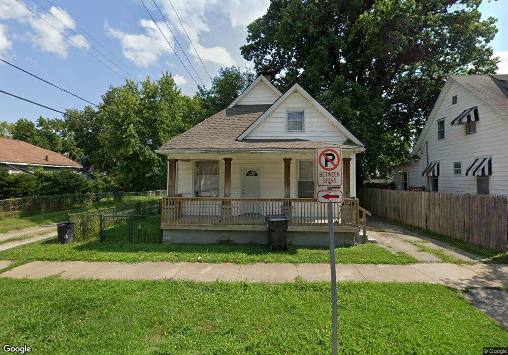
541 W Waggoner St Decatur, IL 62526
GM Square NeighborhoodEstimated Value: $36,301 - $50,000
3
Beds
2
Baths
2,004
Sq Ft
$22/Sq Ft
Est. Value
About This Home
This home is located at 541 W Waggoner St, Decatur, IL 62526 and is currently estimated at $44,075, approximately $21 per square foot. 541 W Waggoner St is a home located in Macon County with nearby schools including Parsons Elementary School, Stephen Decatur Middle School, and St. Patrick School.
Ownership History
Date
Name
Owned For
Owner Type
Purchase Details
Closed on
Dec 5, 2019
Sold by
Angel Capital Investment Group Llc
Bought by
Bourne Enterprises Llc
Current Estimated Value
Purchase Details
Closed on
Nov 21, 2016
Sold by
M And L Business Service Inc
Bought by
Angel Capital Investment Group Llc
Purchase Details
Closed on
Feb 28, 2013
Sold by
Brown Britt A
Bought by
M & L Business Services Inc
Purchase Details
Closed on
Nov 17, 2011
Sold by
Brown Atty Britt A
Bought by
Brown Atty Britt A
Purchase Details
Closed on
Nov 11, 2011
Sold by
Fronk Jody and Fronk Kathy
Bought by
Lincoln Land Illinois Land Trust
Purchase Details
Closed on
Mar 22, 2007
Sold by
Lloyd Jeff
Bought by
Fronk Jody and Fronk Kathy
Purchase Details
Closed on
Apr 1, 1991
Create a Home Valuation Report for This Property
The Home Valuation Report is an in-depth analysis detailing your home's value as well as a comparison with similar homes in the area
Home Values in the Area
Average Home Value in this Area
Purchase History
| Date | Buyer | Sale Price | Title Company |
|---|---|---|---|
| Bourne Enterprises Llc | $28,000 | None Available | |
| Angel Capital Investment Group Llc | -- | Attorney | |
| M & L Business Services Inc | -- | None Available | |
| Brown Atty Britt A | $17,500 | None Available | |
| Lincoln Land Illinois Land Trust | $17,500 | None Available | |
| Lincoln Land Illinois Land Trust | -- | None Available | |
| Fronk Jody | -- | None Available | |
| -- | $12,000 | -- |
Source: Public Records
Tax History Compared to Growth
Tax History
| Year | Tax Paid | Tax Assessment Tax Assessment Total Assessment is a certain percentage of the fair market value that is determined by local assessors to be the total taxable value of land and additions on the property. | Land | Improvement |
|---|---|---|---|---|
| 2024 | $590 | $6,092 | $437 | $5,655 |
| 2023 | $585 | $5,877 | $422 | $5,455 |
| 2022 | $564 | $5,515 | $390 | $5,125 |
| 2021 | $530 | $5,151 | $365 | $4,786 |
| 2020 | $522 | $4,912 | $349 | $4,563 |
| 2019 | $522 | $4,912 | $349 | $4,563 |
| 2018 | $555 | $5,285 | $198 | $5,087 |
| 2017 | $568 | $5,426 | $203 | $5,223 |
| 2016 | $579 | $5,481 | $205 | $5,276 |
| 2015 | $630 | $6,162 | $135 | $6,027 |
| 2014 | $589 | $6,101 | $134 | $5,967 |
| 2013 | $604 | $6,330 | $139 | $6,191 |
Source: Public Records
Map
Nearby Homes
- 1504 N Monroe St
- 1545 N Monroe St
- 837 W Grand Ave
- 644 W Division St
- 1245 N Union St
- 1653 N Maple Ave
- 933 W Division St
- 1915 N Monroe St
- 1558 N Main St
- 1568 N Main St
- 844 N Edward St
- 141 E Packard St
- 230 W Garfield Ave
- 216 W Garfield Ave
- 415 W Green St
- 875 N Monroe St
- 240 E Olive St
- 1065 W Green St
- 1319 W Waggoner St
- 917 N Wilder Ave
- 551 W Waggoner St
- 1368 N Monroe St
- 1406 N Monroe St
- 535 W Waggoner St
- 1378 N Monroe St
- 560 W Waggoner St
- 1363 N College St
- 1348 N Monroe St
- 1355 N College St
- 1369 N College St
- 1402 N Monroe St
- 1408 N Monroe St
- 1407 N College St
- 1345 N College St
- 1412 N Monroe St
- 1419 N College St
- 1328 N Monroe St
- 1428 N Monroe St
- 1322 N Monroe St
- 1415 N College St