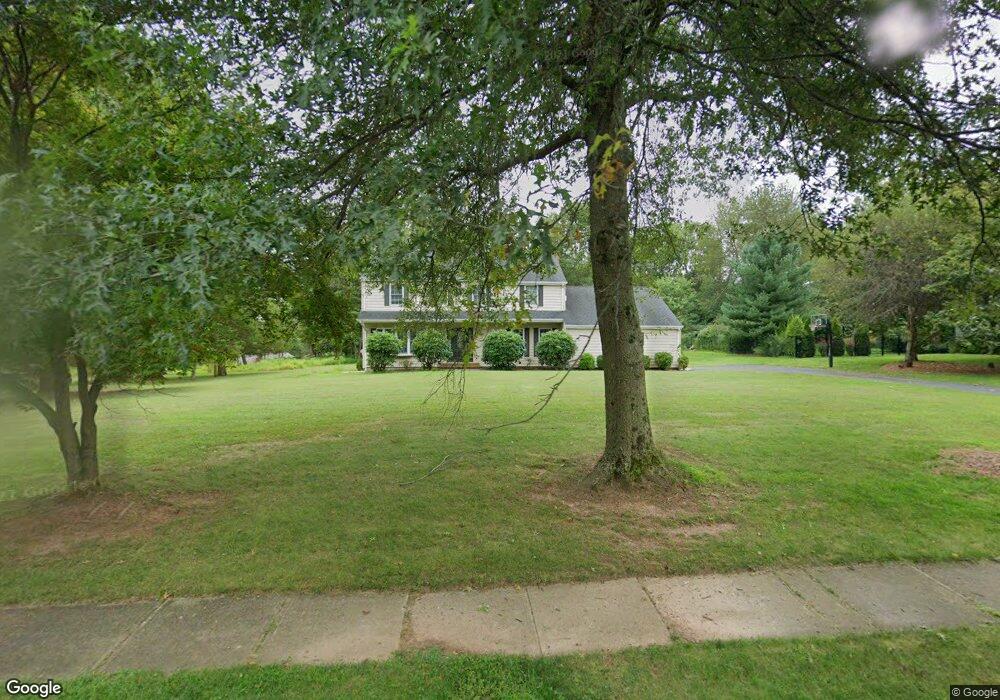
541 Wren Way Branchburg, NJ 08876
Branchburg Township NeighborhoodEstimated Value: $799,000 - $1,006,000
--
Bed
--
Bath
2,979
Sq Ft
$292/Sq Ft
Est. Value
About This Home
This home is located at 541 Wren Way, Branchburg, NJ 08876 and is currently estimated at $869,551, approximately $291 per square foot. 541 Wren Way is a home located in Somerset County with nearby schools including Whiton Elementary School, Stony Brook School, and Branchburg Central Middle School.
Ownership History
Date
Name
Owned For
Owner Type
Purchase Details
Closed on
Jul 23, 2010
Sold by
Willard William and Willard Tracy R
Bought by
Willard William J and Willard Tracy R
Current Estimated Value
Home Financials for this Owner
Home Financials are based on the most recent Mortgage that was taken out on this home.
Original Mortgage
$249,560
Interest Rate
4.78%
Mortgage Type
New Conventional
Purchase Details
Closed on
Jun 3, 2002
Sold by
Bolton Michael
Bought by
Willard William and Rohan Tracy
Home Financials for this Owner
Home Financials are based on the most recent Mortgage that was taken out on this home.
Original Mortgage
$340,000
Interest Rate
6.9%
Purchase Details
Closed on
Nov 19, 1990
Sold by
Ong Chung-Jian and Ong Shih-May
Bought by
Bolton Michael D and Bolton Anne H
Create a Home Valuation Report for This Property
The Home Valuation Report is an in-depth analysis detailing your home's value as well as a comparison with similar homes in the area
Home Values in the Area
Average Home Value in this Area
Purchase History
| Date | Buyer | Sale Price | Title Company |
|---|---|---|---|
| Willard William J | -- | Chicago Title Insurance Co | |
| Willard William | $425,000 | -- | |
| Bolton Michael D | $235,000 | -- |
Source: Public Records
Mortgage History
| Date | Status | Borrower | Loan Amount |
|---|---|---|---|
| Closed | Willard William J | $249,560 | |
| Closed | Willard William | $340,000 |
Source: Public Records
Tax History Compared to Growth
Tax History
| Year | Tax Paid | Tax Assessment Tax Assessment Total Assessment is a certain percentage of the fair market value that is determined by local assessors to be the total taxable value of land and additions on the property. | Land | Improvement |
|---|---|---|---|---|
| 2025 | $12,282 | $742,900 | $194,700 | $548,200 |
| 2024 | $12,282 | $680,800 | $194,700 | $486,100 |
| 2023 | $11,673 | $623,900 | $194,700 | $429,200 |
| 2022 | $11,749 | $596,700 | $194,700 | $402,000 |
| 2021 | $10,396 | $499,400 | $194,700 | $304,700 |
| 2020 | $10,396 | $485,100 | $194,700 | $290,400 |
| 2019 | $10,370 | $481,200 | $194,700 | $286,500 |
| 2018 | $10,189 | $471,500 | $194,700 | $276,800 |
| 2017 | $9,966 | $458,000 | $184,700 | $273,300 |
| 2016 | $10,004 | $456,800 | $179,700 | $277,100 |
| 2015 | $9,975 | $456,300 | $169,800 | $286,500 |
| 2014 | $9,722 | $450,100 | $159,800 | $290,300 |
Source: Public Records
Map
Nearby Homes
- 5 Walnut Dr
- 507 Dunn Cir
- 19 Craft Farm Dr
- 3010 Doolittle Dr
- 2801 Doolittle Dr
- 6 Heritage Ct
- 215 Readington Rd
- 48 Reinhart Way
- 2104 Doolittle Dr
- 2512 Lindsley Rd
- 4101 Dilts Ln
- 2008 Ackmen Ct
- 61 Waugh Ct
- 2 Carlisle Rd
- 511 Red Crest Ln
- 1601 Breckenridge Dr
- 2706 Pinhorn Dr
- 203 Red Crest Ln
- 232 River Rd
- 3214 Winder Dr