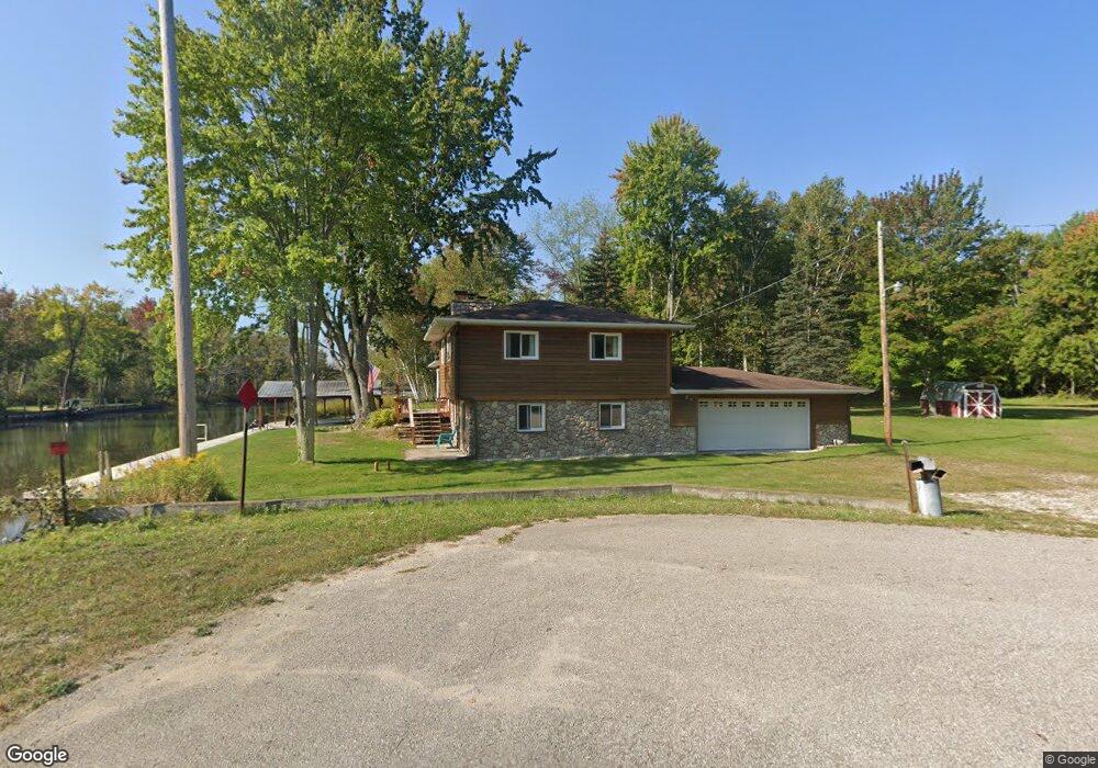
5410 Snider Rd Brutus, MI 49716
Estimated Value: $474,198 - $702,000
Studio
--
Bath
1,920
Sq Ft
$303/Sq Ft
Est. Value
About This Home
This home is located at 5410 Snider Rd, Brutus, MI 49716 and is currently estimated at $581,550, approximately $302 per square foot. 5410 Snider Rd is a home located in Emmet County with nearby schools including Alanson Public School.
Ownership History
Date
Name
Owned For
Owner Type
Purchase Details
Closed on
Dec 22, 2014
Sold by
Elto Leatrice L and Elto Patrick W
Bought by
Elto Leatrice L and Leatrice L Elto Trust Uad 12/2
Current Estimated Value
Purchase Details
Closed on
Aug 17, 2007
Sold by
Underwood Leslie L and Underwood Jana
Bought by
Elto Patrick W and Elto Leatrice L
Home Financials for this Owner
Home Financials are based on the most recent Mortgage that was taken out on this home.
Original Mortgage
$200,000
Outstanding Balance
$127,469
Interest Rate
6.79%
Estimated Equity
$454,081
Create a Home Valuation Report for This Property
The Home Valuation Report is an in-depth analysis detailing your home's value as well as a comparison with similar homes in the area
Purchase History
| Date | Buyer | Sale Price | Title Company |
|---|---|---|---|
| Elto Leatrice L | -- | -- | |
| Elto Patrick W | $290,000 | -- |
Source: Public Records
Mortgage History
| Date | Status | Borrower | Loan Amount |
|---|---|---|---|
| Open | Elto Patrick W | $200,000 |
Source: Public Records
Tax History
| Year | Tax Paid | Tax Assessment Tax Assessment Total Assessment is a certain percentage of the fair market value that is determined by local assessors to be the total taxable value of land and additions on the property. | Land | Improvement |
|---|---|---|---|---|
| 2025 | $5,222 | $208,600 | $3,600 | $205,000 |
| 2024 | $38 | $190,000 | $3,600 | $186,400 |
| 2023 | $4,702 | $202,800 | $2,300 | $200,500 |
| 2022 | $4,702 | $126,800 | $2,200 | $124,600 |
| 2021 | $4,563 | $127,400 | $2,200 | $125,200 |
| 2020 | $4,480 | $129,300 | $0 | $129,300 |
| 2019 | -- | $130,800 | $19,900 | $110,900 |
| 2018 | -- | $131,100 | $19,900 | $111,200 |
| 2017 | -- | $133,500 | $19,900 | $113,600 |
| 2016 | -- | $120,000 | $19,900 | $100,100 |
| 2015 | -- | $107,100 | $0 | $0 |
| 2014 | -- | $101,000 | $0 | $0 |
Source: Public Records
Map
Nearby Homes
- 7028 Barney Rd
- 4333 U S 31
- 7325 Keystone Park Dr Unit 18
- 7328 Keystone Park Dr Unit Lot 12
- 6167 Lambert Dr
- 7486 Keystone Park Dr Unit Lot 30
- 7300 Michigan 68
- 6737 Honeysette Rd
- 7287 Spring St
- TBD Spring St
- VL Spring St
- 7084 Center St
- 7181 Maple St
- 6672 San Juan Unit 80
- 0 Michigan 68 Unit 201834858
- TBD Miller Rd Unit LOTS : 10;11;15;17;1
- 8688 Miller Rd
- 6320 & 6332 River St
- 8842 Chickadee Ln Unit Lot 12
- 8118 Miller Rd Unit Lot 19
- 8005 Marathon Way
- 8017 Marathon Way
- 5464 Mission Rd
- 5464 Mission Rd Unit .84 acres
- 8029 Marathon Way
- 8030 Devils Elbow Dr
- 8051 Marathon Way
- 5486 Mission Rd
- 8040 Devils Elbow Dr
- 8065 Marathon Way
- 8050 Marathon Way
- 8050 Devils Elbow Dr
- 8077 Marathon Way
- 8105 Marathon Way
- 8060 Devils Elbow Dr
- 8060 Devils Elbow Dr
- 8111 Marathon Way
- 8070 Devils Elbow Dr
- 8118 Marathon Way
- 8121 Marathon Way
Your Personal Tour Guide
Ask me questions while you tour the home.