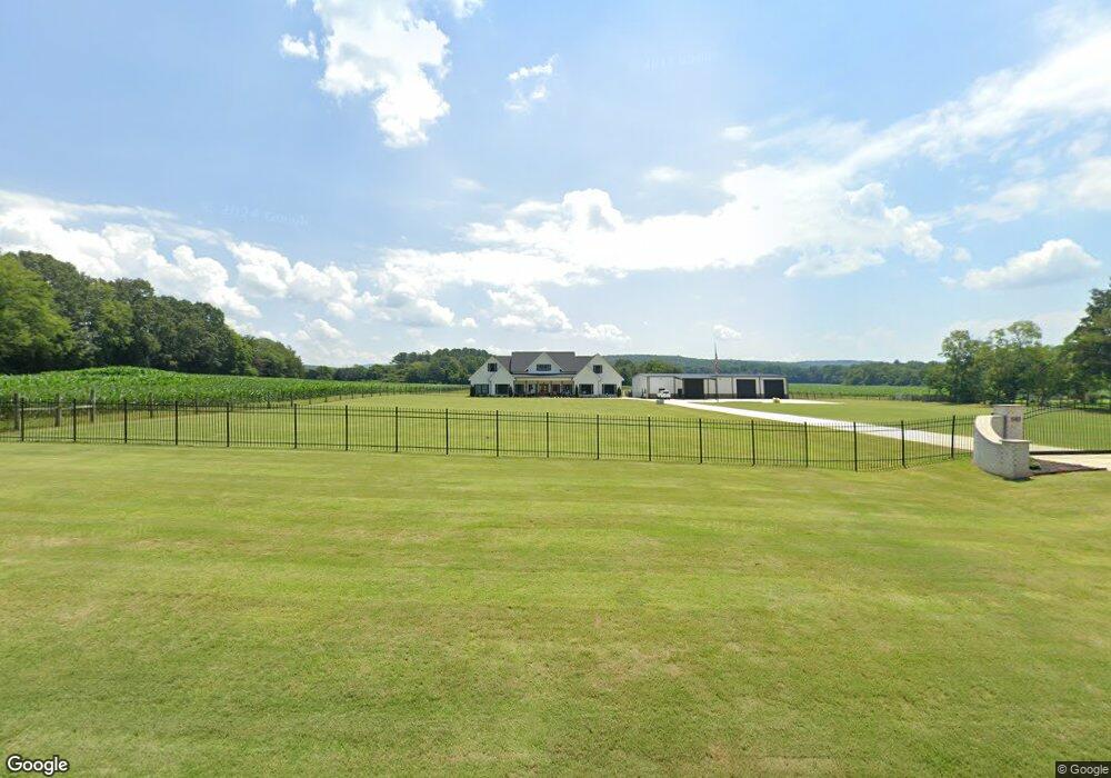
5413 Maysville Rd New Market, AL 35761
Estimated Value: $246,000 - $688,613
--
Bed
--
Bath
--
Sq Ft
7.3
Acres
About This Home
This home is located at 5413 Maysville Rd, New Market, AL 35761 and is currently estimated at $455,538. 5413 Maysville Rd is a home with nearby schools including Riverton Elementary School, Riverton Intermediate School, and Buckhorn Middle School.
Ownership History
Date
Name
Owned For
Owner Type
Purchase Details
Closed on
Nov 28, 2022
Sold by
Campbell Carl S and Campbell Gwendolyn E
Bought by
Carl And Gwendolyn Campbell Management Trust
Current Estimated Value
Purchase Details
Closed on
Aug 6, 2014
Sold by
Nettles Bill L
Bought by
Peoples Blank E and Peoples Doris Green
Purchase Details
Closed on
Oct 5, 2013
Sold by
Erwin Allie J
Bought by
Graham Freda
Purchase Details
Closed on
Aug 18, 2008
Sold by
Erwin Allie J
Bought by
Peoples Blank and Peoples Doris
Create a Home Valuation Report for This Property
The Home Valuation Report is an in-depth analysis detailing your home's value as well as a comparison with similar homes in the area
Home Values in the Area
Average Home Value in this Area
Purchase History
| Date | Buyer | Sale Price | Title Company |
|---|---|---|---|
| Carl And Gwendolyn Campbell Management Trust | -- | -- | |
| Peoples Blank E | $70,000 | None Available | |
| Graham Freda | $1,000 | None Available | |
| Peoples Blank | -- | -- |
Source: Public Records
Tax History Compared to Growth
Tax History
| Year | Tax Paid | Tax Assessment Tax Assessment Total Assessment is a certain percentage of the fair market value that is determined by local assessors to be the total taxable value of land and additions on the property. | Land | Improvement |
|---|---|---|---|---|
| 2024 | $2,596 | $71,680 | $11,320 | $60,360 |
| 2023 | $2,534 | $68,900 | $11,320 | $57,580 |
| 2022 | $2,195 | $61,100 | $8,600 | $52,500 |
| 2021 | $220 | $6,580 | $6,580 | $0 |
| 2020 | $220 | $6,570 | $6,570 | $0 |
| 2019 | $220 | $6,570 | $6,570 | $0 |
| 2018 | $208 | $6,220 | $0 | $0 |
| 2017 | $208 | $6,220 | $0 | $0 |
| 2016 | $208 | $6,220 | $0 | $0 |
| 2015 | $208 | $6,220 | $0 | $0 |
| 2014 | $13 | $400 | $0 | $0 |
Source: Public Records
Map
Nearby Homes
- The McGinnis Roman Randall Rd
- The Piedmont Roman Randall Rd
- 102 Khloiey Hopes Ln
- The Avery Roman Randall Rd
- The Avondale Roman Randall Rd
- The Benson II Roman Randall Rd
- 106 Khloiey Hopes Ln
- The Harrington Roman Randall Rd
- 277 Roman Randall Rd
- 100 Khloiey Hopes Ln
- 216 Roman Randall Rd
- 227 Roman Randall Rd
- 225 Roman Randall Rd
- 218 Roman Randall Rd
- 214 Roman Randall Rd
- 212 Roman Randall Rd
- 209 Roman Randall Rd
- 215 Roman Randall Rd
- 210 Roman Randall Rd
- 1682 B Plan at McMullen Gardens
- 5453 Maysville Rd
- 5438 Maysville Rd
- 5430 Maysville Rd
- 5463 Maysville Rd
- 5414 Maysville Rd
- 5383 Maysville Rd
- 211 Roman Randall Rd
- 5509 Maysville Rd
- 205 Roman Randall Rd Unit 36765829
- 5521 Maysville Rd
- 303 Creek Grove Ave
- 305 Creek Grove Ave
- 307 Creek Grove Ave
- 309 Creek Grove Ave
- 311 Creek Grove Ave
- 313 Creek Grove Ave Unit 2697961-59445
- 315 Creek Grove Ave
- 306 Creek Grove Ave
- 308 Creek Grove Ave
- 310 Creek Grove Ave