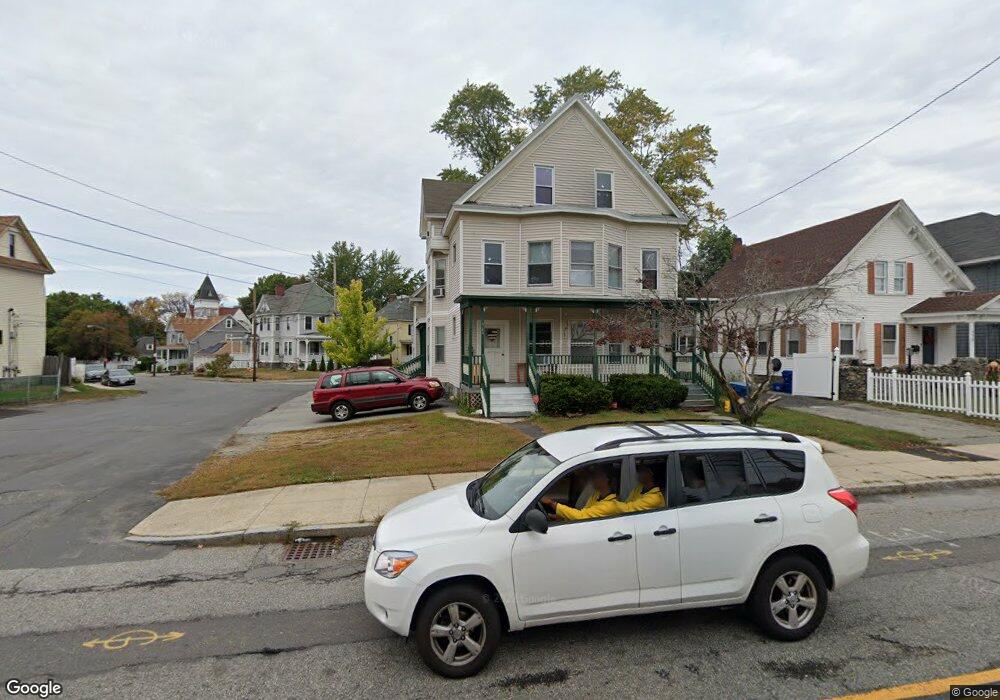
542 Andover St Unit 544 Lawrence, MA 01843
South West NeighborhoodEstimated Value: $725,976 - $896,000
8
Beds
3
Baths
3,299
Sq Ft
$248/Sq Ft
Est. Value
About This Home
This home is located at 542 Andover St Unit 544, Lawrence, MA 01843 and is currently estimated at $819,494, approximately $248 per square foot. 542 Andover St Unit 544 is a home located in Essex County with nearby schools including John Breen School, Emily G. Wetherbee School (K-8), and School For Exceptional Studies.
Ownership History
Date
Name
Owned For
Owner Type
Purchase Details
Closed on
May 3, 2012
Sold by
Cruz Dilcia
Bought by
Tuyen Mui
Current Estimated Value
Purchase Details
Closed on
Jul 26, 1999
Sold by
Lira Nestor J and Lira Nestor J
Bought by
Cruz Dilcia
Home Financials for this Owner
Home Financials are based on the most recent Mortgage that was taken out on this home.
Original Mortgage
$129,000
Interest Rate
7.49%
Mortgage Type
Purchase Money Mortgage
Create a Home Valuation Report for This Property
The Home Valuation Report is an in-depth analysis detailing your home's value as well as a comparison with similar homes in the area
Home Values in the Area
Average Home Value in this Area
Purchase History
| Date | Buyer | Sale Price | Title Company |
|---|---|---|---|
| Tuyen Mui | $188,000 | -- | |
| Cruz Dilcia | $129,000 | -- |
Source: Public Records
Mortgage History
| Date | Status | Borrower | Loan Amount |
|---|---|---|---|
| Previous Owner | Cruz Dilcia | $129,000 | |
| Previous Owner | Cruz Dilcia | $18,000 |
Source: Public Records
Tax History
| Year | Tax Paid | Tax Assessment Tax Assessment Total Assessment is a certain percentage of the fair market value that is determined by local assessors to be the total taxable value of land and additions on the property. | Land | Improvement |
|---|---|---|---|---|
| 2025 | $5,659 | $643,100 | $106,400 | $536,700 |
| 2024 | $5,434 | $587,500 | $115,200 | $472,300 |
| 2023 | $5,585 | $549,700 | $106,800 | $442,900 |
| 2022 | $5,214 | $455,800 | $96,800 | $359,000 |
| 2021 | $5,074 | $413,500 | $96,800 | $316,700 |
| 2020 | $4,879 | $392,500 | $91,800 | $300,700 |
| 2019 | $4,638 | $339,000 | $76,200 | $262,800 |
| 2018 | $4,237 | $295,900 | $72,200 | $223,700 |
| 2017 | $3,922 | $255,700 | $68,300 | $187,400 |
| 2016 | $3,846 | $248,000 | $56,200 | $191,800 |
| 2015 | $3,774 | $249,600 | $56,200 | $193,400 |
Source: Public Records
Map
Nearby Homes
- 543 Andover St Unit 6
- 33-35 Coolidge St
- 37 Tewksbury St Unit 39
- 91-93 Newton St
- 49 Bowdoin St Unit 51
- 11 W Hawley St
- 312 Water St Unit 4
- 87-87A Brookfield St
- 18 Doyle St
- 35 Adams St
- 82 S Broadway
- 24 Inman St Unit 4
- 341 S Broadway- Parcel II
- 19 Oregon Ave
- 31 Garfield St
- 82 Water St
- 27-29 Dorchester St
- 12B Stevens St
- 100 Bailey St Unit 1
- 100 Bailey St Unit 3
- 542 Andover St Unit 1
- 538 Andover St
- 534 Andover St Unit 536
- 546 Andover St Unit 548
- 64 Bigelow St
- 530 Andover St
- 545 Andover St
- 71 Bigelow St
- 537 Andover St
- 91 Belknap St
- 552 Andover St
- 89 Belknap St
- 69 Bigelow St
- 58 Bigelow St
- 58 Bigelow St Unit 3
- 58 Bigelow St Unit 2
- 528 Andover St
- 533 Andover St Unit 535
- 63 Bigelow St
- 54 Bigelow St
Your Personal Tour Guide
Ask me questions while you tour the home.