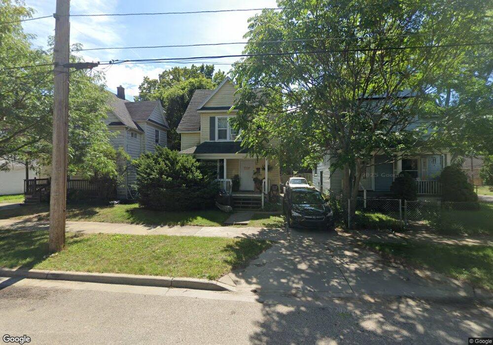
542 Curtis St NE Grand Rapids, MI 49505
Creston NeighborhoodEstimated Value: $226,000 - $256,000
3
Beds
2
Baths
1,187
Sq Ft
$203/Sq Ft
Est. Value
About This Home
This home is located at 542 Curtis St NE, Grand Rapids, MI 49505 and is currently estimated at $240,941, approximately $202 per square foot. 542 Curtis St NE is a home located in Kent County with nearby schools including Kent Hills School, Riverside Middle School, and Union High School.
Ownership History
Date
Name
Owned For
Owner Type
Purchase Details
Closed on
Aug 18, 2000
Sold by
Woods Oddy
Bought by
Woods and Woods Jacksn
Current Estimated Value
Purchase Details
Closed on
Feb 24, 1993
Sold by
Molhoek Molhoek M M and Molhoek Oddy T
Bought by
Woods Percy C Jr
Purchase Details
Closed on
Nov 6, 1985
Bought by
Woods Percy C Jr
Purchase Details
Closed on
Oct 21, 1985
Bought by
Woods Percy C Jr
Create a Home Valuation Report for This Property
The Home Valuation Report is an in-depth analysis detailing your home's value as well as a comparison with similar homes in the area
Home Values in the Area
Average Home Value in this Area
Purchase History
| Date | Buyer | Sale Price | Title Company |
|---|---|---|---|
| Woods | $85,800 | -- | |
| Woods Percy C Jr | $47,900 | -- | |
| Woods Percy C Jr | $29,400 | -- | |
| Woods Percy C Jr | $20,000 | -- |
Source: Public Records
Tax History Compared to Growth
Tax History
| Year | Tax Paid | Tax Assessment Tax Assessment Total Assessment is a certain percentage of the fair market value that is determined by local assessors to be the total taxable value of land and additions on the property. | Land | Improvement |
|---|---|---|---|---|
| 2025 | $1,179 | $95,900 | $0 | $0 |
| 2024 | $1,179 | $85,200 | $0 | $0 |
| 2023 | $1,196 | $78,900 | $0 | $0 |
| 2022 | $1,136 | $69,800 | $0 | $0 |
| 2021 | $1,110 | $61,600 | $0 | $0 |
| 2020 | $1,062 | $53,600 | $0 | $0 |
| 2019 | $1,074 | $50,700 | $0 | $0 |
| 2018 | $1,074 | $45,300 | $0 | $0 |
| 2017 | $1,045 | $35,300 | $0 | $0 |
| 2016 | $1,058 | $30,900 | $0 | $0 |
| 2015 | $984 | $30,900 | $0 | $0 |
| 2013 | -- | $29,300 | $0 | $0 |
Source: Public Records
Map
Nearby Homes
- 1360 Union Ave NE
- 1410 Union Ave NE
- 532 Carrier St NE
- 443 Quimby St NE
- 1402 North Ave NE
- 1144 Union Ave NE
- 1516 Cole Ave NE
- 330 Page St NE
- 327 Carrier St NE
- 327 Quimby St NE
- 1420 Buffalo Ave NE
- 1215 Emerald Ave NE
- 255 Barnett St NE
- 310 Sweet St NE
- 527 Cedar St NE
- 1047 Eastern Ave NE
- 852 Leonard St NE
- 1032 Lafayette Ave NE
- 212 Saunders Ct NE
- 126 Page St NE
- 544 Curtis St NE
- 538 Curtis St NE
- 1314 Paris Ave NE
- 1325 Union Ave NE
- 1319 Union Ave NE
- 1310 Paris Ave NE
- 1315 Union Ave NE
- 545 Curtis St NE
- 539 Curtis St NE
- 1309 Union Ave NE
- 1304 Paris Ave NE
- 530 Curtis St NE
- 1317 Paris Ave NE
- 1335 Union Ave NE
- 1315 Paris Ave NE
- 1305 Union Ave NE
- 1309 Paris Ave NE
- 1339 Union Ave NE
- 1264 Paris Ave NE
- 1342 Paris Ave NE