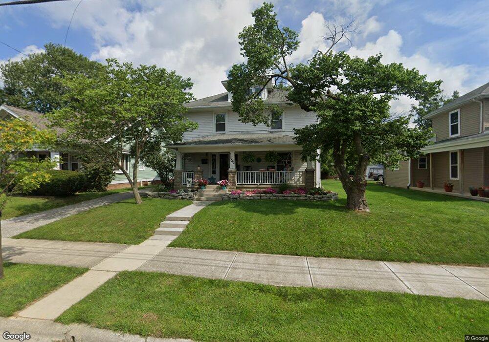
542 E 5th St Marysville, OH 43040
Estimated Value: $273,000 - $338,000
5
Beds
2
Baths
2,224
Sq Ft
$134/Sq Ft
Est. Value
About This Home
This home is located at 542 E 5th St, Marysville, OH 43040 and is currently estimated at $298,151, approximately $134 per square foot. 542 E 5th St is a home located in Union County with nearby schools including Northwood Elementary School, Creekview Intermediate Elementary School, and Bunsold Middle School.
Ownership History
Date
Name
Owned For
Owner Type
Purchase Details
Closed on
Jan 21, 2020
Sold by
Medici Brett A
Bought by
Vigar Willis Properties Llc
Current Estimated Value
Purchase Details
Closed on
May 23, 2000
Sold by
Shrf Kay Jones Pr
Bought by
Secretary Of Housing & Urban Dev
Purchase Details
Closed on
Mar 25, 1997
Sold by
Smucker Ralph E
Bought by
Jones Kay A
Home Financials for this Owner
Home Financials are based on the most recent Mortgage that was taken out on this home.
Original Mortgage
$109,918
Interest Rate
7.82%
Mortgage Type
FHA
Purchase Details
Closed on
Jan 14, 1997
Sold by
Bank Of America Trst
Bought by
Smucker Ralph E
Purchase Details
Closed on
Aug 26, 1996
Sold by
Shrf Jack E Wilson Pr
Bought by
Bank Of America Illinois Trustee
Create a Home Valuation Report for This Property
The Home Valuation Report is an in-depth analysis detailing your home's value as well as a comparison with similar homes in the area
Home Values in the Area
Average Home Value in this Area
Purchase History
| Date | Buyer | Sale Price | Title Company |
|---|---|---|---|
| Vigar Willis Properties Llc | $127,000 | None Available | |
| Secretary Of Housing & Urban Dev | $66,667 | -- | |
| Jones Kay A | $112,000 | -- | |
| Smucker Ralph E | $65,000 | -- | |
| Bank Of America Illinois Trustee | $62,000 | -- |
Source: Public Records
Mortgage History
| Date | Status | Borrower | Loan Amount |
|---|---|---|---|
| Previous Owner | Jones Kay A | $109,918 |
Source: Public Records
Tax History Compared to Growth
Tax History
| Year | Tax Paid | Tax Assessment Tax Assessment Total Assessment is a certain percentage of the fair market value that is determined by local assessors to be the total taxable value of land and additions on the property. | Land | Improvement |
|---|---|---|---|---|
| 2024 | $3,290 | $76,940 | $8,630 | $68,310 |
| 2023 | $3,290 | $76,940 | $8,630 | $68,310 |
| 2022 | $3,233 | $76,940 | $8,630 | $68,310 |
| 2021 | $2,137 | $44,450 | $6,630 | $37,820 |
| 2020 | $2,228 | $44,450 | $6,630 | $37,820 |
| 2019 | $3,113 | $65,730 | $6,630 | $59,100 |
| 2018 | $2,181 | $42,880 | $6,630 | $36,250 |
| 2017 | $2,132 | $42,880 | $6,630 | $36,250 |
| 2016 | $2,125 | $42,880 | $6,630 | $36,250 |
| 2015 | $2,038 | $38,460 | $6,630 | $31,830 |
| 2014 | $2,038 | $38,460 | $6,630 | $31,830 |
| 2013 | $1,919 | $38,460 | $6,630 | $31,830 |
Source: Public Records
Map
Nearby Homes
- 627 E 6th St
- 125 S Oak St
- 226 S Plum St
- 203 W 3rd St
- 158C Tulip Dr
- 260 W 4th St
- 256 W 3rd St
- 569 E 10th St Unit 1A
- 78 Aspen Dr
- 448 Professional Pkwy
- 718 N Main St
- 525 Ash St
- 0 Columbus Ave
- 226 Elwood Ave
- 0 Square Dr
- 733 N Maple St
- 651 Millcrest Dr Unit 651A
- 1145 Coventry Way Unit D
- 1055 Greenfield Dr
- 15760 Watkins Rd