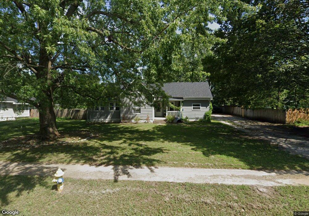
542 N Main St Republic, MO 65738
Estimated Value: $178,333 - $214,000
3
Beds
2
Baths
1,416
Sq Ft
$134/Sq Ft
Est. Value
About This Home
This home is located at 542 N Main St, Republic, MO 65738 and is currently estimated at $189,083, approximately $133 per square foot. 542 N Main St is a home located in Greene County with nearby schools including Schofield Elementary School, Republic Middle School, and Republic High School.
Ownership History
Date
Name
Owned For
Owner Type
Purchase Details
Closed on
Oct 1, 2011
Sold by
Kamplain Justin W and Kamplain April D
Bought by
Summers Michael
Current Estimated Value
Purchase Details
Closed on
Aug 6, 2010
Sold by
Broaddus Cody and Broaddus Tasha
Bought by
Kamplain Justin W and Kamplain April D
Home Financials for this Owner
Home Financials are based on the most recent Mortgage that was taken out on this home.
Original Mortgage
$88,804
Interest Rate
4.87%
Mortgage Type
FHA
Purchase Details
Closed on
Feb 26, 2007
Sold by
Hamilton Basil and Hamilton Bess
Bought by
Broaddus Cody and Howerton Tasha
Home Financials for this Owner
Home Financials are based on the most recent Mortgage that was taken out on this home.
Original Mortgage
$85,025
Interest Rate
6.17%
Mortgage Type
New Conventional
Purchase Details
Closed on
Apr 20, 2006
Sold by
Wells Fargo Bank Minnesota Na
Bought by
Home Equity Loan Trust
Purchase Details
Closed on
Feb 10, 2006
Sold by
Millsap & Singer Pc
Bought by
Well Fargo Bank Na
Create a Home Valuation Report for This Property
The Home Valuation Report is an in-depth analysis detailing your home's value as well as a comparison with similar homes in the area
Home Values in the Area
Average Home Value in this Area
Purchase History
| Date | Buyer | Sale Price | Title Company |
|---|---|---|---|
| Summers Michael | -- | None Available | |
| Kamplain Justin W | -- | None Available | |
| Broaddus Cody | -- | None Available | |
| Home Equity Loan Trust | -- | None Available | |
| Well Fargo Bank Na | -- | None Available |
Source: Public Records
Mortgage History
| Date | Status | Borrower | Loan Amount |
|---|---|---|---|
| Previous Owner | Kamplain Justin W | $88,804 | |
| Previous Owner | Broaddus Cody | $85,025 |
Source: Public Records
Tax History Compared to Growth
Tax History
| Year | Tax Paid | Tax Assessment Tax Assessment Total Assessment is a certain percentage of the fair market value that is determined by local assessors to be the total taxable value of land and additions on the property. | Land | Improvement |
|---|---|---|---|---|
| 2025 | $838 | $17,010 | $5,700 | $11,310 |
| 2024 | $838 | $15,010 | $4,750 | $10,260 |
| 2023 | $822 | $15,010 | $4,750 | $10,260 |
| 2022 | $786 | $14,270 | $4,750 | $9,520 |
| 2021 | $781 | $14,270 | $4,750 | $9,520 |
| 2020 | $793 | $14,270 | $4,750 | $9,520 |
| 2019 | $791 | $14,270 | $4,750 | $9,520 |
| 2018 | $747 | $13,030 | $3,800 | $9,230 |
| 2017 | $741 | $12,290 | $3,800 | $8,490 |
| 2016 | $707 | $12,290 | $3,800 | $8,490 |
| 2015 | $704 | $12,290 | $3,800 | $8,490 |
| 2014 | $709 | $12,270 | $3,800 | $8,470 |
Source: Public Records
Map
Nearby Homes
- 533 N Main St
- 532 N College Ave
- 520 N College Ave
- 1213 N London Place
- 626 N Phelps Ave
- 707 N College Ave
- 347 W Elm St
- 923 N Travis Ave
- 135 N Bonnie Ave
- 00 N Boston Ln
- 1128 N Blackstone Ave
- 1169 N Blackstone Ave
- 285 E Garnet Dr
- 207 W Broad St
- 217 E Ritter St
- 401 Ethan Ave
- 0 Highway 60 Unit 60308100
- 0 Highway 60 Unit 60308095
- 219 E Kelce Ln
- 1015 N Lindsey Ave Unit Lot 13