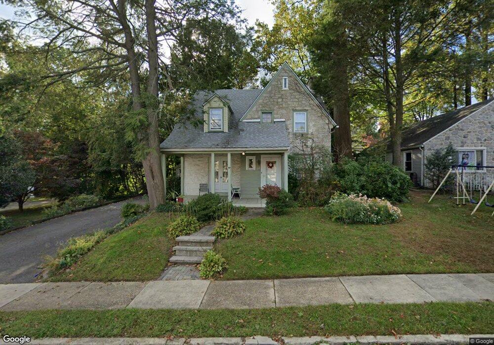
542 Netherwood Rd Upper Darby, PA 19082
Estimated Value: $330,792 - $439,000
3
Beds
2
Baths
2,164
Sq Ft
$178/Sq Ft
Est. Value
About This Home
This home is located at 542 Netherwood Rd, Upper Darby, PA 19082 and is currently estimated at $385,698, approximately $178 per square foot. 542 Netherwood Rd is a home located in Delaware County with nearby schools including Upper Darby Kdg Center, Drexel Hill Middle School, and Upper Darby High School.
Ownership History
Date
Name
Owned For
Owner Type
Purchase Details
Closed on
Jul 24, 2024
Sold by
Davis Melissa M and Davis Matthew D
Bought by
Davis Melissa M and Davis Matthew D
Current Estimated Value
Purchase Details
Closed on
Aug 18, 2020
Sold by
Davis Melissa M and Estate Of Christine M Davis
Bought by
Davis Melissa M and Davis Matthew D
Purchase Details
Closed on
Jun 19, 1992
Sold by
Story Gerald W and Story Nancy S
Bought by
Davis David W and Davis Christine M
Create a Home Valuation Report for This Property
The Home Valuation Report is an in-depth analysis detailing your home's value as well as a comparison with similar homes in the area
Home Values in the Area
Average Home Value in this Area
Purchase History
| Date | Buyer | Sale Price | Title Company |
|---|---|---|---|
| Davis Melissa M | -- | None Listed On Document | |
| Davis Melissa M | -- | None Listed On Document | |
| Davis Melissa M | -- | None Available | |
| Davis Melissa M | -- | None Listed On Document | |
| Davis David W | $134,900 | -- |
Source: Public Records
Tax History Compared to Growth
Tax History
| Year | Tax Paid | Tax Assessment Tax Assessment Total Assessment is a certain percentage of the fair market value that is determined by local assessors to be the total taxable value of land and additions on the property. | Land | Improvement |
|---|---|---|---|---|
| 2025 | $6,755 | $159,730 | $39,380 | $120,350 |
| 2024 | $6,755 | $159,730 | $39,380 | $120,350 |
| 2023 | $6,692 | $159,730 | $39,380 | $120,350 |
| 2022 | $6,512 | $159,730 | $39,380 | $120,350 |
| 2021 | $8,780 | $159,730 | $39,380 | $120,350 |
| 2020 | $7,792 | $120,460 | $35,710 | $84,750 |
| 2019 | $7,655 | $120,460 | $35,710 | $84,750 |
| 2018 | $7,567 | $120,460 | $0 | $0 |
| 2017 | $7,370 | $120,460 | $0 | $0 |
| 2016 | $661 | $120,460 | $0 | $0 |
| 2015 | $675 | $120,460 | $0 | $0 |
| 2014 | $675 | $120,460 | $0 | $0 |
Source: Public Records
Map
Nearby Homes
- 632 Merion Ave
- 7220 Linwood Ave
- 7209 Hilltop Rd
- 7000 Penarth Ave
- 351 Congress Ave
- 7212 Wayne Ave
- 362 Margate Rd
- 7201 Wayne Ave
- 367 Margate Rd
- 7802 Arlington Ave
- 318 Margate Rd
- 258 Margate Rd
- 46 S State Rd
- 20 S Carol Blvd
- 207 Berbro Ave
- 227 Sherbrook Blvd
- 423 Arlington Ave
- 2221 Hillcrest Rd
- 465 Windermere Ave
- 512 Fairfield Ave
- 546 Netherwood Rd
- 538 Netherwood Rd
- 539 Beverly Blvd
- 550 Netherwood Rd
- 547 Beverly Blvd
- 530 Netherwood Rd
- 541 Netherwood Rd
- 553 Beverly Blvd
- 545 Netherwood Rd
- 531 Netherwood Rd
- 1600 S Keystone Ave
- 549 Netherwood Rd
- 525 Netherwood Rd
- 1512 S Keystone Ave
- 522 Netherwood Rd
- 521 Netherwood Rd
- 1508 S Keystone Ave
- 550 Broadview Rd
- 552 Broadview Rd
- 546 Beverly Blvd