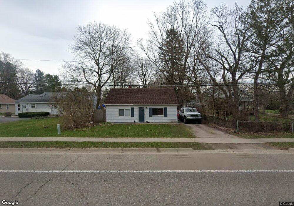
542 S Mckinley Rd Flushing, MI 48433
Estimated Value: $204,000 - $223,000
3
Beds
2
Baths
984
Sq Ft
$215/Sq Ft
Est. Value
About This Home
This home is located at 542 S Mckinley Rd, Flushing, MI 48433 and is currently estimated at $211,674, approximately $215 per square foot. 542 S Mckinley Rd is a home located in Genesee County with nearby schools including Seymour Elementary School, Flushing Middle School, and Flushing High School.
Ownership History
Date
Name
Owned For
Owner Type
Purchase Details
Closed on
Jul 3, 2003
Sold by
Vernon Charles R and Vernon Judith A
Bought by
Burkhardt Jeffrey and Burkhardt Maryann
Current Estimated Value
Home Financials for this Owner
Home Financials are based on the most recent Mortgage that was taken out on this home.
Original Mortgage
$135,850
Outstanding Balance
$57,432
Interest Rate
5.3%
Mortgage Type
FHA
Estimated Equity
$154,242
Purchase Details
Closed on
Jul 20, 1999
Sold by
Vernon Charles R and Vernon Judith A
Bought by
Vernon Charles R and Vernon Judith A
Create a Home Valuation Report for This Property
The Home Valuation Report is an in-depth analysis detailing your home's value as well as a comparison with similar homes in the area
Home Values in the Area
Average Home Value in this Area
Purchase History
| Date | Buyer | Sale Price | Title Company |
|---|---|---|---|
| Burkhardt Jeffrey | $138,000 | -- | |
| Vernon Charles R | -- | -- |
Source: Public Records
Mortgage History
| Date | Status | Borrower | Loan Amount |
|---|---|---|---|
| Open | Burkhardt Jeffrey | $135,850 |
Source: Public Records
Tax History Compared to Growth
Tax History
| Year | Tax Paid | Tax Assessment Tax Assessment Total Assessment is a certain percentage of the fair market value that is determined by local assessors to be the total taxable value of land and additions on the property. | Land | Improvement |
|---|---|---|---|---|
| 2025 | $2,575 | $100,100 | $0 | $0 |
| 2024 | $2,100 | $89,700 | $0 | $0 |
| 2023 | $2,023 | $80,900 | $0 | $0 |
| 2022 | $2,226 | $73,500 | $0 | $0 |
| 2021 | $2,226 | $66,700 | $0 | $0 |
| 2020 | $1,780 | $63,700 | $0 | $0 |
| 2019 | $1,752 | $59,600 | $0 | $0 |
| 2018 | $2,060 | $55,100 | $0 | $0 |
| 2017 | $1,935 | $54,400 | $0 | $0 |
| 2016 | $1,919 | $41,984 | $0 | $0 |
| 2015 | $1,912 | $0 | $0 | $0 |
| 2012 | -- | $41,900 | $41,900 | $0 |
Source: Public Records
Map
Nearby Homes
- 0 E River Rd Unit 50180952
- 538 Autumn Dr
- 0 Winters Eave Dr Unit 50117986
- 6289 W River Rd
- 253 Aberdeen Ct Unit 14
- 309 Arthur St
- 113 N Mckinley Rd
- 410 E Main St
- 401 E Main St
- Lot 1 across from 74 E River Rd
- 6106 E River Rd
- 210 N Hazelton St
- 219 Primrose Ln
- 000 Potter Rd
- 120 Boman St
- 3470 Longmeadow Dr
- 3462 Woodridge Dr
- 3372 Woodridge Dr
- 308 N Seymour Rd
- 537 Sharon Dr
- 530 S Mckinley Rd
- 100 Overbrook Dr
- 108 Overbrook Dr
- 104 Overbrook Dr
- 541 Somerset Dr
- 537 Somerset Dr
- 533 Somerset Dr
- 545 Somerset Dr
- 112 Overbrook Dr
- 529 Somerset Dr
- 525 Somerset Dr
- 512 S Mckinley Rd
- 105 Overbrook Dr
- 101 Overbrook Dr
- 109 Overbrook Dr
- 113 Overbrook Dr
- 538 Somerset Dr
- 542 Somerset Dr
- 530 Somerset Dr
- 539 S Mckinley Rd