Estimated Value: $201,974 - $258,000
3
Beds
2
Baths
1,220
Sq Ft
$191/Sq Ft
Est. Value
About This Home
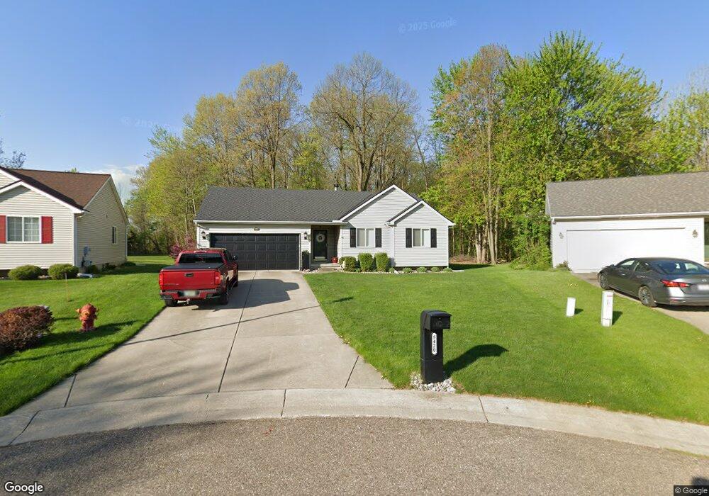
This home is located at 5420 Tall Oaks Dr Unit 20, Flint, MI 48507 and is currently estimated at $232,494, approximately $190 per square foot. 5420 Tall Oaks Dr Unit 20 is a home located in Genesee County with nearby schools including Anderson Elementary School, McGrath Elementary School, and Grand Blanc West Middle School.
Ownership History
Date
Name
Owned For
Owner Type
Purchase Details
Closed on
Mar 19, 2009
Sold by
Mortgage Electronic Registration Systems
Bought by
Federal National Mortgage Association
Current Estimated Value
Purchase Details
Closed on
Mar 6, 2009
Sold by
Rosin Christine and Rosin Donald E
Bought by
Mortgage Electronic Registration Systems
Purchase Details
Closed on
Jul 9, 1999
Sold by
Bald Mountain Development Co
Bought by
Rosin Donald E and Rosin Christine
Home Financials for this Owner
Home Financials are based on the most recent Mortgage that was taken out on this home.
Original Mortgage
$109,650
Interest Rate
7.43%
Mortgage Type
Purchase Money Mortgage
Create a Home Valuation Report for This Property
The Home Valuation Report is an in-depth analysis detailing your home's value as well as a comparison with similar homes in the area
Home Values in the Area
Average Home Value in this Area
Purchase History
| Date | Buyer | Sale Price | Title Company |
|---|---|---|---|
| Federal National Mortgage Association | -- | None Available | |
| Mortgage Electronic Registration Systems | $145,418 | None Available | |
| Rosin Donald E | $25,000 | Greco Title |
Source: Public Records
Mortgage History
| Date | Status | Borrower | Loan Amount |
|---|---|---|---|
| Previous Owner | Rosin Donald E | $109,650 |
Source: Public Records
Tax History Compared to Growth
Tax History
| Year | Tax Paid | Tax Assessment Tax Assessment Total Assessment is a certain percentage of the fair market value that is determined by local assessors to be the total taxable value of land and additions on the property. | Land | Improvement |
|---|---|---|---|---|
| 2025 | $3,656 | $87,300 | $0 | $0 |
| 2024 | $1,572 | $80,900 | $0 | $0 |
| 2023 | $1,500 | $78,900 | $0 | $0 |
| 2022 | $3,022 | $79,900 | $0 | $0 |
| 2021 | $2,985 | $76,600 | $0 | $0 |
| 2020 | $1,383 | $70,300 | $0 | $0 |
| 2019 | $1,362 | $66,600 | $0 | $0 |
| 2018 | $3,028 | $62,500 | $0 | $0 |
| 2017 | $2,978 | $62,900 | $0 | $0 |
| 2016 | $2,961 | $56,800 | $0 | $0 |
| 2015 | $2,859 | $56,300 | $0 | $0 |
| 2012 | -- | $52,100 | $52,100 | $0 |
Source: Public Records
Map
Nearby Homes
- 1226 Harding Dr
- 0 Harding Dr Unit 20251056693
- 1096 Harding Dr
- 5400 Ali Dr
- 1329 Rollins St
- 1075 E Hill Rd
- 00 Mckinley Blvd
- 000 Mckinley Blvd
- 1037 E Hill Rd
- 6137 Pebbleshire Dr
- 0000 Mckinley Blvd
- 0000 Coolidge Dr
- 1329 Arrowwood Ln
- 00 Coolidge Dr
- 000 Coolidge Dr
- 1045 Leisure Dr Unit 7
- 5368 Boland Dr
- 5152 Sandalwood Cir
- 5148 Sandalwood Cir
- 1130 Leisure Dr Unit 21
- 5424 Tall Oaks Dr
- 5414 Tall Oaks Dr Unit 21
- 5410 Tall Oaks Dr Unit 22
- 5406 Tall Oaks Dr Unit 23
- 1218 Harding Dr
- 1215 Ransom Dr
- 5401 Tall Oaks Dr Unit 18
- 5398 Tall Oaks Dr Unit 24
- 1198 Harding Dr
- 1207 Harding Dr
- 1199 Ransom Dr
- 5388 Tall Oaks Dr Unit 26
- 5392 Tall Oaks Dr Unit 25
- 5397 Tall Oaks Dr Unit 17
- 1203 Harding Dr
- 1189 Ransom Dr Unit Bldg-Unit
- 1189 Ransom Dr
- 5384 Tall Oaks Dr Unit 27
- 5393 Tall Oaks Dr Unit 16
- 1188 Harding Dr