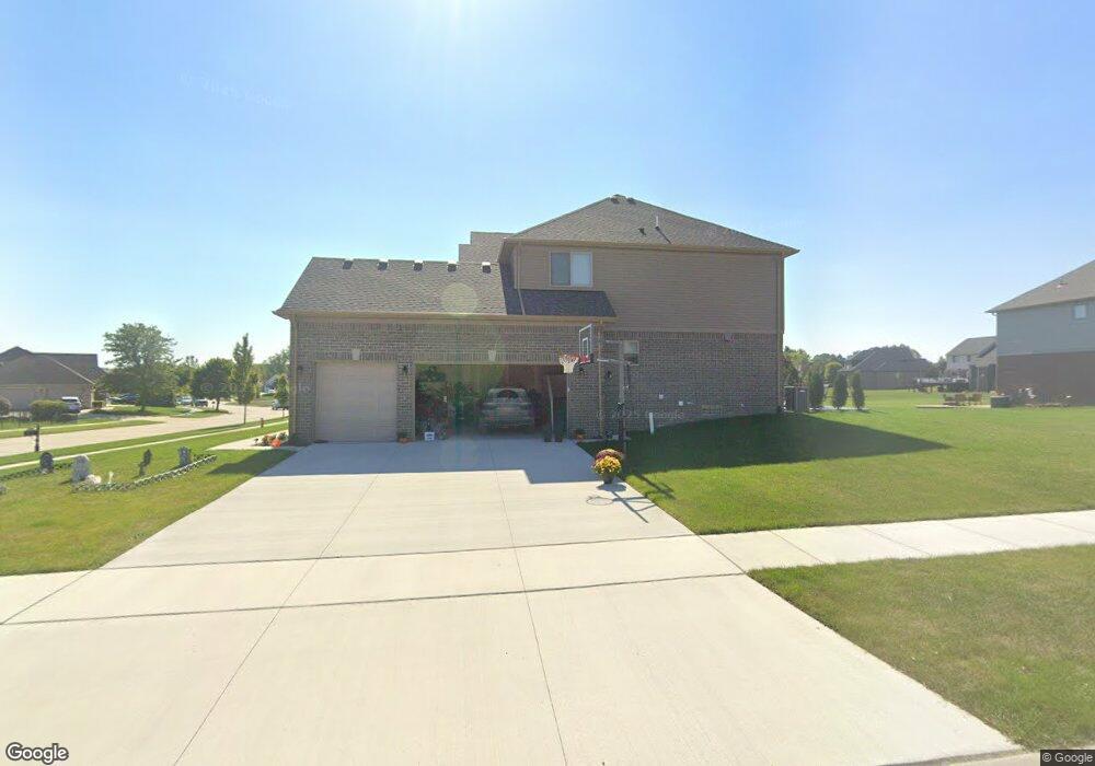
54254 Wexford Dr Unit 59 New Baltimore, MI 48047
Estimated Value: $122,000 - $649,000
4
Beds
4
Baths
2,700
Sq Ft
$184/Sq Ft
Est. Value
About This Home
This home is located at 54254 Wexford Dr Unit 59, New Baltimore, MI 48047 and is currently estimated at $495,466, approximately $183 per square foot. 54254 Wexford Dr Unit 59 is a home located in Macomb County with nearby schools including Lighthouse Elementary School, Anchor Bay Middle School North, and Anchor Bay High School.
Ownership History
Date
Name
Owned For
Owner Type
Purchase Details
Closed on
Feb 17, 2023
Sold by
Cherry Creek Building Llc
Bought by
Westrick Mary and Bogdan Daniel
Current Estimated Value
Home Financials for this Owner
Home Financials are based on the most recent Mortgage that was taken out on this home.
Original Mortgage
$528,150
Outstanding Balance
$511,842
Interest Rate
6.15%
Mortgage Type
Credit Line Revolving
Estimated Equity
-$16,376
Purchase Details
Closed on
Sep 11, 2009
Sold by
Gtr Builders Inc
Bought by
Odyssey Investment Group Llc
Create a Home Valuation Report for This Property
The Home Valuation Report is an in-depth analysis detailing your home's value as well as a comparison with similar homes in the area
Home Values in the Area
Average Home Value in this Area
Purchase History
| Date | Buyer | Sale Price | Title Company |
|---|---|---|---|
| Westrick Mary | $120,000 | Ata National Title | |
| Cherry Creek Building Llc | -- | -- | |
| Affinity Land Holdings Llc | $85,000 | -- | |
| Odyssey Investment Group Llc | $3,265,887 | None Available |
Source: Public Records
Mortgage History
| Date | Status | Borrower | Loan Amount |
|---|---|---|---|
| Open | Westrick Mary | $528,150 |
Source: Public Records
Tax History Compared to Growth
Tax History
| Year | Tax Paid | Tax Assessment Tax Assessment Total Assessment is a certain percentage of the fair market value that is determined by local assessors to be the total taxable value of land and additions on the property. | Land | Improvement |
|---|---|---|---|---|
| 2025 | $10,344 | $265,500 | $0 | $0 |
| 2024 | $8,686 | $251,200 | $0 | $0 |
| 2023 | $365 | $20,000 | $0 | $0 |
| 2022 | $1,155 | $16,600 | $0 | $0 |
| 2021 | $1,156 | $16,400 | $0 | $0 |
| 2020 | $1,045 | $9,900 | $0 | $0 |
| 2019 | $1,171 | $9,900 | $0 | $0 |
| 2018 | $1,178 | $7,400 | $0 | $0 |
| 2017 | $1,193 | $7,400 | $0 | $0 |
| 2016 | $1,107 | $7,400 | $0 | $0 |
| 2015 | -- | $7,400 | $0 | $0 |
| 2014 | -- | $7,400 | $0 | $0 |
Source: Public Records
Map
Nearby Homes
- 35689 Windridge Dr Unit 143
- 35704 Addison Dr
- 35736 Addison Dr Unit VAC
- 35603 Addison Dr Unit 166
- 54261 Cascade Ct Unit 96
- 35873 Glenville Dr Unit 182
- 35962 Cascade Dr Unit 103
- 35925 Windridge Dr Unit 82
- 54161 Carrigan Dr Unit 106
- 35990 Windridge Dr Unit 113
- 37196 25 Mile Rd
- 54173 Avondale Dr
- 53809 Meadow View Ln
- 52511 Washington St
- 52451 Washington St
- 34433 Sandpiper Ct
- 52411 Washington St
- 36556 Orchard Lake Dr
- 54822 Heron Cir
- 55140 Baker Rd
- 54219 Wexford Dr Unit 47
- 35678 Windridge Dr
- 35707 Windridge Dr
- 35721 Windridge Dr
- 35640 Windridge Dr
- 54188 Wexford Dr
- 35739 Windridge Dr
- 35776 Windridge Dr
- 54165 Wexford Dr Unit 49
- 35653 Windridge Dr Unit 144
- 35624 Windridge Dr
- 35765 Windridge Dr
- 35612 Windridge Dr
- 35688 Addison Dr
- 54150 Wexford Dr Unit 45
- 35790 Windridge Dr
- 35637 Windridge Dr
- 35701 Strongford Dr Unit 51
- 35679 Strongford Dr
- 53941 Strongford